Hike.uno
Hike.uno
Login
Login
Username:
Password:
Login
Not registered yet? Registration.
Forgot password?
Brežice

Brežice

Country: Slovenia
Latitude/Longitude: 45,9038696°N 15,5930859°E
Altitude: 166 m
Type: Town
Weather forecast:
Th
Fr
Sa
Su
Mo
Description:
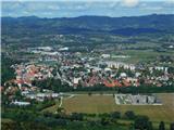
Brežice is a town located at an elevation of 166 meters. The town is located in country Slovenia 1. 6 km north-northwest from the center of Čatež ob Savi and 2 km northeast from the center of Krška vas Near the Town there is also a memorial Spomenik NOB in kmečkim uporom Brežice has 6. 600 inhabitants.
Images:
Brežice
Show map
Points in the vicinity:
Detailed descriptions
Tuščak (Žumberačka gora) (602m)
8,9 km south-southwesterly
Gradina Tuščak (585m)
9,2 km south-southwesterly
Sveti Primož (Kremen) (340m)
9,5 km northwesterly
Webcams
Brežice (HE Brežice)
0,8 km southwesterly
Brežice (river Sava)
0,8 km west-southwesterly
Krška vas
1,3 km southwesterly
Čatež ob Savi
1,4 km south-southeasterly
Prilipe
3,8 km southeasterly
Panoramas
Koča na Bohorju (896m)
21,0 km north-northwesterly
Veliki Javornik (Bohor) (1023m)
22,2 km northwesterly
Dom pri Miklavžu (964m)
25,3 km southwesterly
Trdinov vrh (1178m)
26,7 km southwesterly
GPS tracks
- Brežice Mountain Trail
Žumberačka gora, Medvednica and Međimurje
Brežice - Čatež ob Savi
Žumberačka gora, Medvednica and Međimurje
Čatež ob Savi - Šentviška gora
Žumberačka gora, Medvednica and Međimurje
Brežice - Goli Cirnik
Žumberačka gora, Medvednica and Međimurje
Brežice - Goli Cirnik
Žumberačka gora, Medvednica and Međimurje
Starting points
Stojdraga (Glažuta)
7,9 km southerly
Krško
9,8 km northwesterly
Noršić selo
12,2 km southerly
Smerovišće
13,8 km south-southeasterly
Gorjane (Železno)
15,0 km northerly
         
Copyright © 2026 Hike.uno, Terms of use, Privacy and cookies