|
| VanSims2. 10. 2010 23:20:01 |
Was up there today. Really nice mountain. Well at me the fog didn't dissipate and I was shortchanged on the view. 
Saw some mountain runners both on the forest path and also on the road that leads to the pass.
Otherwise interesting path, especially that gully with fixed ropes.
|
|
|
|
| Jože.3. 10. 2010 07:50:33 |
A few years ago did a circular path on this mountain. In Carnia I drive over the bridge and first turn right a couple of hundred meters more, where I park. The path starts with mark 415 and leads to the abandoned shelter Monte Forcella, at 1098 meters. Here the path turns left, first flat, later steeply up to the ridge, which we follow to planina Aiars.( there I turned around a good month ago because I didn't have the necessary winter gear ) From the planina I turn slightly left to the ridge and along it to the end, where you have to descend a bit to the notch and after a few minutes I'm already at the top. The summit itself and north slope still full of snow. View gorgeous. Descend back to the notch and via path 414, which is initially secured with some cables, to saddle Cristo di Forca, ( some drive to here  ) some time on gravel road, where I turn back to the trail and lower join the road again that leads to the saddle. To Amaro not far then, of course then have to go by road to start, which isn't too pleasant, especially in summer months. But there's a nice pool nearby where you can cool off. Nice circular path, and not demanding. ( unfortunately only two pics left ) ) some time on gravel road, where I turn back to the trail and lower join the road again that leads to the saddle. To Amaro not far then, of course then have to go by road to start, which isn't too pleasant, especially in summer months. But there's a nice pool nearby where you can cool off. Nice circular path, and not demanding. ( unfortunately only two pics left )
| (+2) |  | |
|
|
|
|
| VanSims3. 10. 2010 13:10:08 |
To the saddle, I also drove there 
But as I said I also saw lots of runners. When I was descending the cable one overtook me when he saw that I wouldn't get down for a long time, just climbed over the rocks. Like a goat he climbed on them! 
|
|
|
|
| sabina.727. 02. 2011 20:58:53 |
Today I intended to climb this mountain, but due to wrongly chosen footwear I turned around a bit before the summit, because I'd feel safer with crampons, which I couldn't put on.....technical obstacle! Started almost in the village Amaro, so I did quite some elevation gain. First part through forest is pleasant, then the path winds on overgrown steep slopes, where there are lots of dry branches and storm debris. When you're under the mountain itself then over scree , in the last part full winter gear and caution needed. Track was made to the point where I went, then under soft snow it was icier and I think someone else turned at that point, practically below summit. Maybe easier if you turn to rocks earlier and climb a bit, but I didn't dare. On the path except one chamois, I didn't meet any other living soul. , in the last part full winter gear and caution needed. Track was made to the point where I went, then under soft snow it was icier and I think someone else turned at that point, practically below summit. Maybe easier if you turn to rocks earlier and climb a bit, but I didn't dare. On the path except one chamois, I didn't meet any other living soul.
 1 1 2 2 3 3 4 4 5 5 6 6 7 7 8 8 9 9 10 10 11 11 12 12 13 13 14 14 15 15
| (+2) | | |
|
|
|
|
| kofetarca15. 01. 2012 09:26:02 |
Choice of yesterday's tour was really right despite not expecting "winter" on top. But views all around outweighed that slogging through snow-covered grass As I read from predecessors, this pyramidal mountain also surprised some with winter conditions towards the top 
| (+1) | | |
|
|
|
|
| sabina.76. 07. 2014 21:31:57 |
Today we woke up very early, so at five we were already heading towards today's goal, which was Mount Amariana in the Carnic Alps. In Carnia we left the highway, drove to the village of Amaro and parked. First we walked a bit on asphalt, then turned left and climbed up the lush overgrown path 414 to the Cristo di Forca pass at 1058 m. Most people drive here by car, as there is also an arranged parking lot where quite a few cars were parked today. Here the path continues through the forest and meadows full of various flowers. Paradise for botanists! After an hour of walking the path opens up, we climb grassy slopes to the rocks, where there is also a short easy climbing path that leads us to the top, where there is a statue of Mary with a bell. Today there were quite a few people at the top, both Slovenian and Italian speaking. It's a very scenic mountain!!!!! You have to climb it very early, because otherwise it's too hot. If you start from the village of Amaro, the path is quite long and you do about 1500 meters of elevation gain. In the lower part it's good to spray yourself with tick repellent!!! Worth a visit!
 1 1 2 2 3 3 4 4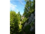 5 5 6 6 7 7 8 8 9 9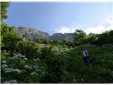 10 10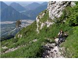 11 11 12 12 13 13 14 14 15 15 16 16 17 17
| (+5) | | |
|
|
|
|
| sla1. 08. 2014 07:46:05 |
Yesterday I also visited this beautiful mountain with an even more beautiful name. I started from the saddle and after five minutes I was soaked from head to toe. But not so much because of the rain, but because of the "jungle undergrowth" that reached over my head many times. On the way back I threw off all my clothes and poured water out of my boots. Still, I was satisfied with the trip on such a rainy day .
| (+4) | | |
|
|
|
|
| ljubitelj gora22. 04. 2018 18:47:27 |
By car on the mountain road (Parcheggio Forca del Cristo 980 m) and then on the marked path to the top of Amariana. There's still some snow below the summit, in the gully, but it was possible without winter gear. Cables are out. Super views from the top, descent via approach route. From Polhograjske Hills there and back 350km (done on gas).
| (+6) | | |
|
|
|
|
| malimiha28. 04. 2018 16:46:26 |
Today my better half, Milan and I went to Amariana. Path without peculiarities. But it really is a very nice viewpoint, definitely worth visiting.
| (+4) | | |
|
|
|
|
| 2061alessio8. 11. 2018 11:51:33 |
for Bagi and others of this forum I would recommend the Carlo Treu path, on Tabacco map 013: parking in village Amaro near the church (there next to spot 322) and then right follow the path (in black on map) uphill next to stream Rio Sgenaulie to spot 922 Stavolo Posselie, here a bit left and straight up through forest and finally through grass and ridge whole path followable but not/or poorly marked (November 2011), some cairns and in the last part from spot 1526 onwards just "on sight" to marked path 415 on ridge, now left to Amariana and then descent whole path 414 to start; or right circular path 415 via Ricovero Monte Forcella to lower white road and then on asphalt to Amaro. Enjoy.
| (+3) | | |
|
|
|
|
| bagi8. 11. 2018 14:20:33 |
Thanks Alessio, I've already added it to the list of ideas for next year
One question ... is this the route that I drew with a yellow line on the map?
 1 1
| (+1) | | |
|
|
|
|
| 2061alessio8. 11. 2018 19:34:59 |
that's it, the last part around spot 1526 I went up pretty directly but it's "on sight" here and there following between grass and rocks poor track, if you look at Amariana from the road of Carnia village, then you'll see/guess that the path goes up like a straight line, almost "direttissima" I'd say. p.s. I'll write something for the new topic CUESTA SPIOLET because it's almost a continuation of your tour to Piciat.
| (+4) | | |
|
|
|
|
| lojze18256. 06. 2019 14:22:40 |
Maybe someone knows what the conditions are like on path 415 to Amariana? Probably no more snow, but still..
|
|
|
|
| bagi24. 11. 2021 17:15:29 |
Una bella giornata in montagna ...
Here and there we learn some Italian words and they perfectly fit this visit to the excellent viewpoint Monte Amariana. We did a circular variant on unknown trails to us and discovered many beautiful things. In no time we burned through the day to the last light, even night had to come to help  . It added up to rich 29 km of trail and 2200m elevation. . It added up to rich 29 km of trail and 2200m elevation.
For starting point we chose a small parking lot next to the hamlet Campiolo Alto. At the first house by the road there's a signpost for path 417. It led us for long along the right side of the Torrente Giagno gorge, which is worth a visit by itself. After a good kilometer the path leaves the gorge and climbs to the extremely interesting village Stavoli. That's also the main reason for the numerous arranged bridges and stairs.
The village Stavoli Moggio Udinese indeed has no other access than the one we took. No road here, only a cargo cableway across the gorge and that only since the 60s. Once 200 families lived here, they even had their own school. Today it has a weekend character, but its patina remains. Excellent reproductions of old village photos with trilingual explanations take care of that. Viewing them takes you decades back and you learn how hard life was then. Recommended .
Even further we encountered remnants of former times for long, but nature slowly takes them back. When they're gone, the path turns into a trail. In the forest it's nicely followable, in the grass a bit less. Markings are sufficient and we had no special doubts. Soon we were at Sella di Dagna saddle and over Cuel di Giai peak to the foot of Amariana. Here starts the steep and long ascent on path 443. It runs on northern slopes, so shady and cool. Higher there were some snow remains, but they didn't bother walking. Just below the summit path 443 joins the very demanding access to Amariana, path Sentiero Dalla Marta ( CLICK ).
The summit was bathed in sun on dark blue background and accordingly endless views. Pleasant temperatures and no wind called for a longer stop, but we couldn't afford much rest. After short snack and little martini sipping we headed on, again into the unknown.
We followed the ridge variant marked 415. Such a beautiful and panoramic ridge we really didn't expect. Steady walking isn't exactly it, because the trail is usually narrow and grassy. Reason probably distant starts and long approach. Anyway, we maximally enjoyed the views and chased the day. When the ridge ends, the path turns to the shady north side and starts steep descent. Due to abundance of autumn leaves and corresponding caution we couldn't descend quickly. So it was all the way to Forcella shelter, where the day was slowly saying goodbye.
Due to excellent trail base further on we weren't worried and dashed to the valley. Original descent plan we slightly changed due to approaching darkness and opted for safer descent on marked path to the bike path. Just before it we had to light our stars, which lit the road for long 5 km all the way to morning starting point. But night has its power and those kilometers passed quickly. Mostly thanks to fast walking due to cold .
Coordinates of start (parking next to village): 46.400709, 13.161229
 1 1 2 2 3 3 4 4") 5 5 6 6 7 7 8 8 9 9 10 10 11 11 12 12 13 13 14 14 15 15 16 16 17 17 18 18 19 19") 20 20") 21 21 22 22 23 23 24 24 25 25 26 26 27 27") 28 28") 29 29 30 30 31 31 32 32 33 33 34 34 35 35 36 36 37 37") 38 38 39 39 40 40 41 41 42 42") 43 43 44 44 45 45 46 46 47 47 48 48 49 49 50 50 51 51 52 52 53 53") 54 54 55 55
| (+10) | | |
|
|
|
|
| polownk199813. 04. 2024 13:44:15 |
Hello,
Has anyone been in this area recently and can tell if there's still any snow on the path?
Thanks and best regards
|
|
|
You must log in to post a comment:
If you do not yet have a username, you must first
register.