Non-stop riddle for beginners 2
|
| tinky24. 05. 2013 14:55:42 |
Osredek is the correct answer to my riddle.
|
|
|
|
| CarpeDiem24726. 05. 2013 09:08:44 |
For help with the answer I would ask for the approximate altitude. 
|
|
|
|
| miri26. 05. 2013 11:59:21 |
|
|
|
|
| tulipan26. 05. 2013 17:47:11 |
Up to 800 m above sea level.
|
|
|
|
| oldtimer 5526. 05. 2013 20:50:14 |
Or maybe Mala Grmada, ridge path to Polhograjska Grmada
|
|
|
|
| tulipan26. 05. 2013 21:20:35 |
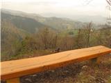
On the bench from the other side there is also height marker and mountain name. Not Mala Grmada, but in Polhograjske Dolomites. In metal box there is summit log.
 1 1
|
|
|
|
| tulipan27. 05. 2013 21:27:19 |
Bench on which Mountain is in the picture?
|
|
|
|
| tulipan28. 05. 2013 07:15:07 |
Let's finish!
Dolinska Gora above Hrastnica valley.
Starting point is Dolinski Mlin.
Continue!
|
|
|
|
| ajda4. 06. 2013 19:03:16 |
Since this stands here I'll give one to make it run 
Where am I walking?
 1 1
|
|
|
|
| tinky4. 06. 2013 19:05:33 |
|
|
|
|
| ajda4. 06. 2013 19:07:41 |
Tinky wow you're fast as lightning correct bravo. Continue
|
|
|
|
| capraibex4. 06. 2013 19:13:08 |
This path is also called the Slovenian mountain path. It connects Stari Ljubelj and Zelenica
|
|
|
|
| tinky4. 06. 2013 19:19:22 |
 1 1
|
|
|
|
| ajda4. 06. 2013 19:25:12 |
Yes, Tinky, that's it, it's not so easy at all, you gotta pay some attention. I went the other day in the afternoon, up the ski slope and back here, really nice 
Didn't know that other name.
|
|
|
|
| tinky4. 06. 2013 19:35:53 |
see current conditions, Karavanke p.4, Hut at Ljubelj along ridge to Zelenica, Tinky. I've walked it three times and will probably do it again. Once we went with friends in reverse, from the hut at Zelenica to Stari Ljubelj.
| (+1) |  | |
|
|
|
|
| sirt16. 06. 2013 19:32:37 |
capraibex - Slovenian mountain path is the name for the Slovenian transversal. But the ridge path, I strongly doubt that it is its integral part.
|
|
|
|
| peterr6. 06. 2013 21:56:13 |
The path along the Ljubeljščica ridge from Ljubelj pass to Zelenica probably arose due to the needs of state border control and was a closed area until 1991. A few years ago (2007), members of the Association of Military Mountaineers renovated and secured the upper rocky section so that it now runs on the Slovenian side (this part previously ran along the rocks on the Carinthian side) and described it in the booklet Vrh Ljubelja smo v Šancah stal; they named it Slovenian path http://www.zvgs.si/index.php?page=static&item=1747&tree_root=425
The path is thus at least as old as the state border between Austria and ,,ranjko,, Yugoslavia (now of course Slovenia). Even older was the pilgrimage path over the Čez pod saddle (right of the rocky towers Na možeh where the current path climbs to the ridge) to the Carinthian side to the old church of St. Lenart in Brode, which is clearly visible on the old military map of Slovenia from 1763.
In all these posts, what bothers me is that the centuries-old Ljubelj pass 1369m is more and more often renamed to Stari Ljubelj (you won't find it on any map). When they opened the Ljubelj tunnel in the early sixties, the border workers took the name Ljubelj with them to the valley. On the house numbers by the tunnel, you can still read Podljubelj. Before the renaming in 1954, this settlement was called Sv. Ana pod Ljubeljem.
Ljubelj pass
http://www.gore-ljudje.net/novosti/49586/
Peter Rožič
| (+7) | | |
|
|
|
You must log in to post a comment:
If you do not yet have a username, you must first
register.