Non-stop riddle for beginners 2
|
| šodrovc14. 05. 2011 17:03:30 |
@Edina
- right-click on your photo and select Properties... 
@atoamac
- goats flew in, and with their bleating drowned out the turtledoves...
|
|
|
|
| atoamac14. 05. 2011 18:11:54 |
It's probably the only chance to wait till they graze, then continue the unsolved riddle with ptarmigans and turtledoves 
|
|
|
|
| zip14. 05. 2011 22:38:08 |
Ptarmigan is gone, Nos remained! Locally also southern slopes of Maharje(1570)
|
|
|
|
| atoamac14. 05. 2011 23:11:23 |
Bravo, zip. So that others understand šodrovc's hint with turtledoves: Mohor (below Tolminski Migovec) is GRUšnica on the map.
|
|
|
|
| atoamac16. 05. 2011 12:56:22 |
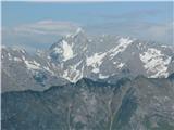
Which peaks are in the picture?
 1 1
|
|
|
|
| Boštjan MK16. 05. 2011 13:58:57 |
This mountain world is not barrenly beautiful at all. Quite the opposite. A masterpiece without equal!
|
|
|
|
| šodrovc16. 05. 2011 19:57:24 |
We get the result with these equations:
photo + syndrome with hint + Šodrovc's nose = central peak (Jalovec) + Šodrovc's nose = central peak (Jalovec)
photo + central peak + Šodrovc's nose = viewpoint (Veliki vrh v Polovniku)
central peak + viewpoint - laziness - keyboard damage = panorama (Ulrich hilfe)
 1 1
|
|
|
|
| IgorZlodej16. 05. 2011 20:10:03 |
What if it was taken from Pirhovec . And this interests me too: Has anyone climbed Jalovec from LK over that beautiful snowfield on the west side of Jalovec? . And this interests me too: Has anyone climbed Jalovec from LK over that beautiful snowfield on the west side of Jalovec?
|
|
|
|
| šodrovc16. 05. 2011 20:17:12 |
possible, sometimes it randomly bugs me
|
|
|
|
| Boštjan MK17. 05. 2011 08:49:46 |
But it sometimes pulls me a bit too much to the right...
|
|
|
|
| atoamac17. 05. 2011 14:34:25 |
Indeed the video was taken on Veliki vrh. And interestingly, Igor, I too wondered about that snowfield when looking that way. Don't know where I read it (probably in Mihelič), that the first ascenders used that snowfield.
Boštjan, nothing wrong if it pulls you right, it'll be fashionable again soon
|
|
|
|
| IgorZlodej17. 05. 2011 15:17:58 |
Well I have already crossed that snowfield, description here: http://www.turni-klub-gora.si/~frances/razmere/RazmereVsebina.php?Obv=04024, also a few years ago I went over there in dry conditions when I went to fetch someone's backpack that fell from Jalovec ridge, only that time I went from Bavšica, through Bale valley to sedlo Čez Brežice to Prode, picked up the backpack contents, climbed to Jalovec summit, descended to Špičko and via Škrbina behind Grad back to Bala and Bavšica. Whoever does this tour truly grasps the greatness and authenticity of Jalovec.
|
|
|
|
| Hribovc8817. 05. 2011 19:39:19 |
Where is that or from where was it photographed?
|
|
|
|
| atoamac17. 05. 2011 20:55:04 |
By the shapes I'd say it's Štajerka
|
|
|
|
| atoamac17. 05. 2011 20:55:48 |
Oops, Štajerska
|
|
|
|
| Hribovc8817. 05. 2011 21:23:58 |
Won't hold. Hint: up there is the start of European hiking trail E6, which is 350 km long. Elevation 650 m.
|
|
|
|
| miri17. 05. 2011 21:43:12 |
|
|
|
You must log in to post a comment:
If you do not yet have a username, you must first
register.