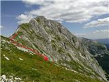
Traverse Mišelj vrh - Mišeljski konec
|
| šodrovec13. 08. 2013 21:54:10 |
Maemi, if I understand correctly you crossed Mišeljska dolina after traversing the valley under Škednjovec and continued the original variant under the wall around the foot of Mišeljski vrh to the scree under Koštrunovec, climbed to the meadow and continued on the often described passages to the top ... Quite interesting! By the way, approx when were you at the top with such a route? Where exactly did you leave the ridge on return - you mention "beautiful descent on scree"?
|
|
|
|
| Maemi13. 08. 2013 23:20:07 |
From Rudno polje to Mišelj vrh I took approx. 6h (from Rudno polje to Mišelj planina 2h 45min), but from Mišelj planina to the steep grassy slope on Koštrunovec unnecessarily at least one hour for stopping, calculating, map checking and analyzing the description. The path is really beautiful, covered with dense gentians at the start from Mišelj preval under Škednjovec slope and easy to cross. I reached Mišelj vrh top only at 12h almost simultaneously with two hikers who came from Mišeljska dolina along the ridge and told me about this descent, otherwise I would have descended via screes from the ridge under Mišelj konec to Velska dolina (Dolič).
From Mišelj vrh short descent along ridge to "saddle", before the ridge rises slightly again, descend from ridge to south slope. At start very steep grassy and rocky, soon visible scree where faint paths of previous hikers are noticeable. The scree at beginning steep like conveyor belt, very pleasant for experienced Soon cairns visible too, even before descending from scree to rocky slope - debris cone (hope I named it right), where narrow white path with many cairns down Mišeljska dolina is already noticeable. Soon cairns visible too, even before descending from scree to rocky slope - debris cone (hope I named it right), where narrow white path with many cairns down Mišeljska dolina is already noticeable.
 1 1
| (+4) |  | |
|
|
|
|
| šodrovec14. 08. 2013 10:17:05 |
Thanks, Maemi!
Actually, you spent little time on the "unnecessary" ascent to Mišeljski preval and traverse to below Koštrunovec, and it was definitely worth every step. The orientation overview towards Mišelj vrh and right to Koštrunovec, offered by the gentle slopes under Škednjovec is first-class and worth recommending to anyone willing to deviate a bit from the "shortest" path, especially if coming from Jezerca or Laza (this way avoiding descent to pasture Pod Mišelj vrhom).
Regarding descent, I was curious if you discovered some "new" scree in the central part of the ridge. Now I know you chose the "classic" descent/ascent route (your photo with markup will be useful to someone), but to me, the pampered one, that scree seems rough. But the little ridge from the top to the saddle (your photo) also seems just exposed enough in places to mention. Anyway, tastes and mountain feelings can be (daily) different, so your notes on ascent over Koštrunovec are only useful and not unnecessary at all.
At the end, let me do what I should have at the start: congrats on the nice tour!
| (+1) | | |
|
|
|
|
| Maemi15. 08. 2013 10:16:56 |
Thanks Šodrovec
Safe in the mountains everyone!
| (+1) | | |
|
|
|
|
| milepetro4. 09. 2013 20:49:57 |
I'm curious how much time is needed from Pl. Blato via Pl. Krstenica, Jezerski preval Koštrunovca to Mišelj vrh and then along the ridge towards Hribarice, to Zasavska koča na Prehodavcih, across Triglav Lakes valley to koča na Triglavskih jezerih and then back via Štapce past pl. pri Jezeru to pl. Blato. I plan to do this tour this week. Thanks for reply.
|
|
|
|
| sla28. 10. 2013 09:02:51 |
On Saturday I managed a circuit around Debeleg vrh. Route: Pl. Blato, Pl. Krstenica, Krsteniški Stog, Jezerski Stog, towards Pl. pod Mišelj vrhom, Mišelj vrh, Mišelj Konec, where I found direct descent to Hribarice (I'd rate it supported II), Vrata pod V. Zelnarico, both Zelnarici, Kopica, Pl. Dedno polje, Pl. Jezero, Pl. Blato. All together took me 9.5 hours, even 2 liters of drink was too little in hot sunny weather. Tour fantastic, still feel the fatigue today 
| (+2) | | |
|
|
|
|
| peter4629. 10. 2013 09:03:28 |
@sla: No no that from M.Konec to Hribarice really isn't a II..
| (+1) | | |
|
|
|
|
| šodrovec29. 10. 2013 12:01:25 |
Ambitious. Sla, congrats!
Rating of direct descent from Mišelj Konec (to Hribarice) down the gully to the left and in the lower part over a jump to scree under the wall is also in my opinion within crumbly II.
| (+1) | | |
|
|
|
|
| felix29. 10. 2013 13:33:48 |
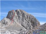
Since I'm also planning this traverse, probably next year, I'm interested in which is the correct passage from Mišeljski konec. I'm attaching a photo, if I understand correctly, is it the right gully in the photo?
Thanks and best
 1 1
|
|
|
|
| sla29. 10. 2013 14:36:33 |
In the photo it really looks like that. I went left along the left gully (don't hold me to my word!). From above it looks completely different. Even when I looked back from Hribarice, I wasn't quite sure where I descended.
But there are two normal descents from MK. If you return along the easy slope back east (that's the visible path where you came) to the saddle, there are beaten paths there to Mišeljska dolina and to Velška dolina. Neither one nor the other descent is a significant detour to Hribarice.
Somehow I managed to draw where I climbed down.
 1 1
|
|
|
|
| robi1429. 10. 2013 16:09:02 |
@sla: how much elevation difference is there? Between scree and summit?
|
|
|
|
| knap422729. 10. 2013 20:12:07 |
Every eye has its own painter, I went down in the area of the left gully, from the top it's about 100 meters, scrambling I - II a bit less. Best
| (+1) | | |
|
|
|
|
| šodrovec29. 10. 2013 22:04:43 |
It's been 14 years since I last went down there, so I really can't reliably claim how big they were then in the lower 30 height meters to my eyes. But I remember well that some before me and some after me already had similarly sized ones (II.). Good luck there and elsewhere, regardless of the painters! 
|
|
|
|
| sla30. 10. 2013 07:34:58 |
Climbing is definitely much less than 100 m. I didn't dare descend the left gully because it's full of scree that can slide under your feet, and you slide with it...
|
|
|
|
| JusAvgustin30. 10. 2013 11:43:21 |
If there's one thing we know on this forum, it's exaggeration... In all aspects!
|
|
|
|
| peter4630. 10. 2013 12:02:33 |
Yeah Slavica (sla) always likes to exaggerate - to her own advantage, you understand
| (+1) | | |
|
|
|
|
| Bojan_A30. 10. 2013 14:29:31 |
It's not about exaggeration. It's a "route" graded II, which is ridiculously easy for many, I understand. Whoever doesn't know what that means should rather take a rope.
| (+2) | | |
|
|
|
|
| jax30. 10. 2013 15:43:29 |
And what will the rope help him? Probably there's nothing on the route, so having just a rope is exactly the same as having nothing. In the end, every time it's said that you need a rope, we also have to say you need a hammer and a few pegs, and some bolts too. And of course a partner. Which is of course pretty meaningless in such places. In reality, in that world (easy I and II) belaying is more or less meaningless. Such routes are free-soloed, and if someone doesn't feel up to it (as I don't for many things), then better not tackle them at all.
| (+2) | | |
|
|
|
|
| zippo31. 10. 2013 07:59:55 |
Sla and Bojan are right about the difficulties in the gully. The rope can really help because there are a couple of pegs hammered in for descent, I could have used it but didn't feel like carrying it, because I listened to puffed-up comments from someone I went to ask for advice
| (+17) | | |
|
|
|
You must log in to post a comment:
If you do not yet have a username, you must first
register.