Ljubelj - Dom na Zelenici
Starting point: Ljubelj (1058 m)
| Latitude/Longitude: | 46,43240°N 14,26020°E |
| |
Walking time: 1 h 20 min
Difficulty: easy marked way
Elevation gain: 478 m
Elevation difference along the route: 480 m
Map: Karavanke - osrednji del 1:50.000
Recommended equipment (summer):
Recommended equipment (winter):
Views: 173.263
 | 6 people like this post |
Access to starting point:
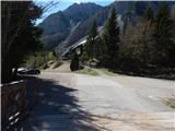
We drive to the border crossing Ljubelj, where before the tunnel we turn left towards Zelenica. We then drive across a small bridge and park on a large parking lot.
Route description:
At the beginning of the parking lot, the signposts for Stol, Vrtača and Dom na Zelenici point us onto a wide cart track which starts ascending by the torrent. When a little higher the cart track turns left, we continue straight on the mountain path which continues through the forest and soon returns to the cart track. The cart track a little higher turns right and brings us out of the forest onto the ski track of the former ski slope Zelenica. Next follows a short steeper ascent on the ski slope, then the path flattens and leads us by the foot of the scree below Begunjščica.
From the marked path soon a path which runs on a transport road branches off to the right, and we continue on the "road" to the nearby Koča Vrtača hut.
At the hut the road turns right, and we continue straight in the direction of the mountain path to Zelenica. For a short time we continue below the former one-seater chairlift Zelenica II, then the path starts to ascend more steeply on a slope which is partly overgrown by dwarf pines. After a few hairpin turns we return to the transport road, on which we continue with a view towards the Šentanski plaz.
The path ahead leads us on the slopes of Spodnji plot (peak on which they made a sport climbing path a few years ago), then from the road we turn right onto a footpath which cuts a longer bend. When we return to the road we are already at the upper station of the former one-seater chairlift Zelenica II, and only a few steps of descent separate us from the Dom na Zelenici hut.
Description and pictures refer to the condition in the year 2017 (April).

The trip can be extended to the following destinations: Dom pri izviru Završnice ( 20 min),
Roblekov dom na Begunjščici (2 h),
Klagenfurter Hutte/Celovška koča (2 h 50 min),
Spodnji Plot,
Vrh Ljubeljščice (Triangel) ( 30 min),
Na Možeh ( 55 min),
Srednji vrh (above Završnica),
Žleb (Suho ruševje) (1 h 20 min),
Srednja peč,
Bielschitza/Svačica,
Pautz/Zelenjak (1 h 35 min),
Selenitza/Palec (1 h 40 min),
Begunjščica,
Prešernova koča na Stolu,
Vertatscha/Vrtača,
Hochstuhl/Stol
Photos:
 1
1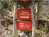 2
2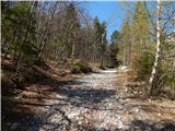 3
3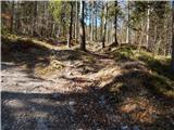 4
4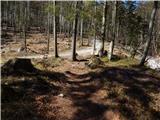 5
5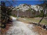 6
6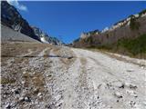 7
7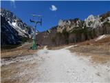 8
8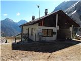 9
9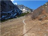 10
10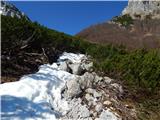 11
11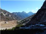 12
12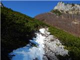 13
13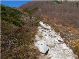 14
14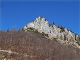 15
15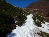 16
16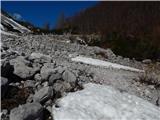 17
17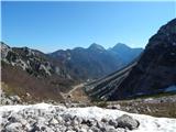 18
18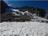 19
19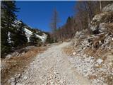 20
20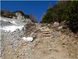 21
21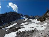 22
22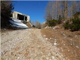 23
23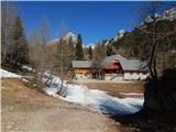 24
24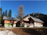 25
25
Discussion about the trip Ljubelj - Dom na Zelenici
Show older messages
|
| Gost8. 07. 2006 |
Shame, what is PD Tržič doing with Zelenica. Where is the money from the burned hut. Destroyed nature with the road. Arrogant caretaker, who only changes locations. Catastrophe.
|
|
|
|
| Peter Rožič18. 09. 2006 |
It's easiest to criticize!
If it weren't for a few enthusiasts (Zeleničarjev), who invested a lot of effort and volunteer hours of work, there wouldn't even be this modest shelter! All the money that was obtained for the hut renovation was also spent on it (there is documentation for that). The Ljubelj-Zelenica road was neither built nor financed by PD Tržič.
|
|
|
|
| Gost20. 09. 2006 |
Several times a year I am on Zelenica (regardless of the season) and it's always nice up there and pleasant in the hut too. Whenever I've been so far, a very cheerful, pleasant and friendly lady has been serving, who also chats with hikers if she doesn't have too many visitors. But we hikers need to realize: the hut on Zelenica is currently built only to the stage for which there was money, and let's be glad that we can at least get tea and some other drink. It's no big deal if one day the hut isn't as big as it was before the fire. Anyway, we go to the mountains mainly to be in nature and not in the hut. Not all huts or keepers are sympathetic to me either. I avoid those and go past them. I do agree that the road to Zelenica is a big scar on nature. Probably because of skiing and not hikers. Nevertheless, Zelenica will always be just as dear to me and a nice starting point for further afield.
And safe and happy trails to all on the mountain paths. MiR
|
|
|
|
| kolesar8. 10. 2006 |
Today I was at Zelenica and I tell you, the lady behind the counter was very friendly. 
|
|
|
|
| Gost12. 02. 2007 |
On Zelenica I'll have a camp during my holidays, hope it's nice 
|
|
|
|
| Gost15. 09. 2007 |
Is there a path from the old Ljubelj Pass to Zelenica?
Regards Pipi
|
|
|
|
| Gost15. 09. 2007 |
No, it doesn't exist! Possible only via pathless terrain, where some climbing and orientation skills are required.
|
|
|
|
| Gost15. 09. 2007 |
Thanks for the reply. I heard there is an unmarked path, but it was probably disinformation, or my informant confused the path with the trail that border guards used sometimes (I walked the lower part today).
Regards Pipi
|
|
|
|
| Gost16. 09. 2007 |
Last autumn I walked the path from the old Ljubelj to Zelenica. In some places very crumbly and slippery, caution needed. Also a shorter section to climb on pitons and along a chain.
|
|
|
|
| Gost16. 09. 2007 |
Thanks for the answer. I would need a slightly more precise description, because I don't want to get lost. Is the path perhaps marked? Is it perhaps part of some other path?
Best, Pipi
|
|
|
|
| Gost16. 09. 2007 |
Best to ask at the hut at the old Ljubelj. There is also a sign for Povna peč and Ljubeljščica, which directs to the path that starts behind the hut and is initially very friendly. It climbs to Povna peč and then continues along an increasingly broken, exposed trail. Markings go up to the sign that says something like: proceed at your own risk, dangerous path... it is indeed dangerous due to the risk of slipping, as the terrain is very crumbly. I also remember a rocky step that needs to be climbed down, which caused me quite a few problems. Because of this passage, which is equipped with pegs and a chain, I would next time prefer to hike this path in the opposite direction. Before reaching the top of the ridge above Zelenica, the trail descends a bit down among the larches, then a strenuous ascent over scree follows, without a clearly marked path to the top of the ridge, which descends on the other side to Zelenica. Good luck and be careful!
LpLj
|
|
|
|
| mojcej'7225. 04. 2010 |
Today, on 25.4.2010, we decided to go towards Dom na Zelenici to see how the renovation of the hut is progressing. When it's all finished, it will be great. The path to Vrtača is dry, further on only along "that wide path - right", some of us went straight up through the snow. Of course, for some it's pure pleasure, for others it can be a nightmare. On the way we met at least 10 ski tourers and all had a smile on their face. The weather was sunny partly cloudy - as forecasted and just right. Great day.
|
|
|
|
| peterr25. 04. 2010 |
Not only ski tourers, but also some smiling climber could be found. In the south wall of Sposnjega Plota (wall above the upper section of the chairlift) it was quite pleasant today. When we returned along the old border guard path, which runs about 100m above the "service path" along the slope of Ljubeljščica, we saw what power avalanches have, as a about 50cm thick beech was snapped like a matchstick.
|
|
|
|
| klavdy69. 05. 2010 |
From the hut at Vrtača, there is still quite a bit of snow on the marked path to the hut at Zelenica, which can be avoided on the wide trail a little before the hut. Otherwise suitable for a short afternoon Sunday trip
|
|
|
|
| skalar5018. 08. 2010 |
I agree with the last sentence - very suitable if you don't have much time, but still want to gaze at the rocks or a nice variant for families. For mere nature enjoyers in the style of "without effort" or those who walk with difficulty (or want to gain time for the tour towards Stol, to the Austrian side, "Begunjščica and jump to Vrtača circle", etc.) there is the option of a weekend morning variant using the cable car. When the Dom (finally) is completed ("something spoon-fed" and drinks are already available in summer now) it will be even better...
|
|
|
|
| skalar5018. 08. 2010 |
...in my humble opinion, the area Zelenica - Vrtača in spring is one of the most beautiful in our country, if you are a lover of alpine flowers...
|
|
|
|
| Pohodnica5611. 12. 2010 |
Maybe someone knows what the conditions are like to Zelenica. Tomorrow will be another nice day and I would head up there.
|
|
|
|
| Pohodnica5611. 12. 2010 |
Geolog79,: I believe it and of course thanks for the two replies. I wasn't sure that anyone would respond if I just write here, so I also used the forum.
|
|
|
|
| katjuša23. 07. 2011 |
Today I was here for the first time and definitely will come again.
The hut is beautiful, clean, simply all pluses.
Same plus for the staff.
lp
|
|
|
|
| gcsaba216. 07. 2011 |
Also praise for the staff, they were very friendly!
|
|
|
|
| Lunca16. 07. 2011 |
only the food isn't the best... I myself ran into burnt and watery beans...
|
|
|
|
| Loni22. 10. 2011 |
Nice, in the dark and snow this trail is completely different, which in normal conditions (as far as I'm concerned) is long-lasting. Several times I sank in deeply, but downhill it was really cool.
In the hut it's pitch black darkness.
|
|
|
|
| stanko14. 11. 2011 |
Dear visitors of Zelenica,
we inform you that the mountain hut on Zelenica will be staffed from this weekend onwards every weekend (from Friday afternoon to Sunday evening) and all holidays (afternoon before the holiday to the last day of the holidays in the evening). During the operation of the Zelenica ski slope, the hut will also be open on other days.
For all information, the new caretaker is available:
Srečo Mažgon, GSM: 070 896 930.
Welcome to Zelenica.
|
|
|
|
| skalar505. 11. 2011 |
finally it's been sorted out... but they should also restore the access road to its old state (before laying the cables) (earth, mud) it wouldn't be bad either....
|
|
|
|
| snork5. 11. 2011 |
If the mud bothers you, go on the path... there will be snow soon anyway
|
|
|
|
| stanko15. 11. 2011 |
Mud is only on the road.... there's none on the hiking path.
|
|
|
|
| skalar505. 11. 2011 |
sometimes the point is between the lines...
|
|
|
|
| Kokta18. 12. 2011 |
Nice weather and nice snowy path, just too bad I didn't load a snowboard on my back, so I could only watch the enjoyers on the pipe and tell myself next time me too  . Anyway cozy walk to the hut. Recommend extending the path to the top of the ski slope, where you will be rewarded with a beautiful view of the neighboring snowy Austria. . Anyway cozy walk to the hut. Recommend extending the path to the top of the ski slope, where you will be rewarded with a beautiful view of the neighboring snowy Austria.
|
|
|
|
| stanko125. 12. 2011 |
Dom na Zelenici will be open from Friday afternoon 23.12.2011 until Monday evening 2.1.2012.
|
|
|
|
| potočan25. 12. 2011 |
In the coming days I plan to hike to Zelenica, but from the opposite side, so I'm curious if anyone knows the condition of the road through Završnica valley to Tičkova hut.
|
|
|
|
| trmmma25. 12. 2011 |
the road is dry, some snow possible only above 1000 m. Otherwise the road is well maintained, only near the top before Tičkova hut there are usually large ditches. enjoy
|
|
|
|
| Pohodnica5626. 12. 2011 |
True I've already been to Zelenica from this side, I know the path, last time I parked a little below Tičkova koča, I'm interested if I should park right at the arranged parking lot below (junction for Valvasorjev dom), if the road ahead were impassable due to snow, how much walking is there then to Tičkova koča. Thanks to everyone for any tip.
|
|
|
|
| mgrego2231. 03. 2012 |
My husband and I have been several times on the circular route from Zelenica to Roblek and to Preval, then through Bornov tunel to Ljubelj. For us it's one of the nicest circular trails. Especially we are attracted by female hikers whom we noticed quite by chance when we quenched our thirst. In short, in all three huts excellent atmosphere, friendly staff and good food. The hut at Zelenica is especially beautiful, really praiseworthy, very nicely set up. It has a special modern style. At Preval they have the best štruklji anyway, worth sinning for.
|
|
|
|
| mgrego2231. 03. 2012 |
Can someone report if the trail is dangerous now, is there still snow, or are crampons needed from Zelenica to Begunjščica and to Roblek and back through Bornov tunel.
|
|
|
|
| stanko121. 04. 2013 |
Trekking poles were found today in the hut on Zelenica. Owner can pick them up on weekends when the hut is open.
|
|
|
|
| AljošaP1. 06. 2013 |
Does the cable car to Zelenica operate on weekends?
|
|
|
|
| jedriličar1. 06. 2013 |
The cable car hasn't been operating for a couple of years...
|
|
|
|
| urbancek2. 06. 2013 |
The cable car did not operate only in this winter season, last year it didn't operate due to practically no snow.
So glider boy, don't write what isn't true
|
|
|
|
| slamca2. 06. 2013 |
And it won't anymore - it has retired. No money for a new one.
|
|
|
|
| viharnik2. 06. 2013 |
At least the cable car operators won't complain anymore when touring skiers climb up, he,he
|
|
|
|
| jedriličar2. 06. 2013 |
@urbancek: last year (winter 2011) the hut keeper told me that the cable car no longer has a valid permit ...
|
|
|
|
| mgrego2231. 05. 2014 |
What's the path to Zelenica like? Now there's probably no more snow? The path from Zelenica to Begunjščica, or to Roblekov dom, is probably still not snow-free and thus dangerous. Has anyone gone through?
|
|
|
|
| alenka4s19. 10. 2014 |
The hut is great with friendly staff and good food.
Easier Sunday outing with kids.
|
|
|
|
| mgrego2229. 11. 2014 |
Is there any snow on Zelenica yet? Can you still get through Zelenica to Roblekov dom or is the path already dangerous? Hopefully someone knows if sledding from the old Ljubelj will be allowed this year with the right amount of snow, of course.
|
|
|
|
| fonko3. 06. 2015 |
Nice tour for a beautiful day. The larger part of the path has the sun shining on your back, so don't go up in extreme heat.
Good luck and safe steps!
|
|
|
|
| k.nina1. 08. 2015 |
Nice path and super hut!
We extended the trip to the Hut at the source of Završnica - wonderful view of Bled. Recommended!
|
|
|
|
| Hribolazec8129. 06. 2016 |
Zelenica is the most beautiful, I come from Styria, I've been there several times and on Saturday I'm going again to these natural beauties
|
|
|
|
| Pelca26. 08. 2016 |
The hut is exceptionally beautiful, renovated, and the surroundings are gorgeous. One of the few huts offering pancakes
|
|
|
|
| maks571. 12. 2016 |
This year my wife and I will celebrate New Year's Eve at the hut on Zelenica. I'm sure we'll enjoy it.
|
|
|
|
| keti124. 01. 2017 |
I'm interested if now in winter time on the path from Ljubelj to Zelenica and also at the hut there is any sun, or is it mostly shady? I plan to go in the morning. If someone has walked these days, please tell me if the path is icy. Thank you.
|
|
|
|
| tristic24. 01. 2017 |
@keti1 This weekend we were up there for three days with kids from the youth section of PD Mengeš. The path is normally passable, snowy and not icy.
As the caretaker says, the sun hits the hut on February 8th . Now it's completely in the shade. But the path there is sunny and the viewpoint at the weather station (above the hut) too. Lots of sun! Good luck
Info in the picture here:
Zimovanje na Zelenici 2017
|
|
|
|
| keti124. 01. 2017 |
@tristic Many thanks for the detailed reply.
|
|
|
|
| milan5828. 09. 2017 |
It's sad that the ski slope has been permanently closed. This ski slope was very popular, I often skied there right before the closure. But it's true that the chairlifts were over 50 years old and very slow. With us, money is only collected as long as possible, but when repairs are needed, it's easiest to close.
|
|
|
|
| capraibex28. 09. 2017 |
The ski slope is no more, green winters have done their job, obsolescence of facilities. Studies by Austrian experts years ago rated the ski slope as risky or dangerous mainly due to the high avalanche risk.
|
|
|
|
| jax29. 09. 2017 |
Protection against avalanches is possible. Of course, that also involves investments.
|
|
|
|
| Marko Torelli18. 10. 2017 |
Just today I was on Zelenica, nostalgically remembering the times ten years ago when, during some rich winters, we skied "on the rope" to exhaustion. Right at the top we crossed right and on first-class powder to the middle station. During the long ride back we admired Begunjščica and rested, because that powder tires you a bit more and the long panoramic ride with "that old one" fit perfectly. And again scouting where it's still virgin for the next track. In short, unforgettable. Back then irreplaceable by any Superski Dolomiti, France or whatever. Excellent.
|
|
|
|
| nadave30. 01. 2018 |
Hello! I'm interested in how the path to the hut on Zelenica is now? Is winter gear needed or not? Thanks for the answer!
|
|
|
|
| slamca30. 01. 2018 |
"Tevice" on your feet and go. It's winter after all.
|
|
|
|
| jax30. 01. 2018 |
The ascent along the ski slope is steep, icy and often frozen. For a safe ascent, and especially descent, crampons are really recommended.
Along the road, of course, there are no such problems, but it can be dangerous there in poor avalanche conditions.
|
|
|
|
| Jošt13. 09. 2023 08:03:15 |
is the hut open today?
|
|
|
To post a comment you must log in:
If you do not yet have a username, you must first
register.