Mrzli studenec - Veliki vrh (Košuta)
Starting point: Mrzli studenec (1300 m)
| Latitude/Longitude: | 46,41460°N 14,33140°E |
| |
Walking time: 2 h 15 min
Difficulty: easy marked way
Elevation gain: 788 m
Elevation difference along the route: 788 m
Map: Karavanke - osrednji del 1:50.000
Recommended equipment (summer):
Recommended equipment (winter): ice axe, crampons
Views: 154.597
 | 5 people like this post |
Access to starting point:
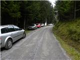
From the Ljubljana - Jesenice highway, take the Ljubelj exit. Then drive to the center of Tržič and follow the road through Dolžanova gorge to the village Jelendol, where signs for the mountain pastures Kofce, Šija and Pungrat direct us left. The road then loses the asphalt covering and starts ascending steeply. Follow this road at the crossroads in the direction of the mountain pasture Kofce. When we notice signs for Kofce and the chapel by the road, park on the parking lot by the road (to here from Jelendol approximately 4.7 km).
If we miss this starting point, we can reach the mountain hut Dom na Kofcah also via two nearby paths, which are well marked (possible also via a worse road).
Route description:
From the parking lot, we head onto the footpath in the direction of the mountain hut Dom na Kofcah and the chapel. The relatively steep path brings us after approximately 20 minutes of walking out of the forest onto a clearing on the edge of which we notice the chapel.
Further, we continue on a cart track that ascends over a strip of forest and higher brings us onto the grassy slopes of the mountain pasture Kofce. From here to the mountain hut on Kofcah we have only a few minutes of pleasant walking.
From the mountain hut, we continue in the direction of Veliki vrh and Kladivo on an initially somewhat less visible path that starts ascending over a panoramic meadow. After 15 minutes of walking from the Dom na Kofcah hut we arrive at a nice viewpoint by the cross.
The path then slightly descends and in a few minutes brings us to the steeper slopes of Košuta. The path then ascends over a strip of dwarf pines, bringing us to a junction. We continue straight ahead (right to Kladivo and Kofce gora) on the path that ascends transversely over increasingly steep slopes. The path, which continues over an unvegetated slope, soon brings us to a short steep section where a steel cable assists us (undemanding). After passing this section, the path turns slightly to the left and continues relatively steeply ascending over the grassy slope. The increasingly panoramic path then brings us into a small valley through which we ascend almost to the border ridge, where the ridge path joins from the right. The path then from the valley again moves onto the southern slopes, where it bypasses the peak »Toplar (2000m)« on the southern side and thereafter brings us below the summit slope of Veliki vrh. The path, which for a while ran along the ridge, here withdraws from it and continues in a transverse ascent over the sunny slopes. Higher up, the path turns sharply right and then in a few minutes brings us to the panoramic summit.
Starting point - Kofce 30 minutes, Kofce - Veliki vrh 1:45.

Photos:
 1
1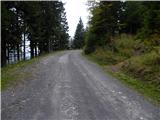 2
2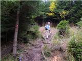 3
3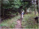 4
4 5
5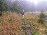 6
6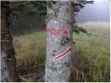 7
7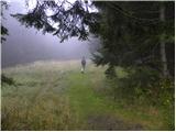 8
8 9
9 10
10 11
11 12
12 13
13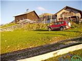 14
14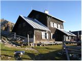 15
15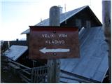 16
16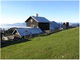 17
17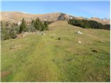 18
18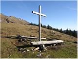 19
19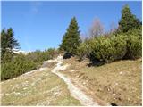 20
20 21
21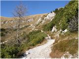 22
22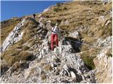 23
23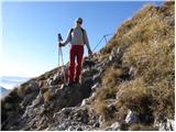 24
24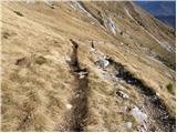 25
25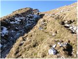 26
26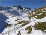 27
27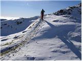 28
28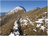 29
29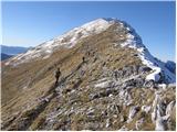 30
30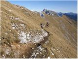 31
31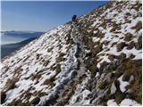 32
32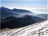 33
33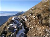 34
34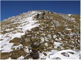 35
35 36
36
Discussion about the trip Mrzli studenec - Veliki vrh (Košuta)
Show older messages
|
| Gost7. 08. 2007 |
Brane V. - first tour this year in Karavanke - quite suitable for a first tour. Road in poor condition, recommend only for off-road vehicles. Kofce is really a nice place for a rest. Lots of visitors. Then follows an easy, not too long hike to Veliki vrh. Today it was exceptionally nice, not too hot, nice view.
|
|
|
|
| heinz18. 06. 2009 |
From Tržič to Mrzli studenec or the starting point (along the road we don't notice the actual chapel, but only the sign for it; -to avoid confusion), it's quite a long way (almost half an hour drive). No harm checking if we have enough fuel in the tank. Gas stations are quite far from here..
|
|
|
|
| Kriška19. 06. 2009 |
If you've driven this road these days, I'm curious about its current condition?
|
|
|
|
| heinz19. 06. 2009 |
That was yesterday. The condition of the path or road is O.K. No tire tracks or anything similar. You drive nicely - on a leveled surface.
Best, Heinz !!
|
|
|
|
| Mate0719. 05. 2010 |
What are the conditions like on Veliki vrh?
|
|
|
|
| DD24. 05. 2010 |
Yesterday we headed to Veliki vrh via the mentioned path, the road to koča is normally drivable, conditions at the top are good, snow on the south side is practically none or it doesn't hinder walking.
lp
|
|
|
|
| robter23. 08. 2010 |
Yesterday we started a family all-day hike. Rest at Kofce for 5 minutes, continuation of the path to Veliki vrh, also conquering Toplar (2000 m) in between. After a snack on the summit we went back and crossed the ridge towards Veliki Kladivo, over Kofce gore. Short stop at Mali Kladivo and then ascent to Veliko Kladivo. Followed by descent to planina Šija and onwards towards Kofce and to the car.
Total net walking approx. 5 hours, gross 8 hours. The weather was really ideal, so we didn't rush and enjoyed the views on Kladivo for one hour.
|
|
|
|
| Zvonček31. 08. 2011 |
Hello,
soon we plan to go to Kofce from Mrzli studenec. What's the condition of the road this year? If I read the above comments, it was in very bad condition in 2007, good in 2009, maybe it's the same this year?  LP LP
|
|
|
|
| DiNoce31. 08. 2011 |
I was up there in July and the road is nicely passable. A bit slower but you can get up.
|
|
|
|
| rebecca23. 01. 2012 |
Hi,
interested if anyone has been up this path recently and what the conditions are like? Thanks for the reply
|
|
|
|
| Kofce24. 01. 2012 |
Hi! The road from Jelendol to Kofce is nicely icy and snowy  , so access with a normal car is not possible... even 4x4 might need chains!! Then the path past the chapel to us is passable with small crampons, further on hikers told us that big crampons are mandatory as the path is trodden but dangerous... a bit more snow has fallen again and in some places it's drifted over the waist Safe and happy trails! , so access with a normal car is not possible... even 4x4 might need chains!! Then the path past the chapel to us is passable with small crampons, further on hikers told us that big crampons are mandatory as the path is trodden but dangerous... a bit more snow has fallen again and in some places it's drifted over the waist Safe and happy trails! 
|
|
|
|
| rebecca20. 03. 2012 |
Hi,
asking again how the access road to Mrzli studenec is with a personal car, namely on Friday we'd like to head to Veliki vrh via this path?
Thanks for the reply
|
|
|
|
| Kofce20. 03. 2012 |
...the road to the flat is now completely dry and therefore no problem Good luck!
|
|
|
|
| balon11. 08. 2013 |
what is the condition of the road to the starting point?
Thanks and best regards
|
|
|
|
| tinky11. 08. 2013 |
been there twice this year, last time 30.6., road in fairly good condition. lp.
|
|
|
|
| AdryBK20. 09. 2013 |
Hi,
Is the path to Mrzli studenec normally drivable.. no need to totally ruin the car and is there perhaps still snow on Veliki vrh?
|
|
|
|
| Caca20. 09. 2013 |
I'm also interested in the path to Mrzli studenec, and if there's any snow. On Sunday we actually planned to go up.
|
|
|
|
| starakapa20. 09. 2013 |
Just today returning from Veliki vrh and Kladivo, no snow, no people, hut open on Saturdays and Sundays
|
|
|
|
| barabica11. 07. 2014 |
hello!
interested in how drivable the road to Mrzli studenec is with a personal car and how much snow is there to the top? thanks lp
|
|
|
|
| ucakakla12. 12. 2015 |
Hello.
I'm also interested if the road to Mrzli studenec is currently drivable by passenger car? I'm considering going tomorrow. Thanks for the answers!
|
|
|
|
| ninck1313. 12. 2015 |
How is the road, we already know?
|
|
|
|
| sh13. 12. 2015 |
You can easily drive to Mrzli studenec. Some spots are a bit icy, but mainly where the road flattens out.
|
|
|
|
| stilc8815. 04. 2016 |
Has anyone driven to Mrzli studenec these days? Is the path dry? Thanks
|
|
|
|
| franjo6618. 02. 2017 |
Has anyone driven to Mrzli studenec these days? Is the path dry? Thanks
|
|
|
|
| Laščan21. 06. 2018 |
What is the condition of the gravel from Jelendol to the starting point Mrzli studenec? Regards
|
|
|
|
| tinky22. 06. 2018 |
I was there on Wednesday 20.6. Road in good condition.
|
|
|
|
| Erik2913. 01. 2019 |
Hi. I'm interested in what the path is like after the asphalt road ends.. is it normally drivable and what are the conditions on Košuta, planning to visit tomorrow.
|
|
|
|
| Matej7213. 08. 2019 |
How is the road to Mrzli studenec? Is the road closure to Jelendol permanent?
|
|
|
|
| Lunca13. 08. 2019 |
The closure is every day from 7 to 18.
|
|
|
|
| Valinap21. 08. 2019 |
Is the closure still in place? How to get to Mrzli studenec then?
|
|
|
|
| bogorski22. 08. 2019 |
Closures will be indefinite (news from Komunala Tržič ) - from Monday to Saturday, between 7 and 17. They don't work on Sunday. There is a detour (Lom pod Storžičem – Potarje – Tič – Pinč – Vetrih - Bezgovca – Jelendol). The forest road seems to be in worse condition than in recent years.
|
|
|
|
| Lunca23. 08. 2019 |
True... the forest road is really bad.
|
|
|
|
| panda23. 08. 2019 |
So before 7am it's possible and after 6pm when returning? Thanks for the answer.
|
|
|
|
| bogorski23. 08. 2019 |
Official closures are during the day from 7am to 5pm. Currently there's a long construction site...
|
|
|
|
| timgalema29. 01. 2020 |
I'm curious about current conditions for Košuta via Mrzli studenec?
thanks for the info, lp
|
|
|
|
| KSG16. 10. 2020 |
Hiked this path this year with extension to Kladivo. Very nice. Some of my collected photo impressions at: https://bit.ly/2H9EV5C
|
|
|
|
| orchigu4. 09. 2021 22:07:05 |
Today hiked the circular path Mrzli studenec - Dom na Kofcah - Veliki vrh/Košuta - Toplar - Kofce gora - Mali turn - Malo kladivo - Mrzli studenec. Phenomenal circular tour, but on the path between Sija and Kladivo there's a fallen spruce and a slightly slippery trail, stones "peel" off the ground so watch your steps. For descent this path might be a bit strenuous on the joints. On the way we also spotted a viper :O the circular tour was a full-day affair with longer stops at both huts and shorter ones at peaks and in between for photos, walking at average pace total 4h20min (we parked the car a bit lower so 20min up and down on the road). Hiked with two dogs used to mountains (mountain rescuers), but even small puppies could manage up. Huge crowds, both huts fully packed on such a nice sunny Saturday. Struklji I recommend more at Sija in my humble opinion
Road to Mrzli studenec open, newly paved below, higher up some parts typically mountainous and rough, but passable - even with a lowered car
|
|
|
|
| Alex198217. 05. 2022 16:31:47 |
And maybe someone knows how the road to the spring is.. can you get there with a Clio? thanks for the answer
|
|
|
|
| Loerst17. 05. 2022 17:46:57 |
@Alex Unless something unexpected happened over winter, this road is usually in solid condition and suitable for regular cars like Clio. True though, I haven't driven it yet this year.
|
|
|
|
| Alex198217. 05. 2022 17:50:05 |
Thanks for the answer loerst... good luck
|
|
|
|
| panoramik17. 05. 2022 20:23:00 |
Was there 14 days ago, huge mud on three sections due to forest works, with a higher car it somehow went, otherwise park lower
|
|
|
|
| Salsagirl14. 06. 2022 06:24:00 |
I'm curious about what the road to Mrzli studenec is like. And as I've noticed, there is no chapel anywhere, just a sign for it.
|
|
|
|
| madeira14. 06. 2022 09:56:55 |
The road to planina Dovžanka is OK, further on I don't know. Usually there are many different cars parked at Mrzli studenec, so it should be possible.
How do you mean no chapel? Of course there is one, just not right on the path, but to the left of the path, hidden behind spruces.
|
|
|
|
| Salsagirl14. 06. 2022 11:04:08 |
madeira: Thanks for the answer and thanks for the explanation about the chapel. I'll keep my eyes open.
|
|
|
|
| kintsdubi23. 07. 2022 09:29:54 |
If it's useful to anyone, the road to Mrzli studenec is in super condition - driven with a corsa  I barely discovered the chapel on the way back along the path. LP I barely discovered the chapel on the way back along the path. LP
|
|
|
|
| Tere1. 09. 2022 09:12:52 |
Hello,
I would like information on whether it is possible to drive by car to Mrzli studenec and where the best place to park is, since I plan to go to Veliki Vrh, Veliko Kladivo, and maybe traverse the Košuta ridge?
Thanks in advance for the help.
|
|
|
|
| Trobec1. 09. 2022 09:48:51 |
There is no "official" parking lot. Where the marked path to Kofce branches off from the gravel road, there is space for a couple of cars for side parking. I parked there when I went across Košuta.
|
|
|
|
| Tere1. 09. 2022 10:19:59 |
Trobec, many thanks for the info
I'll find some place to park somewhere, the important thing is that I can go up
|
|
|
|
| balon9. 08. 2023 17:26:55 |
Hello,
is the road to the starting point drivable?
|
|
|
|
| balon9. 08. 2023 17:28:42 |
One more thing; has anyone hiked the trail with a dog? How was it in the section <(image 23,24)?
|
|
|
|
| turbo9. 08. 2023 18:35:31 |
|
|
|
|
| valerija1129. 08. 2023 21:40:54 |
"The road from Jelendol towards Kofce is harder to drive because it's not in the best condition. Before departure, inquire about the condition of the other roads," it says on the FB page of the Planinski dom na Kofcah.
|
|
|
|
| Kafetarca9. 08. 2023 21:48:01 |
Balloon, I suggest you head to the mountains in July, there are mostly roads to the starting points and paths in good condition, say from Pokljuka to Tosc or something similar.
|
|
|
|
| ppegan10. 08. 2023 05:58:15 |
Balloon, a couple of posts below I wrote this (just need to look and search a bit):
I haven't seen the path with my own eyes, because I went from a lower starting point, but according to locals and the caretaker, the road from Jelendol to Mrzli studenec is suitable only for jeeps or higher vehicles. Unless you don't mind your car. The bend at the feeding station is quite damaged, and higher up there are water channels. Until the loggers fix the road, lower starting points will remain relevant, yesterday most came from Matizovca.
|
|
|
|
| Sup3rdolphin15. 08. 2023 13:38:12 |
The road Jelendol to Kufce, when there's no more asphalt it's terrible, especially at the beginning. Off-road fine, you quickly get a scratch on the car. Better for higher vehicles, no comparison for ordinary city cars.
Otherwise, the path to Košuta itself is nice and well-maintained, slippery in places, caution is advised.
|
|
|
|
| balon18. 09. 2023 13:23:20 |
Thanks to everyone for the answers.
|
|
|
|
| michael6610. 04. 2024 11:52:03 |
Have they fixed this road to Mrzli studenec yet?
|
|
|
|
| Darxta10. 04. 2024 19:26:09 |
At the beginning of February it wasn't any better fixed, probably still the same since then, maybe even one more pothole. But with a minivan (14 cm ground clearance) it was still possible over the worst parts. Slowly, but it worked.
|
|
|
|
| michael6630. 04. 2025 15:33:08 |
Has anyone driven the road to Mrzli studenec recently? What's its condition?
|
|
|
To post a comment you must log in:
If you do not yet have a username, you must first
register.