Planina Blato - Črno jezero
Starting point: Planina Blato (1147 m)
| Latitude/Longitude: | 46,31120°N 13,85010°E |
| |
Walking time: 2 h 40 min
Difficulty: easy marked way
Elevation gain: 147 m
Elevation difference along the route: 500 m
Map: Triglav 1:25.000
Recommended equipment (summer):
Recommended equipment (winter): ice axe, crampons
Views: 30.331
 | 1 person like this post |
Access to starting point:
From the Ljubljana - Jesenice motorway, take the Lesce exit and follow the road towards Bled and further towards Bohinjska Bistrica. Continue driving towards Lake Bohinj (Ribčev laz), where you reach a junction and continue right towards Stara Fužina. In Stara Fužina, at the junction by the chapel, turn sharply left onto the ascending road towards Planina Blato, Planina Vogar and Voje valley. The road then leads to the toll and parking fee collection point; continue following it to the next junction, where you go left (right Voje). Follow the road to the next junction (it takes quite some time), where you turn sharply right towards Planina Blato (straight Planina Vogar). Follow this road to the parking lot above Planina Blato.
Route description:
From the marked parking lot in front of Planina Blato, return a little back and head onto a wide and initially also steep cart track, alongside which are signs for Planina pri Jezeru. After about ten minutes of ascent, you reach a marked junction, from where you continue left towards Planina pri Jezeru (slightly right Planina v Lazu and also a steep path towards Planina pri Jezeru.
Continuing on the less steep cart track that still leads through the forest, a marked path joins from the left shortly ahead, leading past Kosijev dom on Vogar; we continue right and keep walking on the cart track. Higher up, the path leads through a narrow passage, then crosses quite steep slopes where there is a high risk of slipping on ice and snow, otherwise the path is not demanding. At the end of the steep slope, the aforementioned steep path joins unobtrusively from the right, and the cart track turns left here and enters the rather cool Pungrat valley, where we ascend through mostly spruce forest. When the path levels out higher up, another path joins from the left leading past Planina Vodični vrh; we keep slightly to the right and continue walking on the cart track, alongside which the forest begins to thin. A few minutes of easy walking follow, and we step onto the pastures of Planina pri Jezeru, where the Koča na Planini pri Jezeru hut stands on a small hillock.
At the hut, a path branches right towards Planina v Lazu; we continue left from the hut and descend to a marked junction where there are also a few shepherds' huts.
Choose the left path, alongside which are signs for Planina Viševnik, Pršivec and Črno jezero (slightly right Planina Dedno polje and Koča pri Triglavskih jezerih and Planina Viševnik over Krištofojca); we first pass a few huts, then ascend transversely across the southwestern part of the alpine pasture. Higher up, the path enters the forest, where it ascends steeply for a while, then levels out somewhat, but ascends through the forest to the eastern edge of Planina Viševnik. Here, the path from Krištofojca joins from the right; with some views of the surroundings, we ascend to Bregarjevo zavetišče on Planina Viševnik.
From Planina Viševnik, continue straight downhill towards Črno jezero (left Planina Vogar, slightly left Pršivec, slightly right Planina Ovčarija), on a path that leads us with a moderate descent into the forest. Through the forest, we descend more steeply down the Dol za Studorjem valley. In the lower part of the valley, the fairly damp path levels out completely, then gradually moves onto the slopes between Komarča and Studorski Orlič (1782 m), across which we descend transversely, with occasional views opening up towards the mountains above Bohinj. The path then returns to dense forest and we arrive at the spot where the path over Komarča joins from the left; we continue right to the nearby Črno jezero.
Starting point - Planina pri Jezeru 1:00, Planina pri Jezeru - Planina Viševnik 0:30, Planina Viševnik - Črno jezero 1:10.

The trip can be extended to the following destinations: Dom na Komni,
Planina Ovčarija,
Koča pri Triglavskih jezerih,
Pršivec,
The lake Jezero v Ledvicah,
Rušnata glava,
The lake Zeleno jezero,
The lake Rjavo jezero,
Zasavska koča na Prehodavcih,
Mala Tičarica,
Velika Tičarica,
Koča na Doliču,
Kopica,
Vodnikov Vršac (Vršac nad Zadnjico),
Čelo,
Mala Zelnarica,
Malo Špičje,
Velika Zelnarica,
Vrh Hribaric,
Veliko Špičje,
Vršaki (Vzhodni vrh),
Kanjavec,
Triglav
Photos:
 1
1 2
2 3
3 4
4 5
5 6
6 7
7 8
8 9
9 10
10 11
11 12
12 13
13 14
14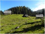 15
15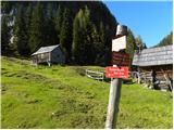 16
16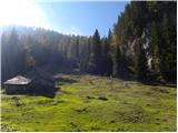 17
17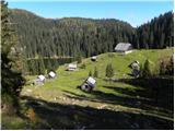 18
18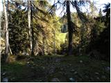 19
19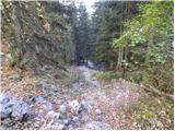 20
20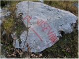 21
21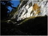 22
22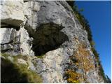 23
23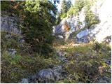 24
24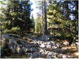 25
25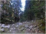 26
26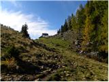 27
27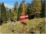 28
28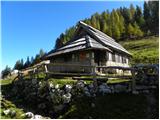 29
29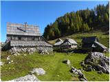 30
30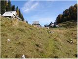 31
31 32
32 33
33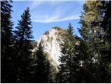 34
34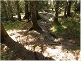 35
35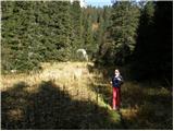 36
36 37
37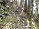 38
38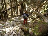 39
39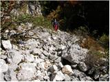 40
40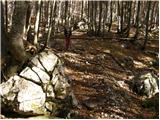 41
41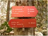 42
42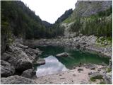 43
43
Discussion about the trip Planina Blato - Črno jezero
|
| B_U_R_I13. 04. 2013 |
Hello, what are the current conditions like? Next weekend we'll be in Bohinjska Bistrica and we planned to visit Črno jezero. Is there still any snow?
|
|
|
|
| simonz0r13. 04. 2013 |
Is there still some? In Karavanke at 1500m there's still 1.5m, in Julijci certainly some more. But it's all written in the snow conditions report. Good luck!
|
|
|
To post a comment you must log in:
If you do not yet have a username, you must first
register.