Planina Blato - Koča pri Triglavskih jezerih (via Prodi)
Starting point: Planina Blato (1147 m)
| Latitude/Longitude: | 46,31120°N 13,85010°E |
| |
Route name: via Prodi
Walking time: 3 h 15 min
Difficulty: easy marked way
Elevation gain: 538 m
Elevation difference along the route: 700 m
Map: Triglav 1:25.000
Recommended equipment (summer):
Recommended equipment (winter): ice axe, crampons
Views: 423.370
 | 6 people like this post |
Access to starting point:
From the Ljubljana-Jesenice motorway, take the Lesce exit and follow the road towards Bled and further towards Bohinjska Bistrica. Continue driving towards Lake Bohinj (Ribčev laz), where we reach a junction and continue right towards Stara Fužina. In Stara Fužina, at the junction by the chapel, turn sharply left onto the ascending road towards Planina Blato, Planina Vogar and Voje Valley. The road then brings us to the toll and parking fee collection point, and we follow it further to the next junction, where we continue left (right Voje). Then follow the road to the next junction (we drive for quite some time), where we turn sharply right towards Planina Blato (straight Planina Vogar). Follow this road to the parking lot before Planina Blato.
Route description:
From the marked parking lot in front of Planina Blato, return a little back and head onto the wide and initially also steep cart track, alongside which are signs for Planina pri Jezeru. After about ten minutes of ascent, we arrive at a marked junction, from where we continue left towards Planina pri Jezeru (slightly right Planina v Lazu and also the steep path towards Planina pri Jezeru).
Continuing on the less steep cart track that still leads through the forest, a little further on the left joins another marked path leading past Kosijev dom on Vogar, but we continue right and keep walking on the cart track. Higher up, the path leads through a narrow passage, then crosses quite steep slopes where there is a great risk of slipping in ice and snow, otherwise the path is not demanding. At the end of the steep slope, the aforementioned steep path joins unobtrusively from the right, the cart track turns left here and passes into the fairly cold Pungrat valley, where we ascend through mostly spruce forest. When the path levels out higher up, a path leading past Planina Vodični vrh joins from the left, but we keep slightly to the right direction and continue walking on the cart track, alongside which the forest begins to thin. Only a few minutes of easy walking follow and we step onto the pastures of Planina pri Jezeru, where on a small hill stands the Koča na Planini pri Jezeru.
At the hut, a path branches right towards Planina v Lazu, but we continue left from the hut and descend to a marked junction, where there are also a few shepherds' huts.
Choose the wider right path alongside which are signs for Planina Dedno polje and Koča pri Triglavskih jezerih (slightly left Pršivec, Planina Viševnik and Črno jezero).
We also continue ascending on the cart track, which is quite rocky in steep places, after about ten minutes of ascent we arrive at a point where a path over Krištofojca branches left towards Planina Viševnik, but we continue straight on the gradually less steep cart track that leads through gradually sparser forest. A few more minutes of easy walking follow on the path that later turns slightly right, when the path turns back towards the west we already reach the edge of Planina Dedno polje, from where a walk to the central part of the pasture follows, where by the shepherds' huts there is also a marked junction.
Bypass the shepherds' huts and dairy on the left side and continue straight towards Koča pri Triglavskih jezerih (right valley Za Kopico). From the pasture onwards we begin to ascend moderately, and from the left an almost unnoticeable path from the nearby hunting hut joins us. A little further the path leads past another branch of the path towards Planina Viševnik (path along Griva (1758 m)), and in the next few minutes we arrive at the upper edge of the vast Planina Ovčarija, from where a beautiful view opens up to the Bohinj-Tolmin mountains, sometimes called Lower Bohinj mountains. From here a short descent follows and we arrive at a junction on the northeastern part of the pasture.
Continue slightly right towards Koča pri Triglavskih jezerih and Male Tičarice (left Planina Viševnik), and the path soon splits again.
From the junction follow the signs for the path via Prodi (right path over Štapce) and after a few more minutes arrive at a beautiful vantage point from which a nice view opens to the Komna plateau and Bohinj-Tolmin mountains.
Here the path turns right and from the plateau passes onto steep grassy slopes across which we descend transversely to the left in a moderate descent. Lower down the path enters dense forest, the slope becomes less steep, and we steeply ascend for a short time further on. A few minutes further we reach a marked junction above Lopučniška dolina, where we join the path starting at Koča pri Savici, or the path leading past Črno jezero.
Continue straight towards Koča pri Triglavskih jezerih (left Koča pri Savici) on the path that gently ascends further, bringing us to a point from where a nice view of Dvojno jezero opens. Here we also pass a branch to Ruski grob, then the path leads along the right, eastern side of Dvojno jezero, where from the right joins the path starting at Planina Blato, namely the path over Štapce.
Continue straight and when we leave the lake shore, only a few dozen steps of easy walking separate us from Koča pri Triglavskih jezerih.
Starting point - Planina pri Jezeru 1:00, Planina pri Jezeru - Planina Dedno polje 0:30, Planina Dedno polje - Planina Ovčarija 0:45, Planina Ovčarija - Prodi 0:15, Prodi - junction above Lopučniška dolina 0:30, junction above Lopučniška dolina - Dvojno jezero 0:10, Dvojno jezero - Koča pri Triglavskih jezerih 0:05.

The trip can be extended to the following destinations: Dom na Komni,
Planina Lopučnica,
The lake Jezero v Ledvicah (1 h),
Rušnata glava,
The lake Zeleno jezero,
The lake Rjavo jezero,
Zasavska koča na Prehodavcih,
Mala Tičarica,
Velika Tičarica,
Koča na Doliču,
Kopica,
Vodnikov Vršac (Vršac nad Zadnjico),
Čelo,
Mala Zelnarica,
Malo Špičje,
Velika Zelnarica,
Vrh Hribaric,
Veliko Špičje (2 h 30 min),
Vršaki (Vzhodni vrh),
Kanjavec,
Triglav
Photos:
 1
1 2
2 3
3 4
4 5
5 6
6 7
7 8
8 9
9 10
10 11
11 12
12 13
13 14
14 15
15 16
16 17
17 18
18 19
19 20
20 21
21 22
22 23
23 24
24 25
25 26
26 27
27 28
28 29
29 30
30 31
31 32
32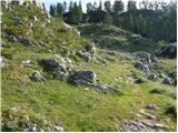 33
33 34
34 35
35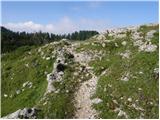 36
36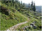 37
37 38
38 39
39 40
40 41
41 42
42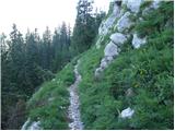 43
43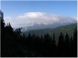 44
44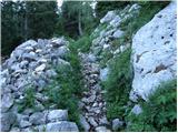 45
45 46
46 47
47 48
48 49
49 50
50 51
51 52
52 53
53 54
54 55
55 56
56
Discussion about the trip Planina Blato - Koča pri Triglavskih jezerih (via Prodi)
Show older messages
|
| mukica6. 12. 2007 |
For me the most beautiful trail in our mountains, usually we do a loop via Štapce to the 7j hut back via Prode or vice versa.
|
|
|
|
| Gost7. 12. 2007 |
This is really one of the nicer trails here. The only thing that bothers me is the expensive toll to Planina Blato.
|
|
|
|
| Gost10. 12. 2007 |
Really a nice tour. Wondering if anyone has hiked this path in recent days, how much snow and if the path is trodden. thanks and best regards. K.
|
|
|
|
| velkavrh1. 08. 2008 |
Was here today - wonderful weather, lots of visitors - lots of foreigners. For me the shortest and also most beautiful path to the Triglav Lakes. The path is exceptionally enhanced by stops at Planina Pri Jezeru with a nice hut and at Planina Dedno Polje. It impresses especially with the unusual construction of shepherd huts. Highly recommend a visit. The path is not strenuous, maybe a bit long, but there are so many resting spots along the way that it's worth it.
|
|
|
|
| zarja13. 08. 2008 |
I'm interested if the described path to Triglav Lakes is steep? And also, is it possible from Pokljuka to Triglav Lakes, can someone describe the path?
Thanks.
|
|
|
|
| Tadej13. 08. 2008 |
The described path is not steep.
It is also possible from Pokljuka, but the path is at least 8 hours one way. The path goes like this: Pokljuka - Velo polje - Mišeljski preval - Lazovski preval - planina v Lazu - planina Dedno polje - planina Ovcarija - koča pri Triglavskih jezerih. There are many ascents and descents on the path.
|
|
|
|
| zarja13. 08. 2008 |
Thanks Tadej. I think I won't go from Pokljuka and will choose the described path instead.
|
|
|
|
| Stolar13. 08. 2008 |
Has anyone walked the path from Blato over Črno jezero to the double lake? Is the path suitable for children aged 10 to 12?
|
|
|
|
| Filip&Jakob13. 08. 2008 |
Last week we as a family with an 8-year-old walked the path from Koča pri Triglavskih jezerih to Planina Blato via Štapce without problems, which is described as a demanding marked path probably due to about 20 meters of secured path over the ridge. The path via Prode is marked as easy - so this path will be suitable for children too, of course with proper equipment (footwear!) and a bit of motivation! Overall we met quite a few families on the path, even with smaller children. In nice weather these paths are more than wonderful!
|
|
|
|
| Stolar14. 08. 2008 |
Thanks, I actually meant the path from Planina Viševnik to Črno jezero, if it's exposed anywhere.
|
|
|
|
| Joshua7631. 07. 2009 |
Hello.
Can someone tell me which path to the lakes is easier?
- Planina Blato - Koča pri Triglavskih jezerih (via Prode)
or
- end of the road at Vogar - Koča pri Triglavskih jezerih
As far as I know both paths are easy and in principle I wouldn't complicate it. The problem is, I'd like to take my dog along. I'm interested if both paths are normally passable or if I might encounter some ascents or descents somewhere that wouldn't be passable for the dog.
Best thanks for the reply.
A
|
|
|
|
| ben31. 07. 2009 |
Both paths join a little below Planina pri Jezeru. Across Dedno polje and pl. Ovčarije across the scree fields there is no such place that a dog couldn't manage.
LP B
|
|
|
|
| AndrejK31. 07. 2009 |
Joshua76, here are some more precise instructions. The parking lot at pl. Blato and the end of the road at Vogar are not the same. There are quite a few kilometers in between. In my estimation about 5. So, if you park at Blato, you go to 7J via Planina pri jezeru, Dedno polje, Ovčarije and then via Prode to 7J. If you drive to the end of the road at Vogar, you have the option via planina Viševnik to Ovčarije and onward or the other option ascent to Pršivec and then via Planina Viševnik to Ovčarije and via Prode to 7J. Happy and steady steps to yours.
|
|
|
|
| Joshua764. 08. 2009 |
Andrej thanks. I went directly via Planina pri jezeru. Beautiful experience. On the return I chose the path over Štapc, which given that I was with the dog wasn't exactly the easiest. But what can we do, we learn from mistakes, right?
Thanks again, Aljoša
|
|
|
|
| MajaM5. 08. 2009 |
I also plan to go to Planina Blato and would take the dog too. Considering that, Joshua, you have the freshest experience, advise where we should head with the golden retriever?
|
|
|
|
| urshy6. 08. 2009 |
I need a CONCRETE tip from those who have already walked this path from pl. Blato.
Of course, to the hut at Triglav Lakes we would go for the first time with someone who is not used to hills, but really wants to go. The problem is that the path over Komna, which is very nice physically and time-wise he won't manage, because it's too long (if here it's a good three hours to walk, for this path we will already need at least 4.5 hours minimum!). The path over Komarča is automatically out for him, because it's completely out of his league.
So I would really need frank words on how steep this path is, crumbly, how the descent is (you can compare with the path to Komna, final ascent to Kamniško sedlo, Rombon, etc.). I would need one comparison.
And also data on how much of the path is over scree (crumbly), is there any exposed section (even short)? In short as many details as possible so we can better assess if it's suitable at all for such a beginner, because we have to adapt everything to the weakest link in the group.
|
|
|
|
| mukica6. 08. 2009 |
Concretely this is not a demanding path, first you ascend to Planina pri Jezeru, which is steep in places for a few meters. From the planina onwards you go again through shorter steeper sections 2-3 sections of 5-10 meters, nothing demanding or impossible, mostly steady ascent. Very nice path, easy rated 3.5 hours if you are not exhausted count 1 hour more. You need some fitness, you also have to return, unless you overnight. The path is more picturesque than to Komna and on certain sections almost flat. I recommend it, for me the nicest. Every year we go a couple of times, usually over Štapce and Prode back, in summer then to Kopica and through valley 7J past the hut to the starting point. You won't regret it, especially if the weather is nice.
|
|
|
|
| mukica6. 08. 2009 |
Specifically, this is not a difficult path; first you climb to Planina pri Jezeru, which is steep in places for a few meters. From the planina onwards, you go through shorter steeper sections, 2-3 sections of 5-10 meters, nothing difficult or impossible, mostly gradual ascents. Very nice path, easy, normed 3.5 hours if you're not tired, add 1 hour more. You need some fitness, as you have to return too, unless you overnight. The path is more scenic than via Komna and almost flat in some sections. I recommend it, for me the nicest. Every year we go a couple of times, usually via Štapce and Prode back, in summer to Kopica and via dolina 7 J past the hut to the start. You won't regret it, especially if the weather is nice.
|
|
|
|
| urshy6. 08. 2009 |
Thanks for the explanation. The path via Komna is out of the question. When we went alone, we walked over 5 hours with breaks, I can't even imagine how long it would take if we went on this path with him. 
The problem is not so much fitness, but lack of experience hiking in mountains, and a bit of clumsiness too. We'll go from Planina Blato, I hope it won't be too long overall.
|
|
|
|
| laraa14. 09. 2009 |
Hello!
End of the month I'd like to go along this path to the hut at Triglav Lakes and then overnight there. I'm wondering if it's safe to leave the car overnight at the parking lot above Planina Blato.
Thanks!
|
|
|
|
| mukica14. 09. 2009 |
So far it has been completely safe, we've left it there many times and no issues,
|
|
|
|
| laraa14. 09. 2009 |
Mukica, thanks for the info. Already looking forward to the nice hike, if the weather is OK.
|
|
|
|
| laraa5. 10. 2009 |
Yesterday I went along this path to the hut at Triglav Lakes, then also to the lake in Ledvice, and back via Štapce and planina Viševnik. It was fantastic, weather and views divine!
|
|
|
|
| mia5. 10. 2009 |
I'm wondering if there are any larches along this path and if they are already turning yellow. Thanks
|
|
|
|
| dogna5. 10. 2009 |
I prefer the path via Štapce. A week ago the larches were just starting to turn yellow.
Mostly there are only larches. When going over planina Ovcarija be careful of the chamois and
their whistling. Return can be via Prode and planina Viševnik or to Crno jezero and planina Viševnik. Lots of choices. The larches will be most beautiful now. Wishing you much enjoyment.
|
|
|
|
| keber15. 10. 2009 |
Larch trees have just started yellowing, in a week or two it will be much more colorful. Warning: despite closed huts above Bohinj they still collect usurious toll for road to Planina Blato, at least this weekend. Also unclear why hut at Planina Jezero is closed (at least weekends not needed), many hikers here this weekend, parking as full as summer.
|
|
|
|
| dogna6. 10. 2009 |
A little before 7am no parking fee collected.
|
|
|
|
| EUGEN6. 10. 2009 |
Road to Planina Blato, 10.00€.
4.10.2009
|
|
|
|
| JusAvgustin6. 10. 2009 |
Not parking but road toll. What, no vignettes introduced? I support but only for foreigners and "non-locals".
|
|
|
|
| laraa7. 10. 2009 |
I was up there on Sunday, 4.10. At 7am I drove through Stara Fužina and onwards, and there was no one anywhere collecting parking fees. Maybe it was too early.
|
|
|
|
| rjudnic8. 10. 2009 |
geolog79 why should one from Bohinj have it for free, one from Bled or Bela krajina would pay, that's discrimination then
real locals have it free anyway, because the collectors know you
|
|
|
|
| zippo8. 10. 2009 |
I think they stop collecting the toll around October anyway, because earnings are already less than costs
|
|
|
|
| stefanb9. 10. 2009 |
According to information obtained from the toll collector on 4.10.09, they will collect toll until the end of October.
|
|
|
|
| lanko28. 04. 2010 |
Has anyone walked towards the Triglav Lakes recently? Is there still a lot of snow and is the path trodden?
|
|
|
|
| Iguana30. 07. 2010 |
I'm heading to the Koča pri Triglavskih jezerih. Nowhere have I found a description via Lopučniška dolina. I'd go from Planina Blato, over Viševnik, Dol pod Stadorjem and Lopučniški dolina. If anyone has walked this route, I'd appreciate a comment on what the path is like.
Thanks everyone for the help. Best regards from the mountains
|
|
|
|
| Iguana1. 08. 2010 |
Yesterday I did the trail to the 7 lakes. Pleasant trail. Few hikers. I didn't return via Lopučniški or over Štapce, my companion was tired, so we went back the same way, only at Planina Ovčarija I convinced her to go to Planina Viševnik. Just above the planina there's an awkward bit, a wire rope advisable, at least on descent.
|
|
|
|
| alesvrscaj4. 07. 2011 |
How far is it from Bohinj to Planina Blato (time, km) and what is the road like and the toll this year (still 10€?)
|
|
|
|
| _sandra_21. 08. 2011 |
I went to Triglav Lakes last week (14.8.) and drove a good half hour to Planina Blato. It's still 10 euros and there was terrible traffic up, I barely got some space for the car The path is great, it was my first time, so maybe that's why it excited me even more, the lakes are beautiful, so I recommend it, even to those less fit, because there's some ascent then flat. When I arrived at Koča pri Triglavskih jezerih I had a small snack, then went on to see the other lakes. Definitely I'll repeat it sometime 
|
|
|
|
| katty22. 08. 2011 |
I was also on that path that Sunday, 14.8. We went through Štapce , then climbed to Mala Tičarica and Zeljarica , then climbed to Mala Tičarica and Zeljarica . I wanted to go to Prehodavci... and we did. There were quite a few people, apparently all beds were occupied. We continued towards the Seven Lakes. Since I knew the path from Prehodavci to the Seven Lakes quite well, I knew a looooong way awaited me . I wanted to go to Prehodavci... and we did. There were quite a few people, apparently all beds were occupied. We continued towards the Seven Lakes. Since I knew the path from Prehodavci to the Seven Lakes quite well, I knew a looooong way awaited me . Along the way, we met many hikers, both Slovenian and foreigners. As Sandra already said, the path is quite easy and I recommend it to anyone who is not super fit. After 11 hours of walking, we were pleasantly tired, but the path over Prode to Ovčarija, Planina Laz, Dedno polje, Planina pri jezeru, and Planina Blato awaited us, where the car was waiting. The path over Prode tired us even more, as we were already sufficiently tired. In the end, we were really glad to have safely reached the car. . Along the way, we met many hikers, both Slovenian and foreigners. As Sandra already said, the path is quite easy and I recommend it to anyone who is not super fit. After 11 hours of walking, we were pleasantly tired, but the path over Prode to Ovčarija, Planina Laz, Dedno polje, Planina pri jezeru, and Planina Blato awaited us, where the car was waiting. The path over Prode tired us even more, as we were already sufficiently tired. In the end, we were really glad to have safely reached the car.
I would definitely repeat the path, as I hoped for as many stamps as possible, but unfortunately they didn't have them in either hut. (There is a stamp at the top of Tičarica and Zeljarica, but no ink pad attached, so I recommend taking a cloth with you). I'll repeat part of the path from Prehodavci to the Seven Lakes this weekend, as I'll climb Triglav for the third time.
As for parking, we were lucky not to pay anything, as we arrived at Planina Blato around 6 am, and returned at 20:00 . I agree, if you're not early enough, you definitely won't have anywhere to park your steel horse. The parking lot was really packed, even along the road there were lines of cars. . I agree, if you're not early enough, you definitely won't have anywhere to park your steel horse. The parking lot was really packed, even along the road there were lines of cars.
|
|
|
|
| _sandra_22. 08. 2011 |
Next time I will also go earlier, but since I'm from Lj. (Ljubljana), I'll have to leave home even earlier I was later because I had a room reserved in Koča pri Triglavskih jezerih anyway, so except for parking, I didn't miss anything
|
|
|
|
| Jonny_29. 02. 2012 |
Who has last walked around here? Can you get to Planina Blato by car? What's the path to the hut like - is there a track made?
|
|
|
|
| sodnick6. 03. 2012 |
Same question. Does anyone know how much snow is still on this path?
|
|
|
|
| maateja6. 03. 2012 |
The day before it was posted in the Current conditions section, under Sedmera jezera, exactly this path from Blato via Prode to Koča pri Triglavskih jezerih.
|
|
|
|
| ben6. 03. 2012 |
on Saturday we were on this path. Snow about a meter, to Planina pri jezeru fine tracks, from there only with snowshoes or skis. Crossing over Prode bare, in the forest snow again. In summary: best to go with skis or snowshoes although even with the latter sometimes sink to a...
LP B
|
|
|
|
| Jonny_7. 03. 2012 |
ben, thanks for the good description
|
|
|
|
| sonchek28. 08. 2012 |
what about the road to Planina Blato? is it asphalted?
|
|
|
|
| Alfista28. 08. 2012 |
Almost completely asphalted and it's nice to see where the toll money goes. Commendable!
|
|
|
|
| Enka28. 08. 2012 |
The road is great, no worries. We expected an OK road and were pleasantly surprised .
|
|
|
|
| sasajo8. 10. 2013 |
Can you get to the hut in 3 hours with a light backpack, and is the hut still open?
Thanks in advance for answers
|
|
|
|
| BlazG15. 10. 2013 |
This summer I visited it twice, the road surprised me too, excellent. Can be hiked under 3 hours no problem, path super, gets nicer closer to the goal! Will return, next time in snow. GPS track if anyone needs: http://www.strava.com/activities/73078696
|
|
|
|
| MONIK8. 06. 2014 |
Yesterday we first headed from Planina Blato to Mala Tičarica over Štapce and then to Koča pri Triglavskih jezerih. Still some light snow, but no big deal. At Triglavskih jezerih we missed the stamp. But excellent hike, sunny weather and wonderful views
|
|
|
|
| gbecan27. 02. 2015 |
Does anyone know what the conditions on the path are like, is there a lot of snow???
|
|
|
|
| salewa8910. 04. 2015 |
Does anyone know what the path is like? Is there a lot of snow?
|
|
|
|
| ammmt1. 06. 2016 |
Does anyone know if there is still snow on this trail?
|
|
|
|
| srecko581. 06. 2016 |
The trail from Planina Blato, Jezero, Dedno polje, Ovcarija, over Prode, hut at the Seven and back over Štapce is passable without snow.
The trail Dedno polje - Planina Laz still has some compacted snow, need to watch the markers.
Did the trail on Saturday. Wonderful. Good luck.
|
|
|
|
| smatjaz1. 06. 2016 |
ummm, I was on Sunday exactly on this trail so first hand, snow is just enough to cool you pleasantly in the heat....... , everywhere normally passable without "winter tires and chains", only occasionally in some depressions especially just before Štapce it sinks a bit due to rotten snow, so you can expect slightly wet pants, shorts not yet. Hut open only at the pasture by the lake, for the hut at 7 lakes I don't know. and lots of enjoyment. we exercised here http://www.hribi.net/gpszemljevid.asp?id=575
|
|
|
|
| ammmt2. 06. 2016 |
Thanks to both. I'll definitely go, just this weekend thunderstorms are forecast too...
|
|
|
|
| Simona928. 06. 2017 |
Can dogs overnight in the hut?
Thanks
|
|
|
|
| Enka28. 06. 2017 |
A few years ago when we asked, they offered us sleeping with dogs in the winter room. Later we decided to leave the dogs at home, so we didn't try it. Call and ask!
|
|
|
|
| pikica128. 06. 2017 |
No need to call, there's a sign on the door that dogs are not allowed entry to the hut. My little dog stood
on those steps in front of the entrance door and waited for me while I was putting the stamp in my booklet.
The stamps are right at the entrance when you step into the hut, and I was immediately informed that dogs are not allowed in the hut. It seemed really silly to me, the dog is standing in front of the door and they're already panicking.
|
|
|
|
| Simona929. 06. 2017 |
OK thanks but what a pity
|
|
|
|
| slamca29. 06. 2017 |
Come on people for God's sake, don't you get it? We have a dog at home and it shouldn't sleep where people do - not in the bed, bedroom...., it has its own space. Start treating a dog as a dog and not a substitute for a friend - girlfriend, not to say even a child.
|
|
|
|
| Enka29. 06. 2017 |
I still suggest you ask (what does it cost you?!). Because the winter room is a completely separate facility and has nothing to do with what pikica1 writes about.
|
|
|
|
| korl29. 06. 2017 |
Yeah, some dogs sleep in the bed or roll on the couch and eat from the same plate. It's an individual matter, how someone has it arranged at home, it doesn't bother me at all.
But it bothers me a lot that I have to cover myself with a blanket that a dog was covered with. And regardless that dog lovers will jump into the air, because probably people have done who knows what under that blanket already... So what, but I also won't go sleep in a dog kennel. Dogs should be where they belong, and people too.
|
|
|
|
| slamca29. 06. 2017 |
@korl, exactly like that. There must be order
|
|
|
|
| blazzm30. 06. 2017 |
Call and ask what the options are.
Dogs are not allowed in the hut, but arrangements can often be made. Last year's warden loved dogs very much.
|
|
|
|
| donat1. 07. 2017 |
The dog won't die if it spends the night in the woodshed or under some shelter by the hut, I think there's no problem with that in the hut.
|
|
|
|
| gmeta7. 08. 2018 |
I'm wondering, is it appropriate in August to go on this path (Planina Blato, Planina Jezero, Prode, Sedmera jezera) in Adidas sneakers?
|
|
|
|
| John7. 08. 2018 |
They must be Adidas sneakers, i.e. ADIDAS sports shoes, and if it's still as hot as these days, even in flip-flops but only ADIDAS brand. Have a safe journey and steady steps
|
|
|
|
| mirx7. 08. 2018 |
I walked this path a week ago in trekking Adidas  . .
|
|
|
|
| John8. 08. 2018 |
On Saturday, some tourist (I assume Dutch, maybe Scandinavian) "climbed over" Komarča in flip-flops, somehow equipped like I am for the beach (flip-flops, shorts, t-shirt), except I take a couple of liters of water to the beach. Well, the tourist at Komarča was also asking for the way ahead to Pršivec. I assume she made it without major issues, since I haven't seen any reports of a rescue operation in those parts. So obviously, even "equipped" like that, one can climb quite far. The main question is how sensible that is or when something can go wrong, literally, or even worse.
|
|
|
|
| iUnknown8. 08. 2018 |
@John That's just proof that: everything is possible if you want it
|
|
|
|
| pinkerton8. 08. 2018 |
The late Igor used to photograph the feet of some hikers in opanci, but in the end mentioned that they never had to rescue any such. Maybe because opanci wearers have a better sense of how far they can go, and those who slip are mainly those with worn-out hiking boots.
|
|
|
|
| iUnknown8. 08. 2018 |
Oh no, don't mention those worn-out hiking boots.
This Saturday I was in the mountains and on the way back I overtook a real hiker in hiking boots. But they didn't look like from Lidl or Decathlon. And that hiker was slipping every few steps because they kept sliding. For me, in contrast, it only slipped slightly a couple of times on the whole path even though I carried a quite heavy (about 15 kg) 70-liter backpack and was wearing low La Sportiva Ultra Raptor. Those are very good for me because they grip very well. The problem is they don't last long.
By the way, they found Ötzi at 3210m in South Tyrol, who also didn't have any hiking boots and didn't die of that
|
|
|
|
| pinkerton8. 08. 2018 |
I didn't mean cheap stuff, but more like 10-year-old, once excellent hiking boots that have completely worn treads, but it's a shame to replace them
|
|
|
|
| KJ8. 08. 2018 |
But they are so well broken in!!
|
|
|
|
| mirank8. 08. 2018 |
Yeah, they are worn out, but the rubber hardens over time and doesn't grip anymore. Those school ones only for the field...
|
|
|
|
| bpigor26. 07. 2019 |
Hello.
I plan next weekend via Planina Blato to Triglav Lakes with my son (14)
Please provide information on some circular tour back to Planina Blato.
Thank you
|
|
|
|
| John26. 07. 2019 |
#bpigor, here are variants...planina Blato, planina Jezero, Dedno polje etc..to Triglav Lakes. You return to planina Jezero and from there, planina v Lazu to Blato. But there are other variants.
|
|
|
|
| bpigor30. 07. 2019 |
Thanks John
|
|
|
|
| Enka30. 07. 2019 |
I recommend going there via Štapce (https://www.hribi.net/izlet/planina_blato_koca_pri_triglavskih_jezerih_cez_stapce/1/133/109 ), and returning via this path. On the way back, you can turn right at Planina Ovcarija towards Planina Viševnik, from which you descend directly to Planina pri jezeru. I also recommend the "detour" via Planina Blato if you are not too tired.
|
|
|
|
| glorija20. 09. 2019 |
Hello, I also used the free bus from Srednja vas, paid 4eur for parking for the whole day and took it to Planina Blato. Went to Sedmerih via Planina Jezero where in the hut the lady serving made it clear that we were unwanted with backpacks and spread bad mood around.. I wonder, do I really not know how to behave in a hut when I enter with a backpack? Of course there was no crowd.. Just asking, as it was the first time I encountered such a case.. We continued the path over the wonderful Dedni vrh and at the junction continued to Prode.. the path was very nice and varied, it didn't drag on at all as some say.. at the hut we chatted with a friendly gentleman who was serving and decided to continue via Štapce. There a ladder and cables surprised us a bit because we didn't know about it. We overcame that short distance and returned via this circular path back to Planina Blato. It was a really wonderful day with beautiful views.
|
|
|
|
| bbugari120. 09. 2019 |
"via Planina Jezero where the lady serving made it clear how unwanted we were with backpacks and spread bad mood around.. I wonder do I really not know how to behave in the hut when I come with a backpack?"
This will soon become the official form in huts. In Ribniška koča it's no longer allowed to eat from backpack (at least that's what it says)...
Will someone (PZS) do something about it, or probably not?
|
|
|
|
| Buha20. 09. 2019 |
In the Erjavčeva hut on Vršič, you are also not allowed to eat or drink your own drinks.
|
|
|
|
| felix20. 09. 2019 |
PZS should gradually define which huts are still alpine huts and which are private. Abroad, in some huts you can eat your own food, but you have to pay a surcharge.
|
|
|
|
| bo_zl20. 09. 2019 |
Let's look at it from the other side. Mountaineering associations need to earn for hut renovations and much more. And if most people ate and drank from their backpacks, they would earn very little. If the hut is rented to a private person (s.p. or d.o.o.), then it's like bringing food and drinks to a private restaurant. And it seems to me that since most people only go on day trips to the mountains, most pack everything possible in their backpacks. I happily drink and eat what the hut offers.
|
|
|
|
| rajko002820. 09. 2019 |
felix-abroad they also offer food that you won't get in many restaurants here-and that for the price of our goulash (10-12€. and at 4 am they brew coffee and prepare breakfast, at Planika at 4 pm I couldn't get food because the cooks need to rest sic. bobo zl-as long as I pay 6€ for a liter of Radenska, I'll carry it with me despite PZS instructions that they should charge me 1€ for drinking in the hut. Now I'm just waiting for them to set up a barrier and for me to pass for free only if I hire a guide.
|
|
|
|
| marjetap20. 09. 2019 |
I have a bad experience with food at Planika, there was no meat in the meat jota, I brought my sleeping bag, yet I had to pay for bedding - and so much propaganda and debate about this bedding. Sanitation is a chapter of its own - especially the outdoor WC, now in autumn when it's dark at 7 pm, they only open the indoor WC with normal lighting at 10 pm. In short, they won't see me again.
|
|
|
|
| bbugari120. 09. 2019 |
This year I slept (after many years) at the 7J highway. I get up at six in the morning (some even earlier) and - kitchen closed (locked!), no tea or coffee, it opens at 7...
Previously, you couldn't wake up before the caretaker...
Have things changed so much in recent years, or am I becoming very conservative?
Soon we'll only have hotels and outdoor destinations instead of mountain huts.
|
|
|
|
| alba2121. 09. 2019 |
@bbugari1 - You are not conservative, the mentioned mountain station is no longer what it used to be. Instant tourism of course...Otherwise choose Koča na Prehodavcih, if you're in those parts, it didn't become the highest mountain hut 2019 for nothing. Completely different story than down there.
|
|
|
|
| glorija22. 09. 2019 |
Ugh.. here it wasn't even about food from the backpack.. we just stepped into the room (two steps into the room)... of course, to sit down and order something to eat and drink.. but there were only two guests at one table in the whole room.. also my friend who hikes a lot with her husband said how the other employees are also in a bad mood upon arrival.. it really makes me want to vomit... Whoever is not for working with people, shouldn't do it.. I worked 30 years with customers, if I behaved like that I would fly out of the job that very minute as long and wide as I am...
|
|
|
|
| capraibex22. 09. 2019 |
We would file a complaint with PZS, or those responsible for this hut. In the recent time there are more such cases.
|
|
|
|
| darinka422. 09. 2019 |
You had bad luck. A couple of days ago I slept in the emergency shelter at Špička and we all felt very comfortable. Friendly girl. In the morning she got up at 6 to prepare breakfast for us. Not everything is so bleak. Last year also a pleasant couple up there. The year before Fux legend.
|
|
|
|
| jax22. 09. 2019 |
rajko0028
20.9.2019 felix-v abroad, they also offer food that you won't get in many restaurants here - and that for the price of our goulash (10-12€). But at 4:00 they brew coffee and prepare breakfast on Planika, but at 4 pm I couldn't get food because the cooks need to rest, sic. bobo zl - as long as I pay 6€ for a liter of Radenska, I'll carry it with me despite PZS instructions that they must charge me 1€ for drinks in the hut. Now I'm just waiting for them to put up the barrier and for me to pass for free only if I hire a guide.
Let me mention that this year I experienced the same at Artur von Schmid Haus under Säuleckom. Hut nice, tidy, also good food, but breakfast at seven. Damn it, that's how it is. Apparently they go from that (after all they can claim the same at Sedmerih or Planika), that there are no mountains nearby that would really require an early start. Those rare ones who have a longer traverse tour planned have to manage, of course. Definitely a minus, but not limited only to Slovenia ...
|
|
|
|
| felix24. 09. 2019 |
This topic should actually be somewhere else. I just stated the facts, but I certainly do not agree that you can't eat your own food in the hut. As someone already mentioned - the Ribniška koča was leased by our society to a private individual who prohibits eating own food in the hut - but as a society we can't do anything about it. For example, in the Dolomites a week ago, we arranged for breakfast an hour earlier than the schedule at a private hut.
Regards
|
|
|
|
| bbugari124. 09. 2019 |
"Ribniška koča was leased by our society to a private individual who prohibits eating own food in the hut - but as a society we can't do anything about it."
Isn't there any law, regulation, decision etc. at the PZS level that overrides such a tenant's prohibition, of course if it's a mountain hut?
|
|
|
|
| Aktem29. 05. 2020 |
Hey, has anyone been up there recently? Given that there's still snow in places, it might still be present on some sections here too?
|
|
|
|
| mili29. 05. 2020 |
We went on this path on Thursday. No snow left anywhere, the path is wonderful, lots of flowers along the path. The path from Planina Blato is also dry, no forest workers could be heard.
|
|
|
|
| Aktem29. 05. 2020 |
Many thanks
|
|
|
|
| Matt78919. 09. 2020 |
Yesterday my girlfriend and I went on this trail and it's really awesome. When we got back and were changing at the car, a cute little fox appeared a meter behind my back. It was very curious, not afraid at all, no signs of aggression, no foam around the mouth. In between it scratched itself a bit, I felt like I had my own dog there. I made a mistake by giving it the rest of the apple and it happily ate it. Then it sniffed around the car and headed towards my 2-week-old Salomons. I loudly told it, leave that and look at this thief grabbing the shoe and off into the bushes. I couldn't believe it. My girlfriend almost died laughing. I went after the fox into the forest, of course didn't find the shoe. It was slowly getting dark, cloudy, and that model of Salomons is dark green so every waving branch from afar looked like it could be the shoe. I searched the terrain multiple times, but of course didn't find the shoe. The little rascal then came back to the car once more to see if I had anything else to eat. Obviously the shoe didn't smell as good to it as it first thought :-D. So folks, watch your belongings, lock the car doors, if you spot it don't feed it or something might disappear :-D Probably I'm not the only one who fed it, as it seemed quite accustomed to humans.
|
|
|
|
| madeira19. 09. 2020 |
On Tuesday 15.09. I also had the parking lot at Planina Blato as starting point. When I returned to the car, as soon as she heard me she came out of the forest and stood close to me. Just waiting for a treat. Like a dog. I photographed her, I'll attach the photo in the Animal Behavior thread. I was thinking of bringing dog or cat food next time. It must be a young fox, I never saw it last year, but this year already the second time.
|
|
|
|
| pikica119. 09. 2020 |
@Matt789 you made me laugh nicely
|
|
|
|
| mukica20. 09. 2020 |
Nice adventure, the little fox knows where it has to sniff only the poor thing how it will survive the winter when there are no hikers up at the parking lot
|
|
|
|
| chloek26. 01. 2021 |
Hello, I would like to know if this hike is complicated?
|
|
|
|
| Davorin2822. 01. 2022 12:19:36 |
Hello. Has anyone gone on this path at this time? How is the passability of the road to Planina Blato?
|
|
|
|
| exwannabe22. 01. 2022 20:09:19 |
Complete closure until further notice. It's winter. If you're lucky, you can only go sledding on the road.
And I hope you don't think this path is equally "simple" in winter as in summer.
https://promet.bohinj.si/
|
|
|
|
| ločanka24. 01. 2022 08:53:18 |
How is the parking lot for Korita Mostnice currently?
|
|
|
|
| exwannabe24. 01. 2022 15:37:32 |
All current info on parking is on the link above.
And yes, it's possible to park at the Vorančkojca parking lot (Stara Fužina).
|
|
|
|
| Davorin2827. 01. 2022 12:38:48 |
Exwannabe, no worries I know it's not as simple as in summer, I was just curious about the road. Thanks
|
|
|
|
| winni28. 01. 2022 10:20:01 |
Bohinjski veleumi have raised the toll to 15€ per day.
|
|
|
|
| exwannabe28. 01. 2022 14:21:56 |
Given the summer crowds it's probably still too little.
|
|
|
|
| turbo28. 01. 2022 15:30:56 |
Dobrač is 19.50€, but from mid-November to mid-April it's free (plowed to the top). Asphalt, parking lots, lots of info points along the road, viewpoints... You get a map, brochure and sticker, all included in the price And it can't happen that on one section you have to reverse on half the road width (the other half parked), if you meet another vehicle, as happens on the Vogar-Blato section 
|
|
|
|
| jaz28. 01. 2022 19:53:35 |
Nothing is free, I already paid 9 euros parking fee in December. Regards!
|
|
|
|
| Valgirt slo 10. 10. 2023 17:22:25 |
Hello.
Where is the SPP stamp when the hut is closed..?
Best regards.
|
|
|
|
| bistri12. 05. 2025 07:29:43 |
Has anyone been on this trail in the last few days? Any peculiarities?
|
|
|
To post a comment you must log in:
If you do not yet have a username, you must first
register.