Planina Blato - Planina Ovčarija
Starting point: Planina Blato (1147 m)
| Latitude/Longitude: | 46,31120°N 13,85010°E |
| |
Walking time: 2 h 15 min
Difficulty: easy marked way
Elevation gain: 513 m
Elevation difference along the route: 600 m
Map: Triglav 1:25.000
Recommended equipment (summer):
Recommended equipment (winter): ice axe, crampons
Views: 13.711
 | 3 people like this post |
Access to starting point:
From the Ljubljana - Jesenice motorway, take the Lesce exit and follow the road towards Bled and further towards Bohinjska Bistrica. Continue driving towards Lake Bohinj (Ribčev laz), where we reach a junction, continuing right towards Stara Fužina. In Stara Fužina, at the junction by the chapel, turn sharply left onto the ascending road towards Planina Blato, Planina Vogar and Voje Valley. The road then takes us to the toll and parking fee collection point, but we continue following it to the next junction, where we continue left (right Voje). We then follow the road to the next junction (we drive for quite some time), where we turn sharply right towards Planina Blato (straight Planina Vogar). We then follow this road to the parking lot above Planina Blato.
Route description:
From the marked parking lot in front of Planina Blato, return a little back and head onto a wide and initially steep cart track, marked for Planina pri Jezeru. After about ten minutes of ascent, we reach a marked junction, from where we continue left towards Planina pri Jezeru (slightly right Planina v Lazu and also a steep path towards Planina pri Jezeru).
Continuing on the less steep cart track that leads us further through the forest, a marked path joins from the left shortly ahead, leading past Kosijev dom on Vogar, but we continue right and keep walking on the cart track. Higher up, the path leads through a narrow passage, then crosses quite steep slopes where there is a high risk of slipping on ice and snow, otherwise the path is not demanding. At the end of the steep slope, the aforementioned steep path joins unobtrusively from the right, and the cart track turns left here and enters the rather cool Pungrat valley, where we ascend through mostly spruce forest. When the path levels out higher up, another path joins from the left leading past Planina Vodični vrh, but we keep slightly right and continue walking on the cart track, beside which the forest begins to thin. A few minutes of easy walking follow, and we step onto the pastures of Planina pri Jezeru, where the Koča na Planini pri Jezeru hut stands on a small hillock.
At the hut, a path branches right towards Planina v Lazu, but we continue left from the hut and descend to a marked junction where there are also a few shepherds' huts.
Choose the wider right path marked for Planina Dedno polje and Koča pri Triglavskih jezerih (slightly left Pršivec, Planina Viševnik and Črno jezero).
We continue ascending on the cart track, which is quite rocky on steep sections, and after about ten minutes of ascent, we reach a point where a path branches left over Krištofojca towards Planina Viševnik, but we continue straight on the gradually less steep cart track that leads us through increasingly sparse forest. A bit more easy walking follows on the path that later turns slightly right; when the path turns back towards the west, we already reach the edge of Planina Dedno polje, from where a short walk leads to the central part of the pasture, where there is also a marked junction by the shepherds' huts.
Bypass the shepherds' huts and cheese dairy on the left side and continue straight towards Koča pri Triglavskih jezerih (right valley Za Kopico). From the pasture onwards, we begin a moderate ascent, and a path from the nearby hunting hut joins almost imperceptibly from the left. A little further, the path passes another branch towards Planina Viševnik (path along Griva (1758 m)), and in the next few minutes, we arrive at the upper edge of the vast Planina Ovčarija, from where a beautiful view opens up to the Bohinj - Tolmin mountains, sometimes called the Lower Bohinj mountains. From here, a short descent follows, and we reach a junction in the northeastern part of the pasture. Here we can continue left towards Planina Viševnik and in a few minutes arrive at the shepherds' huts on Planina Ovčarija.
Starting point - Planina pri Jezeru 1:00, Planina pri Jezeru - Planina Dedno polje 0:30, Planina Dedno polje - Planina Ovčarija 0:45.

The trip can be extended to the following destinations: Planina Blato (4 h 45 min),
Dom na Komni,
Planina Lopučnica,
Koča pri Triglavskih jezerih,
Rigeljc ( 45 min),
Stadorski Orliči ( 45 min),
Vrtec ( 45 min),
The lake Jezero v Ledvicah (2 h),
Rušnata glava ( 35 min),
The lake Zeleno jezero,
The lake Rjavo jezero,
Zasavska koča na Prehodavcih,
Mala Tičarica (1 h 15 min),
Velika Tičarica (1 h 35 min),
Kopica (2 h 15 min),
Čelo,
Mala Zelnarica (3 h),
Velika Zelnarica,
Veliko Špičje (3 h 30 min)
Photos:
 1
1 2
2 3
3 4
4 5
5 6
6 7
7 8
8 9
9 10
10 11
11 12
12 13
13 14
14 15
15 16
16 17
17 18
18 19
19 20
20 21
21 22
22 23
23 24
24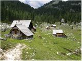 25
25 26
26 27
27 28
28 29
29 30
30 31
31 32
32 33
33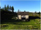 34
34
Discussion about the trip Planina Blato - Planina Ovčarija
|
| velkavrh1. 08. 2008 |
Was here today on the way to the hut at Triglav Lakes. The alpine pasture is quite large, but overgrown. It used to be very frequented, of which today only modest remains of barns and ruins remind us. The other shepherd huts are on the edge and not visible from the path to Triglav Lakes, except one hidden among trees and one in the middle of the pasture. No livestock was observed here today.
|
|
|
To post a comment you must log in:
If you do not yet have a username, you must first
register.