Planina Polog - Source of Tolminka
Starting point: Planina Polog (457 m)
| Latitude/Longitude: | 46,23800°N 13,72320°E |
| |
Walking time: 1 h
Difficulty: easy marked way
Elevation gain: 238 m
Elevation difference along the route: 238 m
Map: Julijske Alpe - zahodni del 1:50.000
Recommended equipment (summer):
Recommended equipment (winter):
Views: 42.328
 | 3 people like this post |
Access to starting point:
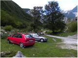
First, we drive to Tolmin, from there we follow the road in the direction of Zatolmin (we leave the main road at the traffic light). In Zatolmin, we notice the hiking signposts for Javorca, which direct us onto an ascending road towards Javorca. The occasionally quite narrow and in places precipitous road brings us, after approximately 8 km of driving, to a smaller intersection, where the road towards Javorca branches off to the left upwards. We continue straight, we follow the road only for approximately 100 m, and then we park at an appropriate place by the barrier.
Route description:
From the starting point, we continue on a macadam road (the road is closed to public traffic), which after a few minutes of easy walking brings us to the central part of the mountain pasture, where a few cottages stand. Behind the mountain pasture, the road becomes a little worse, and after a few minutes of further walking brings us to a junction, where the path to the mountain pasture Planina na Prodih branches off to the right (access to the mountain pasture is very interesting, as we have to cross the river Tolminka, which we do using a hand-operated cableway). We continue straight, and the road eventually turns into a cart track and higher up into a well-preserved mule track. The path then becomes somewhat steeper and leads us past two benches and higher past a fresh rocky outcrop (earthquake in Posočje 1998), to a grazing fence, over which we step onto the southern edge of the mountain pasture below Osojnica. Just a few meters further, the path splits into two parts. We continue along the right lower path, by which in a gentle descent we quickly arrive at the hunting hut at the source of the Tolminka.

The trip can be extended to the following destinations: Planina Dobrenjščica (1 h 45 min),
Kser (3 h 30 min),
Vrh Škrli (3 h 35 min),
Velika Montura (4 h 30 min),
Vrh Planje (4 h 30 min),
Bogatin (4 h 45 min),
Mahavšček,
Velika Baba (4 h 40 min),
Tolminski Kuk (5 h 15 min),
Batognica (5 h),
Vrh nad Peski (4 h 25 min),
Krn (5 h 45 min)
Photos:
 1
1 2
2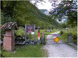 3
3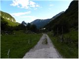 4
4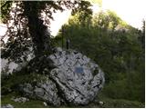 5
5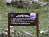 6
6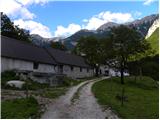 7
7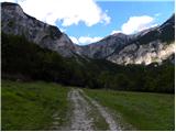 8
8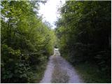 9
9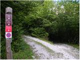 10
10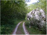 11
11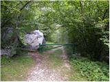 12
12 13
13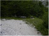 14
14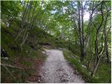 15
15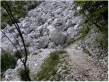 16
16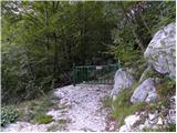 17
17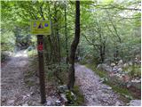 18
18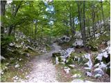 19
19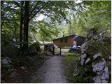 20
20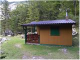 21
21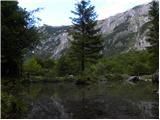 22
22
Discussion about the trip Planina Polog - Source of Tolminka
|
| Carpinus6. 07. 2013 |
Does anyone perhaps know the condition of the road from Tolmin to Planina Polog? I mean especially if it's quite eroded from rain for a car.
|
|
|
|
| lukec 115. 06. 2014 |
Super trip, back via the alpine pasture to Prodih
|
|
|
|
| franci na balanci17. 07. 2015 |
I'm wondering if the road to the parking lot under Javorca is passable for a 20-seat bus?
|
|
|
|
| tine.sl17. 07. 2015 |
The road is surely passable even for a larger bus, as it's relatively wide.
I don't know if there's any official prohibition for larger vehicles but I think there's no problem for a 20-seat bus.
|
|
|
|
| matzaj1. 11. 2015 |
Is the road after the September landslide already open?
|
|
|
|
| sh2. 11. 2015 |
On Saturday it was officially closed, now there should be another landslide under the road. The church at Javorca is also closed.
|
|
|
To post a comment you must log in:
If you do not yet have a username, you must first
register.