Sveti Jurij (Remšnik) - Sveti Pankracij (Radelca)
Starting point: Sveti Jurij (Remšnik) (685 m)
| Latitude/Longitude: | 46,62584°N 15,30018°E |
| |
Walking time: 1 h 15 min
Difficulty: easy marked way
Elevation gain: 215 m
Elevation difference along the route: 235 m
Map: Pohorje 1:50.000
Recommended equipment (summer):
Recommended equipment (winter): ice axe, crampons
Views: 413
 | 1 person like this post |
Access to starting point:
A) From the road Dravograd - Maribor, in the settlement Vas we turn left towards Remšnik. A few kilometers of ascent follow, and we follow the road to Remšnik, where we park on a parking lot below the church of St. Jurij.
B) From the road Maribor - Dravograd, in the settlement Brezno we turn right towards Remšnik and Brezni Vrh. We further follow the signs for Remšnik, where we park on a parking lot below the church of St. Jurij.
Route description:
From the parking lot below the church, in the direction of access to the starting point, we descend to the nearby crossroad, from which we continue straight. The path ahead leads us further past the chapel and we quickly arrive at the next crossroad, from which we continue straight towards Kapunar (left Vas). We continue past a few more houses, from which a nice view opens up back towards the church of St. Jurij, and the road then passes into the forest, through which we continue for a few minutes. When we leave the forest we go past a few more houses, and then we arrive at the farm Helbel, where the path splits.
We continue straight (we can also go right, the paths join higher at the homestead Zgornji Kočnik) and follow the blazes. Higher up we also follow the blazes, and turn-offs of the roads lead to the nearby homesteads.
At the homestead Zgornji Murn we reach the marked junction, where we join the path which leads from sv. Urban, and we continue straight, where we cross a strip of forest. After crossing the forest the previously mentioned path also joins from the right, which branched off from ours at the farm Helbel.
We continue on the upper road in the direction of sv. Pankracij and the stamp at Mravljak, along which we ascend for a short time, and then we go left onto a marked cart track, along which we ascend to the farm Mravljak, from which a nice view opens up towards the church of St. Pankracij.
After the farm we continue past the outbuilding on the path to sv. Pankracij, which brings us in a few minutes to the border ridge, where the Austrian path i.e. the path from the hut Kapunerhütte joins.
We continue slightly right, at first still a little downwards, a little after the chapel, in a minute of further walking we ascend to the church of St. Pankracij, from which a beautiful view opens up mainly towards Austria, and for an even more beautiful view we can in season ascend to the lookout tower.

Photos:
 1
1 2
2 3
3 4
4 5
5 6
6 7
7 8
8 9
9 10
10 11
11 12
12 13
13 14
14 15
15 16
16 17
17 18
18 19
19 20
20 21
21 22
22 23
23 24
24 25
25 26
26 27
27 28
28 29
29 30
30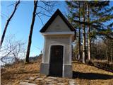 31
31 32
32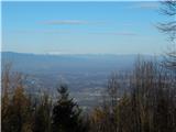 33
33 34
34 35
35
Discussion about the trip Sveti Jurij (Remšnik) - Sveti Pankracij (Radelca)
To post a comment you must log in:
If you do not yet have a username, you must first
register.