Untere Valentinalm - Monte Coglians (Hohe Warte) (via Wolayer See)
Starting point: Untere Valentinalm (1220 m)
| Latitude/Longitude: | 46,62250°N 12,92880°E |
| |
Route name: via Wolayer See
Walking time: 5 h 30 min
Difficulty: difficult marked way
Elevation gain: 1560 m
Elevation difference along the route: 1950 m
Map: Tabacco 9
Recommended equipment (summer): helmet, self belay set
Recommended equipment (winter): helmet, self belay set, ice axe, crampons
Views: 12.132
 | 3 people like this post |
Access to starting point:
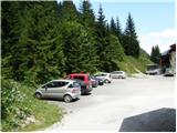
From Trbiž/Tarvisio we head onto the highway towards Videm/Udine. At Carnico, we leave the highway and first follow the signs towards Tolmezzo, then the signs for Austria and the mountain pass Pso di Croce Carnico / Plöckenpass. On the mountain pass, we descend to the Austrian side past the mountain hut Plocken Haus. Soon, the road towards the mountain hut Untere Valentinalm branches off to the left, where there is also a smaller parking lot.
Route description:
At the mountain hut, we head onto the mountain road following the signs for Ob. Valentinalm and Wolayer See. The road is quite flat and closed to public traffic. Soon we leave the road and head right onto a footpath, which later crosses the road several times and brings us to the hut Obere Valentinalm in less than an hour, from which there is a nice view of Rauchkofel (2460m) and the northern wall of the mountain Kellerspitzen (2769m).
From the hut, we continue on a well-marked footpath past the mountain pasture where livestock grazes in summer. At the end of the mountain pasture, the path turns a little to the left, where we begin to ascend through the valley below the mighty walls of Coglians. The path through the valley, which occasionally runs across grassy slopes and occasionally across slopes strewn with rocks and boulders, brings us to the junction at the saddle Valentin Torl (2238m) in about an hour. To the right the path leads to Rauchkofel, to the left a very demanding climbing path to Monte Coglians. We choose the middle path, which starts descending from the saddle and brings us to Lake Wolayer See in about half an hour, from where there is a very nice view of Monte Coglians and Monte Capolago. By the lake there is also the mountain hut Wolayerseehütte.
At the lake, we head left towards the Wolayer Pass, which is just a few minutes' walk away. From the pass, where there is the Rifugio Lambertenghi Romanin hut on the Italian side, we descend slightly and soon reach a junction, where we head left following the signs for Rifugio Marinelli (Sentiero Spinotti path); the right path leads down the valley to the Tolazzi hut. From the junction, we first cross scree beneath the western walls of Coglians for a short time, after which the path becomes much more demanding. With the aid of fixed protections and a ladder, we climb up an almost vertical narrow gully. Then the path ascends quite steep rocky slopes, where steel cables occasionally assist us. The path becomes a little gentler for a short time and turns slightly to the left, then steeply ascends rocky slopes again until we reach the grassy slopes on the south side of Coglians. The path becomes easier and soon joins the path from the Marinelli hut across meadows and scree. Here we begin ascending slightly slippery scree, which becomes quite steep in the upper part. In the final section, the path turns left and follows a steep ascent with some easy scrambling to the very panoramic summit.

Photos:
 1
1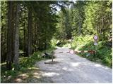 2
2 3
3 4
4 5
5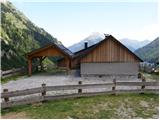 6
6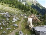 7
7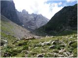 8
8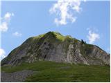 9
9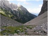 10
10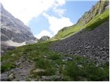 11
11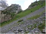 12
12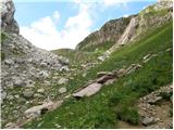 13
13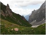 14
14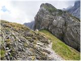 15
15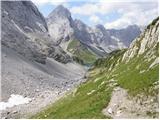 16
16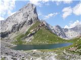 17
17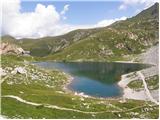 18
18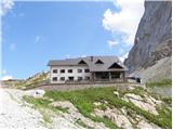 19
19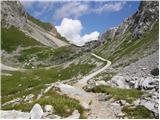 20
20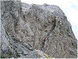 21
21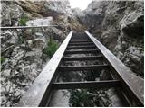 22
22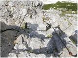 23
23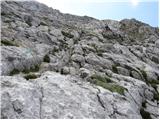 24
24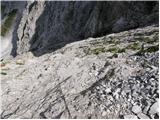 25
25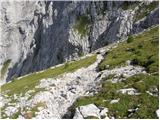 26
26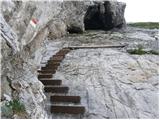 27
27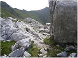 28
28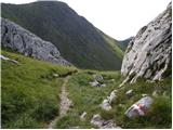 29
29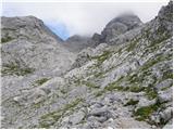 30
30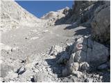 31
31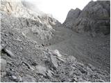 32
32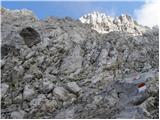 33
33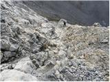 34
34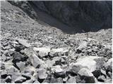 35
35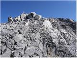 36
36 37
37
Discussion about the trip Untere Valentinalm - Monte Coglians (Hohe Warte) (via Wolayer See)
|
| VanSims8. 07. 2012 |
The Spinotti path is nice and fairly easy (but exposed) climb - the path to the very summit is laborious knee-grinding on scree! Poles don't help much uphill, but a lot downhill.
|
|
|
|
| dogna30. 03. 2013 |
Van Sims, this year I plan to go to the summit via this path. Do you recommend the Spinotti path solo complete? I'm also interested in the scree itself, can you compare it to some in our mountains? So far the most annoying scree for me was before the climbing ascent to Košutnikov turn from the Austrian side. Thanks for the reply and happy holidays.
|
|
|
|
| IgorZlodej30. 03. 2013 |
I don't know why the scree to the top of Coglians would be problematic, since there's a nice mule track leading up, only in the summit part do you need to grab the rock here and there. As for the "sentiero Spinotti" path, I think a via ferrata set is not needed, because there are few cables, and over the most difficult part there's a wooden staircase installed.
|
|
|
|
| mirank30. 03. 2013 |
In my opinion, for the ascent via the Spinotti path, the only recommended starting point is at koča Tolazzi, unless you're returning the same way, which seems completely pointless to me and a rather long tour. The Spinotti path joins the path past koča Marinelli (where you return to the start) at about the elevation shown in pic. 30. A bit higher, the scree and unstable terrain begin, and it's about an hour to the top. As Igor mentions, the path is not too demanding, and if you stick to the trail, you avoid most of the nasty scree sections (see pics 31,32,34). For the descent, I recommend the path past koča Marinelli and planina Moraret, where there's always something special to see.
|
|
|
|
| VanSims30. 03. 2013 |
@dogna: there are some cables in the lower part behind the ladder, then mostly free climbing. I didn't have a set. As for the scree, it's quite nasty, maybe I didn't follow the path well. For the descent it's worth having poles - with them it went whoosh fast 
I might also recommend as starting point koča Tolazzi instead of Untere Valentinalm as described here. In my opinion it's a shorter loop (Igor?). Plus you avoid trudging along the road from Plockenpass to the start.
Here's my report:
http://www.hribi.net/trenutnerazmere.asp?slo=1&gorovjeid=27&id=584
@Igor: Have you been on the Koban-Prunner path? It tempts me this year (Weg26 is too hard for me). The upper part (shared with Weg26) doesn't worry me much because it's secured and UIAA B difficulty and less. But on this path in the lower part it's mostly free climbing. How hard is it?
@LG: from your description and photos on the above link, I conclude you went down Spinotti. It seems a bit scary experience given the exposure. Or is it not that bad? Because I would too...
|
|
|
|
| dogna30. 03. 2013 |
Guys, many thanks for the replies. My planned route is from Untere Valentinalm to Rauchkofel and then overnight at Wolayersee (from the photos it looks very nice), second day up the described path to the summit and past koča Marinelli back to Plockenpass. I see you're all at home today. The weather is really awful, but suitable for planning summer tours. Thanks again for all the clarifications.
|
|
|
|
| IgorZlodej30. 03. 2013 |
For Coglians, of course the ideal starting point is koča Tolazzi, because you can nicely loop back. That is, in the early afternoon to koča Lamberentghi Romanin (Piero will be happy with anyone) or Ernest Pichl hut by the lake on the Austrian side. A short descent is needed and then up Spinotti to the summit and descent via koča Marinelli and planina Moraretto back to Tolazzi. The Valentinalm valley is completely on the other side, otherwise suitable for ascent to Rauchkofel, overnight still possible in one of the huts and next day return or ascent to Capolago .
@VanSims I haven't been on the path you mention, always on the 26th hunter battalion. Described both times on hribi.net.
|
|
|
To post a comment you must log in:
If you do not yet have a username, you must first
register.