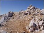
 | Belopeška jezera - Mangart (Via Italiana)
Mangart (also spelled Mangrt; both forms are grammatically correct) is a mountain that attracts a large number of visitors in summer. Access to t...
5 h 30 min |
 | Koschutahaus - Koschutnikturm (Košutnikov turn) (via Cjajnik / Lärchenturm)
Košutnikov Turn is the highest peak in Košuta, the longest Slovenian ridge. The summit offers a beautiful view of the entire ridge. Austria and t...
4 h 30 min |
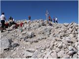
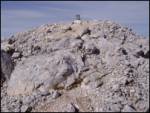
 | Rifugio Tolazzi - Monte Coglians (Hohe Warte) (Weg der 26er)
Monte Coglians (Hohe Warte) is, at 2,780 meters, the highest mountain of the Carnic Alps. From the summit, which has a cross and a bell, there is...
5 h 30 min |
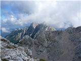
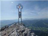
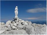 | Zajzera - Viš/Jof Fuart (Gola Nordest)
Viš is a 2,666 m high peak in the western Julian Alps. From the summit, which features a statue of St. Mary and a cross beside it, there are fine...
6 h |
 | Belopeška jezera - Vevnica (Via della Vita)
Vevnica is a wonderfully wild and lonely mountain that concludes the ridge stretching from Ponce towards Vevniško sedlo. All approaches to it are...
6 h |
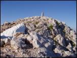
 | Erschbaum - Große Kinigat / Monte Cavallino (Klettersteig)
Große Kinigat / Monte Cavallino is a 2,689-meter peak in the Carnic Alps. Located in the western part, it is one of the few there made of limesto...
4 h 30 min |
| Sele pri Cerkvi / Zell - Pfarre - Koschutnikturm (Košutnikov turn) (via Cjajnik)
Košutnikov Turn is the highest peak in Košuta, the longest Slovenian ridge. The summit offers a beautiful view of the entire ridge. Austria and t...
5 h 45 min |
| Ridovc / Ridovcsäge - Koschutnikturm (Košutnikov turn) (by Mrzli potok and over Cjajnik)
Košutnikov Turn is the highest peak in Košuta, the longest Slovenian ridge. The summit offers a beautiful view of the entire ridge. Austria and t...
5 h 55 min |
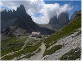 | Landro - Torre di Toblin / Toblinger Knoten
Torre di Toblin is a 2,617-meter peak in the Sexten Dolomites Nature Park. This challenging summit is accessed via an interesting via ferrata, of...
4 h 30 min |
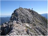
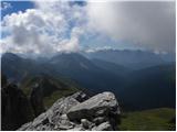
 | Ravenska Kočna - Grintovec (on ferrata and Frischaufova pot)
Grintovec is the highest peak of the Kamnik-Savinja Alps. It is located above the Kamniška Bistrica Valley, Suhi Dol, and the Ravenska Kočna Vall...
5 h 45 min |
 | Ravenska Kočna - Grintovec (on ferrata and Kremžarjeva pot)
Grintovec is the highest peak of the Kamnik-Savinja Alps. It is located above the Kamniška Bistrica Valley, Suhi Dol, and the Ravenska Kočna Vall...
5 h 45 min |
 | Ravenska Kočna - Jezerska Kočna (on ferrata and Kremžarjeva pot)
Jezerska Kočna is located west of Grintovec. From the summit, there is a very nice view towards Grintovec. The Karawanks and the Gorenjska plain ...
5 h 30 min |
 | Ravenska Kočna - Skuta (on ferrata and over Dolgi hrbet)
Skuta is a 2,532-meter-high mountain located in the heart of the Kamnik-Savinja Alps. From the summit, which has a logbook box and a stamp, a bea...
6 h 15 min |
 | Ravenska Kočna - Kokrska Kočna (on ferrata and Kremžarjeva pot)
Kokrska Kočna is a panoramic and spacious mountain between Jezersko and Suhadolnik. From the summit, which has a logbook box, there is a very nic...
6 h |
 | Ravenska Kočna - Dolgi hrbet (on ferrata and on path Frischaufova pot)
Dolgi Hrbet lies between Grintovec and Skuta. From its precipitous summit there is a fine view across the heart of the Kamnik-Savinja Alps. Dolgi...
5 h 30 min |
 | Ullachtal - Westliche Mitterspitze (Leoganger Süd Klettersteig)
Westliche Mitterspitze is a 2,160-metre mountain in the Leoganger Steinberge group. The mountain is known primarily for the extremely demanding L...
5 h |
 | Ullachtal - Westliche Mitterspitze (Leoganger Nord Klettersteig)
Westliche Mitterspitze is a 2,160-metre mountain in the Leoganger Steinberge group. The mountain is known primarily for the extremely demanding L...
5 h |