General riddle without stopping!
|
| CarpeDiem2477. 02. 2012 19:07:14 |
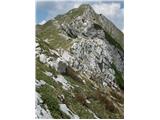
Main peak, 2142m, don't know if it has any other name besides Krnčica? 
|
|
|
|
| turbo7. 02. 2012 19:09:12 |
or Skutnik or Lopatnik 
|
|
|
|
| tisa7. 02. 2012 19:22:08 |
Oblo brdo?
|
|
|
|
| atoamac7. 02. 2012 19:24:37 |
Not Oblo brdo, but the direction is right.
|
|
|
|
| tisa7. 02. 2012 19:29:01 |
Vršič maybe?
|
|
|
|
| atoamac7. 02. 2012 19:31:57 |
Vršič it is, but which of the two?
|
|
|
|
| tisa7. 02. 2012 19:38:22 |
That other peak is Vršiči, at least that's how it's marked on my map.
|
|
|
|
| atoamac7. 02. 2012 19:51:46 |
Maybe, on mine (Geopedija) both are named equally, namely Vršič (1699m) and Vršič (1897 m). That lower Vršič is named Kal on the older map Krnsko pogorje and Kobarid 1:25000 (PZS) from 1990 and one meter lower. Julijske Alpe western part 1:50000 PZS from 1973 marks only the higher one. Triglav National Park 1:50000 PZS from 2000 attributes 1700 m above sea level to Kal.
|
|
|
|
| IgorZlodej7. 02. 2012 19:55:10 |
Nice ridge. Entire traverse Čezsoča - Slatenik - Kal - Vršiči - Oblo Brdo - Lopatnik - Krnčica to Krn done twice. Once we picked up two dead glider pilots from the wreckage of a glider plane at Vratih, once rescued a Czech with a broken leg under Skutnik, and a paraglider under Krnčica, a dead Italian under Vršiči, all cases with helicopter.
|
|
|
|
| tisa7. 02. 2012 20:00:38 |
And which one is on your picture?
|
|
|
|
| atoamac7. 02. 2012 20:08:40 |
In the picture it's the higher one, so Vršič. Tour description and surroundings pictures, also the peaks mentioned in the riddle you find in the List of Mountains on the left. I warmly recommend ridge crossing, but carefully so you get down on foot.
|
|
|
|
| tisa7. 02. 2012 20:13:02 |
Thanks atoamac, I really like ridge paths, maybe I'll really go on this path, already because I don't know this end except Krn and the lake.
Nice regards.
|
|
|
|
| miri7. 02. 2012 20:32:16 |
D....n, I have it on my album but didn't recognize it.
 1 1
|
|
|
|
| IgorZlodej7. 02. 2012 21:51:02 |
Tisa, from Slatenik up over Lukeževo brdo to Kal there is no path, it's pathless, but easier access possible from Zaprikraj pasture, path not marked.
|
|
|
|
| tisa7. 02. 2012 22:20:22 |
Thanks Igor for the data and warnings. Nice regards and good luck.
|
|
|
|
| tisa8. 02. 2012 18:42:01 |
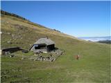
Which mountain is in the picture?
 1 1
|
|
|
|
| tisa8. 02. 2012 19:09:52 |
It's correct, julius.
|
|
|
|
| julius8. 02. 2012 19:46:59 |
Where did I take this picture?
 1 1
|
|
|
You must log in to post a comment:
If you do not yet have a username, you must first
register.