General riddle without stopping!
|
| B28. 02. 2012 20:06:13 |
 1 1
|
|
|
|
| B28. 02. 2012 20:53:50 |
On which secured trail did I walk?
 1 1
|
|
|
|
| B29. 02. 2012 09:38:28 |
ajda, almost 200 south and julius almost 50 km southeast!
|
|
|
|
| miri9. 02. 2012 11:23:59 |
 1 1
|
|
|
|
| CarpeDiem2479. 02. 2012 13:03:01 |
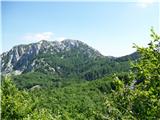
Then it could be Snežnik, if I interpret the sky side hints well! 
But it's also possible it's already across our southern border? 
|
|
|
|
| B29. 02. 2012 13:25:16 |
No, no. It's in southern Primorska... Let me help, in the right corner you can see water...
| (+1) |  | |
|
|
|
|
| otiv9. 02. 2012 15:53:12 |
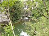
Or is it the gorge of the Glinščica river?
| (+1) | | |
|
|
|
|
| B29. 02. 2012 17:47:38 |
it is in Slovenia and northeast of Glinščica
|
|
|
|
| miri9. 02. 2012 18:53:14 |
Something doesn't add up. 50 km SE of Gradiška Tura, and NE of Glinščica?
|
|
|
|
| atoamac9. 02. 2012 20:06:28 |
or maybe access to some cave?
|
|
|
|
| B29. 02. 2012 21:25:51 |
Yes, water always flows to the sea... Or to a cave - and then to the sea... And nice paths lead along it... Because the nut is too hard, I help...
 1 1
|
|
|
|
| miri9. 02. 2012 21:51:36 |
@šodrovc, that didn't go into my head.
| (+1) | | |
|
|
|
|
| B29. 02. 2012 22:05:43 |
Hello!
I really don't know what this is about anymore? Maybe about recalculating kilometer distances or not knowing our beautiful Slovenia? Obviously you really couldn't figure out that the photos were taken in the gorge of the Reka river... Never mind! This section is not for "experts" of various "geographers"... but probably for ordinary hikers and walkers who like beautiful nature... And set out on the nicely marked circular path from Motoun (Škocjan Caves park to Vremščica 3.30 hours to the chapel of St. Urban and descend towards Škocjan Caves (along the gorge of the Reka river) back to the start... And all "nautical" and navigational "smartnesses" are over! The whole loop takes around 10 hours and you'll have a nice and educational outing!
| (+1) | | |
|
|
|
|
| miri9. 02. 2012 22:12:42 |
And to ordinary hikers like me, you shouldn't provide such wrong data. Otherwise thanks for the trip idea. And no hard feelings, of course.
|
|
|
|
| B29. 02. 2012 22:12:48 |
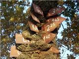
I won't wait for a reply, let's move on! Where are these directional signs located?
 1 1
|
|
|
|
| B29. 02. 2012 22:33:31 |
Sorry, miri, and I didn't give any wrong data! It's about knowing the terrain and obviously the beautiful Reka river gorge is a big problem for most... Take your time and visit it... Map calculations though, let that be your second plan... And no hard feelings and my instructions were approximately accurate... Also "signposts" are somewhere on the coast... WHERE???
|
|
|
You must log in to post a comment:
If you do not yet have a username, you must first
register.