General riddle without stopping!
|
| otiv26. 11. 2010 09:44:45 |
Maybe I'm wrong too. I've been to those areas rarely.
|
|
|
|
| tisa26. 11. 2010 09:52:59 |
Because the peak should have an adjective and noun in its name, I ran out of ideas and have a long nose. 
|
|
|
|
| otiv26. 11. 2010 10:02:16 |
@tisa!
adjective and noun referred to the snowy mountain in the picture.
|
|
|
|
| tisa26. 11. 2010 10:13:54 |
Ups, obviously I didn't follow the development of messages well. 
God knows where this peak is. All crags and little crags, high and low, only such "chamois" like atoamac, šodrovc, Igor etc. know. We, "ordinary mortals" really can't measure up to them.
|
|
|
|
| otiv26. 11. 2010 10:18:02 |
Now I'm going south too. Is it near Jerebica?
|
|
|
|
| otiv26. 11. 2010 10:29:20 |
Here one sees if one can spot the picture on the map too. That's why I'm more convinced it's north of Predel.
|
|
|
|
| atoamac26. 11. 2010 10:37:52 |
Hint: we've established it's north of Predel, west of Vevnica and Visoka Ponca, north of Bukovnik. If a really tall larch grew on top, it might reach the magic 2K limit.
|
|
|
|
| tisa26. 11. 2010 11:02:42 |
|
|
|
|
| otiv26. 11. 2010 11:03:38 |
Maybe Tore di Valromana.
|
|
|
|
| miri26. 11. 2010 11:22:06 |
|
|
|
|
| atoamac26. 11. 2010 11:23:03 |
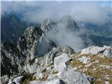
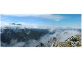
That's right. In the picture is Torre di ValRomana or Remšendolski stolp, 1972m, taken from the multi-named peak (Kopa, Poldnik, Picco di Mezzodi, Weissenfelser Mittagkogel and probably some Friulian name), on šodrovc's and my picture it's in the middle, to the right is also Breitkofel, 1988m, for which I haven't come across translated names, but with a dictionary it could mean Široka glavica. Apparently there were very few hikers on both, if any. Montebello/Schoneck/Lepa glava is behind and not visible.
Otiv, the word is yours.
 1 1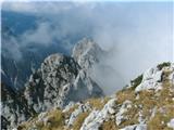 2 2
|
|
|
|
| tisa26. 11. 2010 11:29:02 |
Congratulations for such a tough nut, otiv
|
|
|
|
| otiv26. 11. 2010 12:33:36 |
Thanks! Sorry for the delay, I was out in the field.
Let @tisa propose the riddle. I have no material or digital gear.
|
|
|
|
| šodrovc26. 11. 2010 12:44:22 |
@atoamac - slowly, slowly. You've confidently concluded this; don't you have any doubts, say if you look at the map?
|
|
|
|
| otiv26. 11. 2010 12:50:28 |
That's interesting! Just so lunch doesn't stick to me.
|
|
|
|
| otiv26. 11. 2010 13:01:04 |
Maybe it should really be closer to the Stone Hunter??
|
|
|
|
| atoamac26. 11. 2010 13:01:50 |
@šodrovc - I'm looking at the map and I have no doubts at all that you're preparing some kind of surprise
|
|
|
|
| otiv26. 11. 2010 13:06:22 |
Namely, on the picture you can recognize two valleys to K.L. from T.di.V. to K.L. there are three though?
|
|
|
|
| šodrovc26. 11. 2010 13:21:03 |
@atoamac,
you know, I'm just a bit curious and wonder if the positions of Breitkofel and R. tower on the map seem consistent to you with the photo showing them?
I'm also interested in one of your hints where you say:
"No, but you're close. On šodrovc's wider picture Mali Sciober covers the Rabelj peaks..."
- namely on my photo there's no Mali Sciober - if I had photographed a bit more to the left it would be, but in that case, the Rabelj peaks wouldn't be covered, but would be clearly visible.
|
|
|
|
| atoamac26. 11. 2010 13:47:34 |
TNP map 1:50000 is actually not precise enough for judgment. If the elevations are accurate, the elevation mark for TdV should be somewhere above both peaks.
I've attached two more pictures - sorry, it takes a bit - so @šodrovc you're right about the Rabelj peaks, they are directly visible on the panoramic picture - below Montaž.
The second picture is a bit beyond the border between Rateče and Trbiž: Kopa/Poldnik on the left and Breitkofel on the right, in between - per map - Remšendolski stolp, right of Breitkofel Schoneck. Also on Gorazd's picture of Kopa from his posts you can clearly see the sequence of these peaks, which are not a single mass, but several towers.
 1 1 2 2
|
|
|
You must log in to post a comment:
If you do not yet have a username, you must first
register.