General riddle without stopping!
|
| otiv26. 11. 2010 13:49:48 |
That's a real riddle. In my opinion these aren't the same mountains in the photos.
|
|
|
|
| šodrovc26. 11. 2010 14:07:45 |
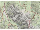
@otiv, completely bottom right in the corner are the same mountains, while now we can clearly see the Rabelj Peaks too (which thus aren't covered by Mali Schiober).
to make it all a bit more complicated, I'm attaching our map and a map detail (Alpi Giulie Tarvisio (Tabacco 019)), where 6 peaks are named and with them 9 contour points in the ridge from Kopa towards NW:
Schoneck (Montebello) left 1787m, below 1844m
Gesperrterkofel 1883m
Ranftkofel 1891m
Breitkofel left 1831m, below 1988m
Torre di Val Romana 1972m
Schonkofl right 1917m, above 1871
 1 1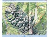 2 2
|
|
|
|
| atoamac26. 11. 2010 14:30:49 |
On Austrian map online only Schoneck 1844 and Kopa are named, but by the 1900 contour you can see there's something higher in between (Breitkofel).
Anyway, we'll have to go check it on site in summer. But the trip to Kopa, from where I took the photo, is recommended for the wonderful views in all directions.
And also: @šodrovc, hats off, how you recognized the detail despite the fog.
|
|
|
|
| otiv26. 11. 2010 14:36:20 |
Although I usually trust the photographer. Right now I don't know what to say about all these complications. Almost too much for my graying head.
|
|
|
|
| atoamac26. 11. 2010 15:16:50 |
If the picture says more than the map, here... from the path to Mangart
 1 1
|
|
|
|
| šodrovc26. 11. 2010 15:29:36 |
Besides a bunch of names and elevation points, there are also different heights in different sources. Like this for Breitkofel:
Julijske alpe (western part) - 1988m
Julijske Alpe hiking guide (Tine Mihelič) - 1955m
Alpi Giulie Tarvisio (Tabacco 019) - two points: 1831m, 1988m
Alpi Giulie (Gino Buscaini) - 1990m
Good luck figuring it out if you can   . .
And another interesting thing about naming the peaks in the ridge from Kopa towards NW, where we don't find Slovenian names, but nevertheless there is one completely forgotten one, as Tine Mihelič mentions, that's Šenuk (yes, with u, German Schöneck, Italian Montebello).
I admit, I don't dare name exactly what (all) is on atoamac's photo. I'm skeptical about the R. Stolp solution, based on the maps (but what when they are so often inaccurate), I tend most towards the 1831m point (near Breitkofel), which is visible on the Italian map. We'll really have to go there to check, but stepping onto one of the peaks seems like quite a tough undertaking for šodrovski range. That area is considered one of the most inaccessible and loneliest parts in the entire Julians. We can wait for tireless explorers ala Stritar (Terra incognita juliana (sniffing around Breitkofel & co.)), to finish their work, or hope that some dr. with his better half will take it as a challenge  ... ...
hey atoamac, this from Mang(a)rt is interesting, and it increases my leaning towards the above mentioned solution a bit...
|
|
|
|
| Gorazd G26. 11. 2010 15:38:48 |
In naming and heights of the mentioned peaks it's clear that nothing is clear.
As you've already figured out, the sources we can use aren't uniform. That's why under the photo in the post about Kopa/Poldnik, which atoamac mentions, I didn't write the names of these peaks. I don't dare, because I really don't know how it's (most) correct, even though I've checked quite some literature.
|
|
|
|
| Gorazd G26. 11. 2010 15:42:48 |
šodrovc, we wrote at the same time. 
Hm, yeah, ... If you're waiting for me, probably a few more years will pass. 
I think the real dr. with his two companions will finish the work sooner.
|
|
|
|
| otiv26. 11. 2010 16:49:25 |
What, are you all clearing snow already. Post a new riddle.
|
|
|
|
| tisa26. 11. 2010 18:10:27 |
Let there be a little break otiv, so you don't burn dinner too
|
|
|
|
| capraibex26. 11. 2010 18:47:34 |
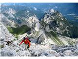
Again an easy riddle, that's why I'm asking for the mountain name and from where it's photographed.
 1 1
|
|
|
|
| hanč26. 11. 2010 18:53:03 |
Stol,but don't know from where
|
|
|
|
| benjamin726. 11. 2010 19:05:29 |
From the east, Zelenica area.
|
|
|
|
| otiv26. 11. 2010 19:06:38 |
Maybe it's photographed somewhere between Dobrča and Begunjščica.
|
|
|
|
| capraibex26. 11. 2010 19:07:09 |
Stol photographed from Dobrča
|
|
|
|
| tisa26. 11. 2010 19:20:56 |
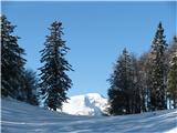
Another easy one. Where is the alpine pasture and what's its name.
 1 1
|
|
|
|
| gmajna26. 11. 2010 19:34:05 |
planina Jasenje, below Rutarski Vršič
|
|
|
|
| tisa26. 11. 2010 19:35:23 |
No, not that alpine pasture.
|
|
|
|
| otiv26. 11. 2010 19:37:19 |
Tod, but I don't know if I've been there. It's in Julijcih.
|
|
|
|
| otiv26. 11. 2010 19:47:41 |
And where does the cart track lead?
|
|
|
You must log in to post a comment:
If you do not yet have a username, you must first
register.