|
| joža x1. 02. 2011 18:04:11 |
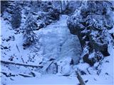
Today, an escape from the lowlands was necessary after a few gloomy days. So I started at 8.00 along the Lobnica valley to Šumik, then on to Bajgot and towards Klopni vrh. Sunshine greeted me at Bajgot. At the starting point, a sample of snow at Šumik 10 cm towards K.Vrh 20 cm, and quite some ice on the path. Part of the path from Šumik to Bajgot requires a lot of caution. I didn't use crampons over the icy parts of the path; I helped myself with the ice axe.
 1 1
|
|
|
|
| joža x14. 02. 2011 19:25:28 |
Weather today wasn't encouraging, but when the path calls. Along Lobnica valley to Šumik and on to Bajgot (rest area, parking above Šumik). Start at 13.40, finish 17.40 (half dark). On the path snow only a sample, on Bajgot a bit more, less ice than last time. Yesterday just enough snow fell to cover roots, ice and ledges on the path, so caution needed.
|
|
|
|
| joža x22. 04. 2011 21:49:44 |
This afternoon for conditioning: Lobnica-Šumik-Bajgot-Areh and back the same way. Path dry, today very solitary, only birdsong and wind.
|
|
|
|
| Mbčan15. 05. 2011 08:48:33 |
How long did it take you from Lobnica to Areh?
|
|
|
|
| joža x18. 05. 2011 21:45:47 |
Sorry for the delay, all trips from Lobnica I do in the afternoon, to Areh and back 5.5 hours.
|
|
|
|
| Mbčan18. 05. 2011 22:03:30 |
By map I see it's about 3km straight line, or around 5 km path one way, Lobnica at 700m, Areh 1250m....
For 10 km and 500 m elevation gain it's 5.5 hours quite a lot?
Did you have lunch included?
|
|
|
|
| Mbčan18. 05. 2011 22:05:34 |
oh, I forgot, you mean 5.5 hours from Lobnica to Šumik and back?
|
|
|
|
| joža x20. 05. 2011 05:35:48 |
Don't look at the map, don't calculate, just go into nature and don't look too much at the clock, life is short. If you make it from Lobnica (from asphalt) to Areh and back in 5.5 hours like me on marked path you'll have to step diligently.
|
|
|
|
| Mbčan20. 05. 2011 09:36:43 |
I'll go on Sunday, most likely decided to walk this path but still Lobnica (alt.680) and to Areh -(sport hotel Areh) on marked path 5.5 hours seems quite a lot to me!
Regards!
|
|
|
|
| joža x20. 05. 2011 17:29:22 |
THIRD TIME (LAST): FROM LOBNICA (FROM ASPHALT) TO AREH, ON MARKED PATH AND BACK!!! I TOOK 5.5 HOURS. READ WELL WHAT I WRITE AND THEN COMMENT AND SET RECORDS AS MUCH AS YOU WANT. ACCORDING TO GUIDES THIS TOUR IS 7 HOURS LONG.
|
|
|
|
| FLEKSARCA20. 05. 2011 18:41:54 |
Here, damn, can I catch Joža?
|
|
|
|
| turbo20. 05. 2011 19:03:46 |
FLEKSARCA,
in my opinion joža_x went by bike 
|
|
|
|
| bruny20. 05. 2011 19:37:31 |
Mbčan & joža x
Get one of these GARMIN watches  and to the start in Lobnica, then to Areh and back to Lobnica and we'll know how much!? and what!? in kilometers and hours... Treat yourselves to lunch and a beer... and to the start in Lobnica, then to Areh and back to Lobnica and we'll know how much!? and what!? in kilometers and hours... Treat yourselves to lunch and a beer...
|
|
|
|
| mosovnik20. 05. 2011 20:28:23 |
Since this area is almost my "backyard", I have to chime in, because I've done this path countless times in all directions, marked and also "across", so you don't argue and namely:
- if the tour is set from Lobnica on marked path to Šumik waterfall and on to Bajgot and then via Tinčeva bajta and Peršetov vrh over Žigartov vrh to Areh and back on same track, no way with fast walking you can arrive in the mentioned time. But possible if you're a mountain runner.
I won't intentionally state "acceptable" walking time on this route because it's relative. It seems silly to me that you argue about timing here on the forum. You believe the statement or not. Approximate times are stated in guides and path described, if someone is interested in details, anyway via ZS can ask someone. So arguing, boasting and god forbid insulting on this forum really not necessary.  
|
|
|
|
| Mbčan20. 05. 2011 20:59:21 |
No one is arguing, and I don't want arguments on forum, everyone walks as suits them.
Personally I haven't walked the path from Lobnica to sport hotel Areh yet, without extensions to Šumik, Bajgot,.... so I take the blame.
Sorry if I offended anyone, wasn't my intention!
|
|
|
|
| joža x20. 05. 2011 22:22:23 |
Mosovnik, I too have walked the paths in this part of Pohorje countless times in all directions. What can be walked or run in what time depends on the individual's ability, so don't judge what can be done and what not. Bruny, we who have kept contact with nature don't need navigation, as we have navigation given by nature itself. Garmins are maybe for some.... The time written in the post in big letters is achievable for every well-trodden mountaineer.
|
|
|
|
| Mbčan21. 05. 2011 08:56:34 |
Joža, the little problem arose because of the info I still don't have. The walking time only from Lobnica to Areh interests me, so direct path, without various Šumiks,.... so direct path from Lobnica to Šumik. Half an hour I assume is more than enough one way 
|
|
|
|
| bruny21. 05. 2011 09:23:44 |
joža x it's nice that you've kept contact with nature and we others keep it more or less too. I didn't write that you need navigation for orientation but really whoever operates with times when something started and ended must also... provide something. Who on the forum cares that you started some path at 13:40 and finished at 17:40 - more important is that you've ,,revealed,, a piece of beauty on Pohorje - a part that maybe you know best, time will be anyway, whoever has competitive intentions will
set it himself according to his abilities...
I move freely on paths or along markings - I don't preload paths because that would really lose the charm of hiking. But true I use navigation - or better said personal trainer for recording activity and analysis of the done path and if useful to someone - why not!
|
|
|
|
| joža x21. 05. 2011 20:36:37 |
The time needed for a tour interests me a lot, if I'm heading to another part of Slovenia, especially if the mountaineer adds his own pace. With times on P.T. signposts and guidebooks I have such experiences that sometimes I halve them without problem sometimes barely reach them, so info from a hiker who walked the path can be important. So it's not about boasting, but simple data on tour duration. I don't have anything to boast about with my times anyway.
|
|
|
|
| cemprin29. 05. 2011 12:15:42 |
Mbčan you'll have to decide what you mean with your question. As far as I understand, the intended path is along Lobnica stream to Šumik waterfall, Bajgota and from there to Areh.
Marked paths along Lobnica don't lead anywhere else but past both waterfalls....If you want to know how long a path on unmarked trail past e.g. Uršanka, Ozima and Pisker ski slope to Areh would take then it's approximately as far as from Ruše to Areh, and last year at the mountain run to Areh the best time of runners was!! 00:42:10!!!.
You'll have to think what interests you,(which path) then maybe you'll get an answer.
|
|
|
You must log in to post a comment:
If you do not yet have a username, you must first
register.