Way of St. James – Gorenjska Branch
|
| sirt16. 04. 2014 10:18:20 |
Bagi, don't mind if I correct you a bit. In Radolca you descend to Sava, which you cross in Lancovo, and past the confluence of both Savas the path runs along Sava Bohinjka (pic. 18) towards Bodešče. To Radovna you'll arrive in Krnica.
No hard feelings.
| (+1) |  | |
|
|
|
|
| bagi6. 04. 2014 15:35:31 |
Of course I won't mind, you're absolutely right  . I was already thinking a bit about the next day when Radovna keeps company for long. Thanks for the correction . I was already thinking a bit about the next day when Radovna keeps company for long. Thanks for the correction  . .
| (+2) | | |
|
|
|
|
| bagi20. 04. 2014 21:57:51 |
Day 3 - path from Bled to Kranjska Gora
Another nice morning dawns . Last greeting to hosts, backpack on shoulder and path under feet. My god, did I already say how heavy my companion is??? Over 10 kg with everything you need for a week or a month of walking, no difference. Quite hefty when I look at it filled to the top .
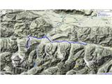
Well, let's go on. Past the junction to Bled Castle, continue along the main road in the direction of Gorje until the next left junction invites you towards Bled train station. Walk another good kilometer, then go right through the underpass. Here the signs for Jakob start, which won't leave you until Italy. Soon you switch to a forest path that takes you along the hillsides of meadows towards Zg. Gorje, past the church to the best neighbor's shop. After it, you descend towards the castle mills and Grabče, go over the bridge and marvel at how nice it is there  . Along the right bank the path leads towards Krnica and further along the Radovna valley. The direction is clear. To Psnak for refreshment and then knee-killer on asphalt over Kosmačev pass towards Mojstrana . Along the right bank the path leads towards Krnica and further along the Radovna valley. The direction is clear. To Psnak for refreshment and then knee-killer on asphalt over Kosmačev pass towards Mojstrana  . .
In Mojstrana, just be a bit careful. One tiny yellow arrow on the sidewalk near the shop will show you the right direction. Along the left bank of Sava you go past the park and then mostly on unknown paths towards Martuljek. Midway you join the bike path and in Martuljek before the bridge be careful again. Here the path leaves the bike path and crosses the road to the right bank of Sava. Past hotel Špik continue on the wide track and later on the forest trail all the way to Kranjska Gora.
Here I slept in hostel Nika, which is right on the path. The small room became mine for one night and the shower took care that I properly relaxed . To make the joy even greater, they directed me for breakfast to the neighboring hotel and there I had loads of food available. Good for the stomach, bad for the first morning steps .
Today's part of the path will be tailored to all who prefer to walk a bit more level . It adds up to 38 km and count on somewhere from 8 to 10 hours
 1 1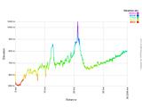 2 2 3 3 4 4 5 5 6 6 7 7 8 8 9 9 10 10 11 11 12 12 13 13 14 14 15 15 16 16 17 17 18 18 19 19 20 20 21 21 22 22
| (+6) | | |
|
|
|
|
| bagi21. 04. 2014 11:21:19 |
Day 4 - path from Kranjska Gora to Višarje
It came, the last day came . You can hardly believe everything you've already walked, right?? Not much left to the goal, nice today's path, just a little ascent still to Višarje. There around 1000 elevation meters for a nice conclusion .
Straight across the road to the central square of Kranjska Gora and there join the bike path at the foot of the ski slopes. You'll have a wide path all the way to Žabnica above Trbiž, so don't search too much for signs for Jakob's path. There won't be any more and you don't need them. On the bike path you cross the border and at the junction for Belopeška lakes turn it right towards Trbiž. Nice is this route of the former railway line along which you walk . Also in Trbiž you'll be surprised how elegantly you'll avoid all roads and enjoy the view far around. You'll go to Žabnica and in the middle of the village turn left towards the gondola. Now just prepare for the concluding ascent, worthy of the walked path  . .
Don't look at the ski slope, you won't go there. To Višarje you'll ascend on the old pilgrimage path. Past the gondola station head as if you were returning towards Trbiž. You now have the motorway on the left side, on the right a large meadow with parking lots along its edge. At the end of the meadow there's a cluster of houses, towards which a narrow asphalt road turns right. There you'll spot the sign and the first marks for Mt. Lussari are not far either. You're on the right path, soon you'll walk on gravel, groaning here and there at the steepness and steadily approaching the goal. A bit below the pasture you'll see the new part of the path on the right. Go there. The old one had to give way to progress in the form of the ski slope. A little more, less than half an hour and you're at the top. The goal is reached, you've won. Congratulations to you and to each one who has walked this path from Ljubljana to Višarje. You can be proud of yourself .
Today's concluding paths will delight all those who somehow always manage to get lost . That's almost impossible here. Under 30 km the counter will show at the end and 8 to 10 hours of walking from Kranjska Gora.
One small warning... check the gondola timetable for the return. I was there at the end of September and during the week it wasn't operating. Then Višarje is just a ghost village. Everything is closed, no refreshment and you even have to walk back to the valley . And don't let the return via the ski slope tempt you .
 1 1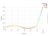 2 2 3 3 4 4 5 5 6 6 7 7 8 8 9 9 10 10 11 11 12 12") 13 13 14 14 15 15 16 16 17 17 18 18
| (+7) | | |
|
|
|
|
| barand10. 05. 2016 09:50:06 |
Mr. Emil (Bagi) to your email gasperin.emil@gmail.com I sent some questions. If you find time to reply I'll be very happy. Thank you and best regards.
|
|
|
|
| bagi10. 05. 2016 10:07:24 |
@barand ... answers surely coming soon. Only a few days since end of my this year's Spanish Camino and not fully up to speed with all matters yet
| (+3) | | |
|
|
|
|
| barand10. 05. 2016 13:24:05 |
Big thanks and congrats for the completed path.
| (+1) | | |
|
|
|
|
| darinka410. 05. 2016 17:46:30 |
Congratulations also from my side. I hope the shoes are still intact.
| (+1) | | |
|
|
|
|
| Majdag15. 02. 2017 15:11:12 |
Following the yellow scallop signs..
.. Yesterday my Ira and I went to walk part of this Jakob's Path. We start in Mojstrana and end at the main road just before Martuljek. Nice forest paths, currently a bit icy, leading to the cycle path. In both directions quite some km add up. On the whole path silence, peace and sun. Only the birds haven't started chirping yet.
http://jelenkamenmajdag.blogspot.si/2017/02/ob-savi-dolinki-po-oznakah-rumenih.html
| (+3) | | |
|
|
|
|
| Majdag4. 03. 2017 16:58:16 |
| (+3) | | |
|
|
|
|
| marsus7. 03. 2017 09:55:29 |
Majdag, your blog from Martuljek to Kranjska Gora doesn't open...
| (+1) | | |
|
|
|
|
| geppo7. 03. 2017 10:02:44 |
Look on the right side of the blog - archive
click on: from Martuljek to Kranjska G. and it will open
regards
| (+2) | | |
|
|
|
|
| Majdag7. 03. 2017 10:13:56 |
 1 1
| (+2) | | |
|
|
|
|
| Majdag16. 03. 2017 12:51:10 |
| (+5) | | |
|
|
|
|
| sirt116. 03. 2017 15:56:55 |
In the comment before picture 61 a mistake crept in. Village Podkoren.
| (+1) | | |
|
|
|
|
| Majdag16. 03. 2017 17:13:15 |
...Thanks sirt1, I fixed it.
|
|
|
|
| Petra53. 04. 2017 11:37:49 |
On Saturday after five days of walking I also completed the Upper Carniola Jakob's Path myself. It was unforgettable, especially because I witnessed the sunrise at Višarje on my birthday.
The path takes at least five days, six would be even better... It's long especially from Bled to Kr. Gora and from Kr. Gora to Višarje. I would shorten the last stage a bit myself, to have less flat and easier step into the climb. Otherwise, despite occasionally unclear markings, a wonderful path and feelings that can't be described... So - go on the Path.
| (+3) | | |
|
|
|
|
| Majdag3. 04. 2017 16:58:35 |
| (+3) | | |
|
|
|
|
| Majdag13. 04. 2017 14:50:34 |
| (+5) | | |
|
|
|
|
| Majdag30. 04. 2017 15:40:54 |
| (+1) | | |
|
|
|
You must log in to post a comment:
If you do not yet have a username, you must first
register.