Plöckenhaus - Polinik (path 403)
Starting point: Plöckenhaus (1215 m)
| Latitude/Longitude: | 46,61628°N 12,95179°E |
| |
Route name: path 403
Walking time: 3 h 15 min
Difficulty: easy marked way
Elevation gain: 1117 m
Elevation difference along the route: 1130 m
Map: Tabacco 09 (Alpi Carniche, Carnia Centrale 1:25000)
Recommended equipment (summer):
Recommended equipment (winter):
Views: 3.000
 | 1 person like this post |
Access to starting point:
From Slovenia, the starting point at the Plöckenhaus guesthouse is reached most quickly through the Karavanke Tunnel, where at Beljak you turn towards Hermagor and continue on the regional road to Kötschach, just before which you turn left towards the Plöckenpass / Passo di Monte Croce pass. Follow the road to the parking lot at the Plöckenhaus hut.
Alternative access is from the Italian side. From Trbiž/Tarvisio on the highway towards Vidm/Udine. At Carnico, take the exit from the highway and first follow the signs towards Tolmezzo, then the signs for Austria and the Pso di Croce Carnico / Plöckenpass pass. Drive over the pass to the Austrian side to the parking lot at the Plöckenhaus hut.
Route description:
The trail starts at the parking lot opposite the Plöckenhaus guesthouse. From the parking lot to the Green Lake a gravel road leads, which partially turns into a cart track. The trail is marked with number 403. To the lake it is 10 minutes of walking (15 minutes to the eastern shore).
After the lake a trail branches off to the left, which turns into the steep slopes towards the alpine pasture Untere Spielboden. On the steep uphill path through the trees views of the valley open rarely.
The trail then climbs to a gravel road or better cart track, which is followed to the right. The cart track is followed eastwards, then the trail branches off again to the left into the forest. Follow the trail to the alpine pasture Untere Spielbodenalm, on which a hut stands.
Behind the hut the trail climbs through the forest and reaches a narrow forest road, along which one continues straight east. After a few turns on the road a wider footpath branches off to the left. Continue on the footpath and soon reach the forest boundary.
Behind the forest boundary begin the pastures of the larger alpine pasture Obere Spielbodenalm. To the hut on the alpine pasture it is still a few minutes of walking.
Behind the alpine pasture the trail ascends northwest until it reaches a huge natural grass-covered amphitheater between the mountains Polinik, 2332 m and Elferspitz, 2254 m. Here the trail sticks to the slopes of Polinik, whose slopes are crossed northeast to the saddle Spielbodentörl at 2095 meters. East of the saddle Elferspitz rises in impassable terrain, west the trail leads to Polinik.
The trail first ascends through grassy terrain, soon rocky terrain replaces it. The steepest terrain is in the last part of the trail before the summit (and also somewhat crumbly). The trail then leads to the summit. On the summit there is a bell, below the summit a few dozen meters lower on the northern side a larger concrete cross is placed. By the cross there is also the summit book.
The summit among others offers excellent views over the Zilja Valley and the eastern part of the Carnic Alps.

Photos:
 1
1 2
2 3
3 4
4 5
5 6
6 7
7 8
8 9
9 10
10 11
11 12
12 13
13 14
14 15
15 16
16 17
17 18
18 19
19 20
20 21
21 22
22 23
23 24
24 25
25 26
26 27
27 28
28 29
29 30
30 31
31 32
32 33
33 34
34 35
35 36
36 37
37 38
38 39
39 40
40 41
41 42
42 43
43 44
44 45
45 46
46 47
47 48
48 49
49 50
50 51
51 52
52 53
53 54
54 55
55 56
56 57
57 58
58 59
59 60
60 61
61 62
62 63
63 64
64 65
65 66
66 67
67 68
68 69
69 70
70 71
71 72
72 73
73 74
74 75
75 76
76 77
77 78
78 79
79 80
80 81
81 82
82 83
83 84
84 85
85 86
86 87
87 88
88 89
89 90
90 91
91 92
92 93
93 94
94 95
95 96
96 97
97 98
98 99
99 100
100 101
101 102
102 103
103 104
104 105
105 106
106 107
107 108
108 109
109 110
110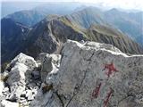 111
111
Discussion about the trip Plöckenhaus - Polinik (path 403)
To post a comment you must log in:
If you do not yet have a username, you must first
register.