| Railway station Sevnica - Lisca (From Sevnica over Zajčja Gora to Lisca)
Lisca is a panoramic peak located north of Sevnica. From the summit, where a meteorological radar station stands, there are fine views of Posavsk...
2 h 50 min |
 | Sevnica - Lisca (via Zajčja Gora and Skalce)
Lisca is a panoramic peak located north of Sevnica. From the summit, where a meteorological radar station stands, there are fine views of Posavsk...
2 h 55 min |
| Sevnica - Lisca (via Zajčja Gora and on Pastirčkova pot)
Lisca is a panoramic peak located north of Sevnica. From the summit, where a meteorological radar station stands, there are fine views of Posavsk...
3 h |
| Sevnica - Lisca (over Zajčja Gora and past Sveti Jošt)
Lisca is a panoramic peak located north of Sevnica. From the summit, where a meteorological radar station stands, there are fine views of Posavsk...
3 h |
 | Zidani Most - Veliko Kozje
Veliko Kozje is a peak located west of Zidani Most. From the summit, which has a logbook box, there is a fine view of the Zasavje and Posavje hil...
2 h 30 min |
 | Zamedveje - Korada
Korada is a panoramic peak west of the Soča River and on the northern edge of Goriška Brda. From the summit, which has a summit logbox, there is ...
2 h 30 min |
 | Radeče - Nebeška gora
Nebeška gora is the highest peak of the Radeče ob Savi municipality. At the summit there is a logbook, stamp, luck bell, and some benchesall plac...
2 h 45 min |
| Zidani Most - Nebeška gora (eastern path)
Nebeška gora is the highest peak of the Radeče ob Savi municipality. At the summit there is a logbook, stamp, luck bell, and some benchesall plac...
2 h 40 min |
| Zidani Most - Nebeška gora (western path)
Nebeška gora is the highest peak of the Radeče ob Savi municipality. At the summit there is a logbook, stamp, luck bell, and some benchesall plac...
2 h 45 min |
 | Zidani Most - Sveta Marija (Ključevica)
The Church of St. Mary is located on a hill called Ključevica, which rises 1,067 meters above sea level. From the partly vegetated summit, there ...
2 h 30 min |
| Radeče - Sveta Marija (Ključevica)
The Church of St. Mary is located on a hill called Ključevica, which rises 1,067 meters above sea level. From the partly vegetated summit, there ...
3 h 10 min |
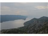 | Bilopolje - Sveti Ilija (Pelješac)
Sveti Ilija, also Zmijino brdo, is a 961-meter-high mountain and the highest peak of the Pelješac Peninsula. From the top, a nice view opens up o...
2 h 20 min |
 | Railway station (Most na Soči) - Veliki vrh (above Lom)
Veliki vrh is located on the northeastern part of the Banjška planota plateau, which rises above Čepovani dol, the Soča river valley, and the Idr...
3 h 15 min |
 | Pásztó - Muzsla (path marked with green plus)
Muzsla (Mužlo) is the highest peak in the western part of the Mátra Mountains, which also include Hungary's highest peak Kékestető. A concrete to...
3 h 15 min |