| Railway station Sevnica - Lisca (From Sevnica over Zajčja Gora to Lisca)
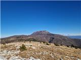
Lisca is a panoramic peak located north of Sevnica. From the summit, where a meteorological radar station stands, there are fine views of Posavsk...
2 h 50 min |
 | Sevnica - Lisca (via Zajčja Gora and Skalce)
Lisca is a panoramic peak located north of Sevnica. From the summit, where a meteorological radar station stands, there are fine views of Posavsk...
2 h 55 min |
| Sevnica - Lisca (via Zajčja Gora and on Pastirčkova pot)
Lisca is a panoramic peak located north of Sevnica. From the summit, where a meteorological radar station stands, there are fine views of Posavsk...
3 h |
| Sevnica - Lisca (over Zajčja Gora and past Sveti Jošt)
Lisca is a panoramic peak located north of Sevnica. From the summit, where a meteorological radar station stands, there are fine views of Posavsk...
3 h |
 | Gračnica - Sveti Lovrenc (above Okroglice) (past Mlinarič)
The Church of St. Lovrenc is located east of Zidani Most and northwest of Sevnica, above the village of Okroglice and near the Lovrenc peak. From...
3 h |
 | Rimske Toplice - Dom v Gorah (via Ogeški potok)
The Dom v Gorah mountain hut is located east of Hrastnik, just a few meters below the 786 m high peak where the church of St. Jurij stands. From ...
2 h 40 min |
| Rimske Toplice (Šmarjeta) - Dom v Gorah (via Lurd)
The Dom v Gorah mountain hut is located east of Hrastnik, just a few meters below the 786 m high peak where the church of St. Jurij stands. From ...
2 h 40 min |
 | Zamedveje - Korada
Korada is a panoramic peak west of the Soča River and on the northern edge of Goriška Brda. From the summit, which has a summit logbox, there is ...
2 h 30 min |
 | Radeče - Nebeška gora
Nebeška gora is the highest peak of the Radeče ob Savi municipality. At the summit there is a logbook, stamp, luck bell, and some benchesall plac...
2 h 45 min |
| Zidani Most - Nebeška gora (eastern path)
Nebeška gora is the highest peak of the Radeče ob Savi municipality. At the summit there is a logbook, stamp, luck bell, and some benchesall plac...
2 h 40 min |
| Zidani Most - Nebeška gora (western path)
Nebeška gora is the highest peak of the Radeče ob Savi municipality. At the summit there is a logbook, stamp, luck bell, and some benchesall plac...
2 h 45 min |
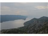 | Bilopolje - Sveti Ilija (Pelješac)
Sveti Ilija, also Zmijino brdo, is a 961-meter-high mountain and the highest peak of the Pelješac Peninsula. From the top, a nice view opens up o...
2 h 20 min |
 | Rimske Toplice - Vrhe (at Gore) (via Ogeški potok)
Vrhe is a forested 781-meter-high peak located northwest of the Planinski dom hut in Gore....
2 h 50 min |
| Rimske Toplice (Šmarjeta) - Vrhe (at Gore) (via Lurd)
Vrhe is a forested 781-meter-high peak located northwest of the Planinski dom hut in Gore....
2 h 50 min |
 | Mošćenice - Kremenjak (past Kalvarija)
Kremenjak is a scenic rocky peak on Učka. The peak is a point on the Istrian Mountain Path. From the peak, which has a summit book box and a bord...
2 h 45 min |
| Mošćenice - Kremenjak (on marked path)
Kremenjak is a scenic rocky peak on Učka. The peak is a point on the Istrian Mountain Path. From the peak, which has a summit book box and a bord...
2 h 40 min |
 | Mošćenice - Planinsko zavetišče Kremenjak (past Kalvarija)
The Kremenjak Mountain Shelter is located on a small peak between Kremenjak and Brgud. The bivouac is of quite unusual shape and has some benches...
2 h 45 min |
| Mošćenice - Planinsko zavetišče Kremenjak (on marked path)
The Kremenjak Mountain Shelter is located on a small peak between Kremenjak and Brgud. The bivouac is of quite unusual shape and has some benches...
2 h 40 min |
 | Mošćenice - Brgud (past Kalvarija and Kremenjak)
Brgud is a scenic peak on Učka. The peak is a point of the Istrian Mountain Path. At the highest point of the peak, there is only a pile of stone...
3 h 15 min |
| Mošćenice - Brgud (along the marked trail and past Kremenjak)
Brgud is a scenic peak on Učka. The peak is a point of the Istrian Mountain Path. At the highest point of the peak, there is only a pile of stone...
3 h 10 min |
 | Mošćenice - Balin (past Kalvarija and via Brgud)
Balin is a less known peak on Učka between Brgud and Maj. From the peak, there is a beautiful view of the Kvarner, part of Istria, and the Učka r...
3 h 45 min |
| Mošćenice - Balin (on marked path and via Brgud)
Balin is a less known peak on Učka between Brgud and Maj. From the peak, there is a beautiful view of the Kvarner, part of Istria, and the Učka r...
3 h 40 min |