Similar trips - Radeljski prelaz - Sveti Anton na MP Radelj / St. Anton am Radlpaß
 | Sveta Katarina (Zgornja Kapla) - Tolsti vrh (on Kozjak)
Tolsti vrh is a 756-meter-high peak on Kozjak, located on the Austria-Slovenia border north of Zgornja Kapla settlement. The summit lies in fores...
30 min |
 | Noršić selo - Noršićka Plešivica
Noršićka Plešivica is a partially forested hill in the northwestern part of the Samoborsko gorje. The summit is an alternative HPO point near Vel...
25 min |
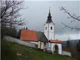 | Štefanja Gora - Štefanja gora (via Zgornja Štefanja vas)
Štefanja gora, where the Church of St. Stephen stands, is located above Cerklje na Gorenjskem. Just a few tens of meters below the summit lies th...
35 min |
 | Maria Rain / Žihpolje - Aussicht Petelinz
The Petelinz viewpoint (Aussicht Petelinz) is located northeast of Borovelj/Ferlach, north of or directly above the Drava/Drau River. From the vi...
35 min |
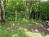
 | Branček - Sveta Katarina above Novokračine
The chapel of St. Katarina is located on the eponymous hill southwest of Novokračine, a settlement near the Slovenian-Croatian border. From the s...
30 min |
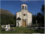 | Breginj - Marija Snežna in Breginjski kot
The Church of Marija Snežna in Breginjski kot is situated on a small hill above Breginj. From the church, beside which there is also a cemetery, ...
25 min |
| Odomovo jezero - Tolsti vrh (on Kozjak)
Tolsti vrh is a 756-meter-high peak on Kozjak, located on the Austria-Slovenia border north of Zgornja Kapla settlement. The summit lies in fores...
22 min |
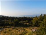
 | Rašpor - Vrtelj
Vrtelj is an indistinct, forest-covered peak located on the Obiteljska staza Marećica path between Kosmatica and Vidikovec Prapoće....
35 min |
 | Leskovec - Kucelj
Kucelj is a 748-meter-high peak situated north of Višnja gora. From the summit, where there is a small geodetic tower with a nearby stamp, there ...
25 min |