 | Tolminske Ravne - Mahavšček (via Dobrenjščica)
Mahavšček, or Veliki Bogatin, is a 2008 m high mountain on the northwestern edge of the Lower Bohinj Mountains. From the summit, with its somewha...
5 h 15 min |
 | Koča pri Savici - Velika Zelnarica (via Vrata)
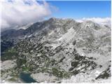
Velika Zelnarica is a 2320 m high peak west of the Vrata saddle, which separates the Valley of the Triglav Lakes from the Za Kopico valley. A sma...
6 h 40 min |
 | Koča pri Savici - Velika Zelnarica (via Štapce)
Velika Zelnarica is a 2320 m high peak west of the Vrata saddle, which separates the Valley of the Triglav Lakes from the Za Kopico valley. A sma...
6 h 30 min |
 | Koča pri Savici - Kopica (via Štapce)
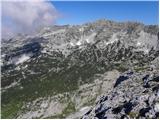
Kopica is a peak located between Velika Tičarica and Mala Zelnarica. From the summit, there is a nice view toward the Valley of the Triglav Lakes...
5 h 15 min |
 | Grant - Raskovec (via Rodica)
Raskovec is a panoramic mountain between the more prominent Rodica and Črna prst. Its seldom-visited summit lacks a logbook or stamp but delivers...
4 h 30 min |
 | Na Razpotju - Lučka Brana (Baba)
Lučka Brana (Baba) is a less prominent peak located in the ridge between Planjava and Ojstrica. From its expansive and partly grassy summit, ther...
4 h 10 min |
 | Koča pri Savici - Vrh Hribaric
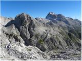
Vrh Hribaric is a 2,388-meter-high mountain located between Vršaki, Kanjavec, Mišeljski Konec, Škednjovec, and Debeli Vrh. From the summit, marke...
6 h 20 min |
 | Koča pri Savici - Vršaki (Vzhodni vrh)
The eastern peak of Vršaki (the first from Hribaric) is a 2,448-meter-high mountain situated between Kanjavec, Debeli Vrh, and Zadnji Vogel. From...
6 h 20 min |
 | Koča pri Savici - Vodnikov Vršac (Vršac nad Zadnjico)
Vodnikov Vršac, also known as Vršac nad Zadnjico, is a 2194-meter-high mountain that drops precipitously toward the Zadnjiški dol valley. From th...
5 h 50 min |
 | Koča pri Savici - Glava za Bajto (via Dvojno jezero)
Glava za Bajto is a panoramic peak above Zgornja Komna, offering fine views of the Julian Alps....
6 h 30 min |
 | Sankt Ilgen (Der Bodenbauer) - Hochwart (via bivouac Fleischer)
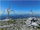
Hochwart is a pathless 2,210-meter-high peak in the Hochschwab mountain group. From the summit, where a cross and summit register box are located...
4 h 55 min |
 | Sankt Ilgen (Der Bodenbauer) - Zagelkogel (via bivouac Fleischer)
Zagelkogel is a 2255-metre-high peak located in the Hochschwab mountain group. From the summit, where a cross is erected, a beautiful view opens ...
4 h 35 min |
 | Sankt Ilgen (Der Bodenbauer) - G'hacktkogel
G'hacktkogel is a panoramic peak in the Hochschwab mountain group, located above the Fleischer bivouac or, more precisely, between the peaks of G...
4 h 5 min |