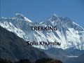
 | Solukhumbu Trekking Part III
16. 11. 2011 18:11:18
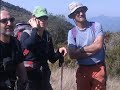
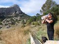
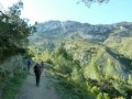
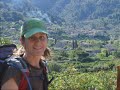
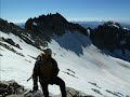
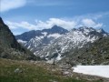
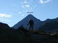
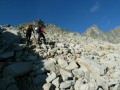
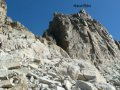
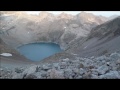
From Gokyo to Chukhung via Cho La (3 stages)rTrack on Wikiloc: (broken down into 18 stages):rhttp://es.wikiloc.com/wikiloc/view.do?id=2196222... |
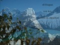 | Solukhumbu Trekking Part IV
16. 11. 2011 18:20:37
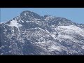
Island Peak (3 stages)rTrack on Wikiloc: (broken down into 18 stages):rhttp://es.wikiloc.com/wikiloc/view.do?id=2196222... |
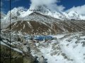 | Solukhumbu Trekking Part V
21. 11. 2011 16:46:46
From Dingboche to Deboche via KalaPattar (3 stages)rTrack on Wikiloc: (broken down into 18 stages):rhttp://es.wikiloc.com/wikiloc/view.do?id=2196222... |
 | Solukhumbu Trekking Part VI
21. 11. 2011 17:46:34
From Deboche to Lukla (3 stages)rTrack on Wikiloc: (broken down into 18 stages):rhttp://es.wikiloc.com/wikiloc/view.do?id=2196222... |
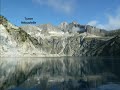
 | See you in 2012
26. 12. 2011 09:50:22
Images from 2011 to share with our friends... |
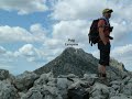
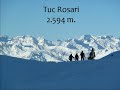 | Tuc Rosari (2,594 m)
11. 01. 2012 09:11:11
Ascent from the Orri parking lot to Tuc Rosari.rTrack on Wikiloc: http://es.wikiloc.com/wikiloc/view.do?id=2378803... |
 | La Serrella and Pla de la Casa from Quatretondeta
26. 01. 2012 15:40:40
Track on Wikiloc: http://es.wikiloc.com/wikiloc/view.do?id=2422961... |
 | Peña Saganta from Espadilla
31. 01. 2012 12:05:29
Track on Wikiloc: http://es.wikiloc.com/wikiloc/view.do?id=2445455... |
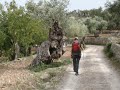
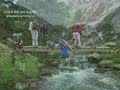
 | Villages of la Tinença
28. 03. 2012 13:23:33
Three-day route between Bel-Vallibona-Coratxà-El Boixar-La Pobla de Benifassà-BelrTrack on Wikiloc: http://es.wikiloc.com/wikiloc/view.do?id=2624664... |
 | Serra d'En Galceran | Tossal Saragossa and Roca del Figueral
3. 04. 2012 13:02:40
Ascent from Els Rosildos to Tossal Saragossa via Barranco de la Roca Roja, descent via Mas Gargallo, Capó and Paula to Roca Figueral. Via ferrata and Tibetan bridge optional.rTrack on Wikiloc: http://es.wikiloc.com/wikiloc/view.do?id=2667105... |
 | Aitzgorri, Aketegi and Aitxuri from Arantzazu. Provincial roof of Guipúzcoa
4. 04. 2012 11:58:26
Track on Wikiloc: http://es.wikiloc.com/wikiloc/view.do?id=2668198... |
 | Aldamin and Gorbeia from the Murua quarry. Provincial roof of Álava and Vizcaya
4. 04. 2012 12:43:18
Track on Wikiloc: http://es.wikiloc.com/wikiloc/view.do?id=2668205... |
 | Maigmó from El Portell de Catí
12. 04. 2012 14:56:48
Track on Wikiloc: http://es.wikiloc.com/wikiloc/view.do?id=2699755... |
 | Els escarrissons de Borosa and Barretes - Els Ports
13. 04. 2012 08:20:59
Circular route that covers the head of the Lloret ravine accessing and descending from its upper part via 'els escarrissons'.rTrack on Wikiloc: http://es.wikiloc.com/wikiloc/view.do?id=2699764... |
 | Mola Grossa, Tossal d'Engrilló and Punta l'Aigua via Forat de la Finella - Els Ports
13. 04. 2012 08:31:54
From Paúls ascent to these three summits passing by the 'fonts del Montsagre'.rTrack on Wikiloc: http://es.wikiloc.com/wikiloc/view.do?id=2699843... |
 | Roca de Migdia | Mola Castellona | Els Ports: Barranc de la Caramella
20. 04. 2012 09:20:02
Track on Wikiloc: http://es.wikiloc.com/wikiloc/view.do?id=2730217... |
 | Grau Salfores | Clot Cirer | Piló | Toll l'Ou | Roca Falconera | Montsant: Grau Agnet
20. 04. 2012 09:34:10
Track on Wikiloc: http://es.wikiloc.com/wikiloc/view.do?id=2730221... |
 | Tosques | Cova Gralles | Pont Goi | Font Nova | Cova Grévol | Foradada | Prades: Capafonts
20. 04. 2012 10:01:04
Track on Wikiloc: http://es.wikiloc.com/wikiloc/view.do?id=2730230... |
 | La Pandilla Basura at Benicadell
8. 05. 2012 14:43:16
Ascent from Beniatjar to Benicadell... |
 | Penyagolosa from Sant Joan via the channels of the south face
8. 05. 2012 14:48:04
Track on Wikiloc: http://es.wikiloc.com/wikiloc/view.do?id=2806927... |
 | Valldemossa-Deià - Tramuntana (1/5)
10. 05. 2012 16:25:10
Stage track: http://es.wikiloc.com/wikiloc/view.do?id=2786421rComplete track: http://es.wikiloc.com/wikiloc/view.do?id=2806846... |
 | Deià-Ref. Muleta (Port de Sóller) - Tramuntana (2/5)
10. 05. 2012 16:30:21
Stage track: http://es.wikiloc.com/wikiloc/view.do?id=2786422rComplete track: http://es.wikiloc.com/wikiloc/view.do?id=2806846... |
 | Ref. Muleta-Ref. Tossals Verds - Tramuntana (3/5)
10. 05. 2012 16:53:38
Stage track: http://es.wikiloc.com/wikiloc/view.do?id=2786423rComplete track: http://es.wikiloc.com/wikiloc/view.do?id=2806846... |
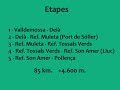 | Ref. Tossals Verds-Ref. Son Amer (Lluc) - Tramuntana (4/5)
10. 05. 2012 17:00:16
Stage track: http://es.wikiloc.com/wikiloc/view.do?id=2786425rhttp://es.wikiloc.com/wikiloc/view.do?id=2806846... |
 | Ref. Son Amer-Pollença - Tramuntana (5/5)
10. 05. 2012 17:09:49
Stage track: http://es.wikiloc.com/wikiloc/view.do?id=2786427rComplete track: http://es.wikiloc.com/wikiloc/view.do?id=2806846... |
 | Serra Gelada
4. 06. 2012 09:07:46
Track on Wikiloc: http://es.wikiloc.com/wikiloc/view.do?id=2865608... |
 | Ponoig via Coll de Cova Moscarda, Cabal, Sanxet, el Salt, Racó Tovaines
4. 06. 2012 09:10:45
Track on Wikiloc: http://es.wikiloc.com/wikiloc/view.do?id=2865611... |
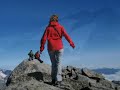
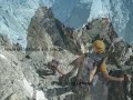
 | Eastern Maladeta (3.308 m.) via Collado de la Rimaya + Torre Cordier (3.046 m.)
4. 06. 2012 11:39:58
Track on Wikiloc: http://es.wikiloc.com/wikiloc/view.do?id=2891084This activity is part of the project: Pyrenees - Our 212 three-thousandersMore information: http://www.blurb.es/b/4199300-pirineos-nuestros-212-tresmiles... |
 | Forquetas + Tuca Forao de la Neu from Espigantosa
4. 06. 2012 14:52:10
From Espigantosa parking ascent to Ibón de Llardaneta. From there we split: one side to Forquetas and the other to Tuca del Forao de la Neu, taking photos of each other.Track on Wikiloc to the Tuca: http://es.wikiloc.com/wikiloc/view.do?id=2902814... |
 | Pic Lustou (3,023m) from Rioumajou
5. 06. 2012 12:41:44
Track on Wikiloc: http://es.wikiloc.com/wikiloc/view.do?id=2926575Ascent from Fredançon (1,380 m) in the Rioumajou valley to Pic Lustou (3,023 m).3h 35m ascent, 2h 20m descent and the 40m at the summit total 6h 35m of activity.... |
 | Tempestades Ridge (from Tempestades to Aneto)
21. 06. 2012 11:22:15
Track on Wikiloc: http://es.wikiloc.com/wikiloc/view.do?id=2978345From Pico Tempestades descent along the same ridge (Bavarian step) then through Llosás side and Barrancs side past various gendarmes before reaching the foot of Punta Brecha Tempestades (peak with a more orange rock color). Via the se... |
 | Round of Néouvielle (Cap Long-Ref. Glère-Turón Néouvielle-Ref. Glère-Lac d'Aubert
3. 07. 2012 14:24:56
Round of Pico Néouvielle in three days, with ascent to Turon de Néouvielle.rTrack on Wikiloc: http://es.wikiloc.com/wikiloc/view.do?id=3011347... |
 | Picos Cufreda (Batoua) from Rioumajou
9. 07. 2012 09:02:30
Track on Wikiloc: http://es.wikiloc.com/wikiloc/view.do?id=3011330Circular ascent to the 3 Culfredas peaks from Gredançon (Rioumajou) via Cortail de Batoua, returning via Puerto de la Madera and Hospice de Rioumajou... |
 | Bardamina Ridge (Pico Bardamina, Pico Paúl and Pico Inf. Paúl)
10. 07. 2012 09:48:00
Track on Wikiloc: http://es.wikiloc.com/wikiloc/view.do?id=3016529Ascent from Espigantosa to the Bardamina ridge, descending via Estós.This activity is part of the project: Pyrenees - Our 212 three-thousanders... |
 | Western Maladetas (Punta Delmás, Mir, Sayo, Cordier, Le Bondidier, Diente and Muela del Alba)
10. 07. 2012 13:37:57
Track on Wikiloc: http://es.wikiloc.com/wikiloc/view.do?id=3027306Ascent from Besurta (out and back) to these 7 official three-thousanders and the ghost of Le Bondidier NorteThis activity is part of the project: Pyrenees - Our 212 three-thousanders... |
 | La Pandilla Basurilla via the Pica
12. 07. 2012 13:32:02
Track first day: http://es.wikiloc.com/wikiloc/view.do?id=3058812Track second day: http://es.wikiloc.com/wikiloc/view.do?id=3058816Ascent to Rodo de Canalbona (3.004 m.) and Punta Gabarró (3.115 m.) overnight at Estany d'Estats to do the next day Sotllo (3.072 m.) and Sotllo N. (3.058 m.)... |
 | Peña Montañesa via Toro ledge
24. 07. 2012 09:31:35
Track on Wikiloc: http://es.wikiloc.com/wikiloc/view.do?id=3041280... |
 | Finger of Monte Perdido, Monte Perdido, Espalda Esparets and Punta de las Olas
25. 07. 2012 08:17:54
Track on Wikiloc: http://es.wikiloc.com/wikiloc/view.do?id=3107820From the bus that from Nerín goes up to the vicinity of Cuello Gordo, ascent to the Finger of Monte Perdido 3.188 m. (two pitches of climbing on rock of very poor quality), continuing to the summit of Monte Perdido 3.355 m. Descent to... |
 | Ridge of Pic Trois Conseillers to Punta Reboul Vidal
25. 07. 2012 10:00:40
Track on Wikiloc: http://es.wikiloc.com/wikiloc/view.do?id=3112859From Cap de Long reservoir out-and-back ascent via Brecha de Néouvielle to Pic Trois Conseillers (3039 m.), then along the ridge, passing Premier Conseiller, to Turon de Néouvielle (3035 m.). Descent to Punta Reboul Vidal (3006 m.). R... |
 | Pic Maubic, Tourrat Needle, Pic Long, Badet Needle, Pic Badet and Pic Maou
25. 07. 2012 12:47:12
Track on Wikiloc: http://es.wikiloc.com/wikiloc/view.do?id=3108938From Cap de Long reservoir ascent to Pic Maubic (3058 m.). Out and back to Aguja Tourrat (3014 m.) to then from Pic Maubic tackle the Arista de Cap de Long to Pic Long (3192 m.). We follow the ridge passing Aguja Badet (3135 m.), Pic ... |
 | Superior and Inferior Needles of Clot de la Hount and SW Needle of Cerbillona
25. 07. 2012 14:36:30
Track on Wikiloc: http://es.wikiloc.com/wikiloc/view.do?id=3109019From Bayssellance refuge (where we had climbed the previous day) ascent to Pic Clot de la Hount (3298 m.). Descent down the West wall to the so-called most inhospitable 3,000s of the Pyrenees, Aguja Superior e Inferior de Clot de la H... |
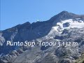 | Pic Milieu, Grand Tapou and Lower and Upper Tapou Points
26. 07. 2012 11:13:49
Track on wililoc: http://es.wikiloc.com/wikiloc/view.do?id=3109110From Barrage d'Ossoue ascent via Montferrat lakes to Pic du Milieu (3130 m.). We continue to Grand Pic de Tapou (3150 m.) to then tackle the ascent to Punta Superior de Tapou (3132 m.) and Punta Inferior de Tapou (3124 m.). Return to ... |
 | Gran Facha and Pequeña Facha
26. 07. 2012 12:12:08
Track on Wikiloc: http://es.wikiloc.com/wikiloc/view.do?id=3112868From Respomuso refuge ascent via Facha col to Gran Facha (3005 m.) and then to Pequeña Facha (2948 m.)... |
 | Frondella SW (3011 m.)
26. 07. 2012 12:18:15
Track on Wikiloc: http://es.wikiloc.com/wikiloc/view.do?id=3112870From Respomuso refuge via Arriel lakes ascent to Frondella SW (3011 m.), descending to Sarra reservoir... |
 | Alba Gendarme (3054 m.) and Alba Peak (3118 m.)
29. 08. 2012 09:25:32
Track on Wikiloc: http://es.wikiloc.com/wikiloc/view.do?id=3265867Out-and-back ascent from Besurta to Gendarme de Alba and then to Pico de AlbaThis activity is part of the project: Pyrenees - Our 212 three-thousanders... |
 | Argarot Needle, Tchihatcheff Needle and Franqueville Needle - Llosas Ridge Needles
29. 08. 2012 09:31:22
Track on Wikiloc: http://es.wikiloc.com/wikiloc/view.do?id=3265870Ascent from Cabaña de Pescadores (Vallibierna) to Ibón Inf. de Coronas to climb towards the lower Llosás gap. Before reaching it, direct ascent to Agujas Argarot Sur and Argarot (3035 m.). Downclimb to the next gap to lose some height... |
 | Salenques Ridge
30. 08. 2012 08:23:41
Track on Wikiloc: http://es.wikiloc.com/wikiloc/view.do?id=3265884From Besurta, where we arrived on the first bus of the morning, ascent via Barrancs directly to Forca Estasen (3028 m.). From here we start the ridge passing Torre Salenques (3111 m.), Primer Resalte Salenques (3127 m.), Segundo Resal... |
 | Besiberris Ridge
30. 08. 2012 08:27:21
Track on Wikiloc: http://es.wikiloc.com/wikiloc/view.do?id=3265895From Estany de Malavesina, where we had climbed up to sleep the previous afternoon, ascent along the ridge to Besiberri Nord (3014 m.), continuing along the crest to Besiberri del Mig N or Pic Simó (3002 m.) and Besiberri del Mig S. o... |
 | Aguja Haurillón, Aguja Cregüeña, Aguja Juncadella and Pico Aragüells - Needles of Cregüeña Crest
31. 08. 2012 08:51:14
Track on Wikiloc: http://es.wikiloc.com/wikiloc/view.do?id=3265899From Cabaña de Pescadores de Vallibierna we climbed through the ibones de Coronas directly to the gap between Aguja Haurillón and Aguja Cregüeña. After two climbing pitches (IV) we climbed to Aguja Haurillón (3075 m.). We rappelled ba... |
 | Cresta Lézat
31. 08. 2012 08:58:06
Track on Wikiloc: http://es.wikiloc.com/wikiloc/view.do?id=3265911From the Refugio de Portillón, where we had climbed the previous afternoon from Les Granges d'Astau, we climbed towards Collado Inf. de Literola to reach Brecha Mamy. From there, Punta Mamy (3048 m.), Punta Lacq (3010 m.), Aguja Inf. ... |