|
| panda20. 11. 2011 09:25:20 |
|
|
|
|
| drago4020. 11. 2011 21:39:54 |
In the list of 2000ers in the PZS calendar and in D. Ipavec's booklet, Perilnik is 2000m, the M&M list has 2022.0m or 2040.9m source: Klinar.
On picture 3 is the area where Perilnik is, if 2000m then the saddle picture 4, if higher it could be the summit. But I don't trust my altimeter, relative heights can be estimated. The entire ridge from Veliki vrh to Tolsta Košuta I walked and no dilemmas except at Perilnik.
Sorry for spamming. Regards
|
|
|
|
| Laščan26. 11. 2011 18:21:30 |
Tomorrow we plan to visit Košutnikov Turn with the group. Starting point should be Planina Dolga Njiva, wondering (we'd do a circular tour), up the eastern or western variant? Was anyone at this summit today and knows the conditions on the path? Thanks for answer in advance, and nice hiking day tomorrow to all!!
|
|
|
|
| keber126. 11. 2011 18:33:39 |
I recommend up the eastern variant, because it's a bit steeper (but also shorter). Regarding conditions, it's written on the previous page that the path is completely dry, sun is shining in the mountains for several weeks in a row.
|
|
|
|
| ksena5. 03. 2012 12:47:58 |
On Saturday, 4.3., we did a nice tour to Košutnikov Turn. Tržič - Jelendol - Medvodje....road from Medvodje to Košutnik is snowy in places and icy too, so we didn't persist to the official parking with the car. Then to Planina Dolga Njiva. The path is well marked, but in places with lots of snow we just guessed it. Guessed well, since we reached the summit without problems. If, of course, wading almost to the waist (in certain places) is not considered a problem  . Otherwise, the path is mostly dry at the beginning, later snow to the ankles, only in gullies larger amounts of southern snow. And those gullies need to be crossed . Otherwise, the path is mostly dry at the beginning, later snow to the ankles, only in gullies larger amounts of southern snow. And those gullies need to be crossed  . We recommend the tour to all lovers of solitary paths, of course for now still with winter gear. . We recommend the tour to all lovers of solitary paths, of course for now still with winter gear.
On the way we found Olympus camera lens cap....if someone misses it, send me PM.
 1 1 2 2 3 3 4 4 5 5 6 6 7 7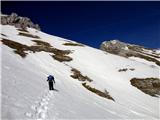 8 8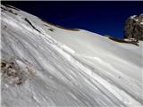 9 9 10 10 11 11 12 12 13 13 14 14 15 15") 16 16 17 17 18 18") 19 19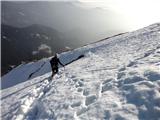 20 20") 21 21 22 22
| (+2) |  | |
|
|
|
|
| ljubitelj gora5. 03. 2012 13:59:02 |
Košuta is considered avalanche terrain, how come you chose Košutnikov turn and, judging by pic 9, for further ascent 
| (+2) | | |
|
|
|
|
| ksena5. 03. 2012 14:05:25 |
Problematic spots we crossed where we assessed it was safest. If it had not been safe, we certainly wouldn't have continued the path.
| (+2) | | |
|
|
|
|
| tinky20. 05. 2012 19:18:15 |
Sorok and I did it today up the western to Košutnikov turn. Before Koštnik water washed away part of the road so we parked before the landslide, which extended the tour by half an hour. (one way). Down we went by the eastern path with a stop at planina Dolga Njiva. Weather nice, on the summit a bit windy and some snow patches still here and there. At Dolga Njiva, buckwheat mush, sour cabbage, ribs and cheese struklji. Pictures follow.
|
|
|
|
| Sorok20. 05. 2012 20:24:26 |
...and the following pictures
If I misidentified the rose, please correct me!
|
|
|
|
| katty28. 05. 2012 11:35:38 |
Košutnikov Tur(e)n can be a standalone tour, or we can step onto it after having already traversed quite a good part of the ridge. Somehow this year I was more drawn to traverse the entire ridge, from Košutica all the way to Tolsta Košuta . In one day, of course with an early start . In one day, of course with an early start . This time we decide for the standalone summit, well yeah, maybe we'd go to Tolsta Košuta too. We start from the parking lot at the quarry. Several hikers had already started ahead of us, so these areas will see visitors. Planina Dolga Njiva is really beautiful and enchanting. A true mountain idyll under Košuta . This time we decide for the standalone summit, well yeah, maybe we'd go to Tolsta Košuta too. We start from the parking lot at the quarry. Several hikers had already started ahead of us, so these areas will see visitors. Planina Dolga Njiva is really beautiful and enchanting. A true mountain idyll under Košuta . We continue on the western path. Above the forest line, real genuine botanical surprises: auriculas teem in the rocks, on the bare slopes countless gentians(I've never seen so many) and edelweiss. At the beauties I just stop... even for a minute and more. After numerous zigzags we're finally at the saddle where the climbing path joins. We're alone. The view of Stegovnik, where we were on Saturday, and the KSA peaks is magnificent, despite some cumulus clouds. The steepness increases slowly and persistently, so hands are needed. The path is quite crumbly in places, so you have to be a bit more careful. With persistence we go on. Soon I'm at the top. Happiness and joy are indescribable, the panorama enchanting. Peace and quiet add a special charm. It's beautiful. We descend the same path. We meet a trio that ascended to KT via the difficult path past Cjajnik, then an Austrian mountaineer puffs up, whom we watched climbing the more difficult path. Everyone heads to the top. On the way back to the start we also stop at Planina Spodnja Dolga Njiva, where all the stamps are-Košutnikov Turn, Tolsta Košuta and Plešivec. . We continue on the western path. Above the forest line, real genuine botanical surprises: auriculas teem in the rocks, on the bare slopes countless gentians(I've never seen so many) and edelweiss. At the beauties I just stop... even for a minute and more. After numerous zigzags we're finally at the saddle where the climbing path joins. We're alone. The view of Stegovnik, where we were on Saturday, and the KSA peaks is magnificent, despite some cumulus clouds. The steepness increases slowly and persistently, so hands are needed. The path is quite crumbly in places, so you have to be a bit more careful. With persistence we go on. Soon I'm at the top. Happiness and joy are indescribable, the panorama enchanting. Peace and quiet add a special charm. It's beautiful. We descend the same path. We meet a trio that ascended to KT via the difficult path past Cjajnik, then an Austrian mountaineer puffs up, whom we watched climbing the more difficult path. Everyone heads to the top. On the way back to the start we also stop at Planina Spodnja Dolga Njiva, where all the stamps are-Košutnikov Turn, Tolsta Košuta and Plešivec.
First time in this end of Košuta. It didn't disappoint me, quite the opposite. Next time maybe to Tolsta Košuta. It looks mighty.
A few more snapshots...
 1 1 2 2") 3 3 4 4 5 5 6 6 7 7 8 8") 9 9 10 10 11 11 12 12 13 13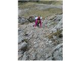 14 14 15 15 16 16 17 17)") 18 18 19 19 20 20 21 21 22 22 23 23 24 24 25 25") 26 26 27 27 28 28 29 29 30 30 31 31 32 32 33 33 34 34") 35 35
| (+5) | | |
|
|
|
|
| Jany19. 07. 2012 08:28:53 |
I'm interested in how you descended? Same way, or is a loop possible? I'm heading there anyway.
Nice photos you took!
Best
|
|
|
|
| urbancek19. 07. 2012 09:07:02 |
Going up I didn't go over the little bridge (the ferrata has two branches in the lower part up to the bridge - the entrances are say a couple of 10m apart -> that's practical because there can be "two-way traffic" there and it's safer), going down over the little bridge and along the other "branch" to the scree... The only loop is possible if you go along the Košuta ridge to Cjajnik and descend via Cjajnik's "western" rocky ridge into the forest to avoid the scree, since the usual path is closed due to landslide... Here I also ask if the landslide has anything to do with the described variant? In my opinion no, because you descend far west along the ridge into the forest and are not in contact with the scree?? Best!
|
|
|
|
| urbancek19. 07. 2012 09:39:10 |
@LG: I believe Jany also has some map at home or ultimately on the internet. But I don't know what this has to do with it (or how it would help Jany), if almost half the paths on your map are closed??!
P.S: And he asked about a loop, so those paths from Planina Dolga Njiva have absolutely no connection...
|
|
|
|
| ljubitelj gora19. 07. 2012 09:44:49 |
I knew you'd reply, but is it even necessary, lately you always do this over and over, I added the map because I haven't gone from the Austrian side yet and forgot to ask if all those drawn paths are possible, one is missing on the far right anyway (geopedia), those dots I know lead to Cjajnik, which path is currently closed.
|
|
|
|
| urbancek19. 07. 2012 09:46:48 |
The eastern path to the Turn is also closed, which is also drawn in... What should I do if you post inaccuracies?
|
|
|
|
| ljubitelj gora19. 07. 2012 09:55:41 |
You at least have the edit function, I don't even have that.
|
|
|
You must log in to post a comment:
If you do not yet have a username, you must first
register.