 | Jamce - Sinji vrh (west path)
Sinji vrh is a panoramic mountain between Col, Ajdovščina, and Predmeja. It offers views across much of western Slovenia (the sea on clear days)....
2 h 45 min |
 | Cerkno - Bevkov vrh (via Lajše)
Bevkov vrh, a control point on the Slovenian Mountain Trail, is located between Cerkno and Spodnja Idrija. The peak is forested, but the stamp is...
3 h |
 | Vitovlje - Čaven (via Vitovlje Lake)
Čaven is a forested peak located west of Veliki Rob (1237 m). No marked trail leads to the summit, despite its very well-known name, even though ...
2 h 40 min |
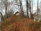
 | Radlje ob Dravi - Kapunar / Kapunerkogel (on unmarked path)
Kapunar is a 1,051-meter-high peak above Radlje ob Dravi. Just below the summit stands an old customs post and border guardhouse, now used by ama...
2 h 15 min |
 | Spodnja Idrija - Gradišče (above Spodnja Idrija) (via Trnje)
Gradišče is a 998 m high peak that separates the Ledinska plateau in the northwestern part of Rovtarsko hribovje from the Idrijca valley. A telev...
2 h 15 min |
 | Zatolmin - Mrzli vrh above Planina Pretovč (via Vodel on Mrzli vrh)
Mrzli vrh is a well-known battlefield from the First World War. Today, the peak is recognised as an open-air museum where numerous caverns, trenc...
3 h 30 min |
 | Loke - Javor
Javor is a 1,132-meter-high peak situated between Kisovec and Sveta Planina. The summit, covered with forest, offers no views, but a nice panoram...
2 h 25 min |
 | Trbovlje - Javor
Javor is a 1,132-meter-high peak situated between Kisovec and Sveta Planina. The summit, covered with forest, offers no views, but a nice panoram...
2 h 30 min |
 | Hrastnik (Podkraj) - Sveta Marija (Ključevica)
The Church of St. Mary is located on a hill called Ključevica, which rises 1,067 meters above sea level. From the partly vegetated summit, there ...
2 h 50 min |
 | Ravne na Koroškem - Pokeržnikov vrh (via Šteharski vrh)
Pokeržnikov vrh is a 1,055-meter-high peak situated above the settlement of Strojna in the Municipality of Ravne na Koroškem. From the summit, wh...
3 h 15 min |
 | Reka (Laze) - Črvov vrh (through the gully of stream Sjaunk (Sejalnik))
Črvov Vrh, also known as Črvov Grič, is the highest peak of the Šentviška Planota at 974 metres. The plateau rises above the right bank of the Id...
2 h 30 min |
 | Ruše - Lamprehtov vrh
Lamprehtov vrh is a 1,230-metre peak in the Pohorje Mountains, located northeast of Klopni vrh....
3 h 40 min |
 | Zgornja Bistrica (Center Vintgar) - Repnikov vrh (via Veliko Tinje)
Repnikov vrh is a 988-meter-high peak on Pohorje, located between Planina pod Šumikom and Urh. The summit is in the middle of the forest, along a...
2 h 45 min |
| Zgornja Bistrica (Center Vintgar) - Repnikov vrh (via Bistriški vintgar)
Repnikov vrh is a 988-meter-high peak on Pohorje, located between Planina pod Šumikom and Urh. The summit is in the middle of the forest, along a...
3 h 15 min |