| Railway station Sevnica - Lisca (From Sevnica over Zajčja Gora to Lisca)
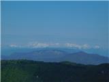
Lisca is a panoramic peak located north of Sevnica. From the summit, where a meteorological radar station stands, there are fine views of Posavsk...
2 h 50 min |
 | Sevnica - Lisca (via Zajčja Gora and Skalce)
Lisca is a panoramic peak located north of Sevnica. From the summit, where a meteorological radar station stands, there are fine views of Posavsk...
2 h 55 min |
| Sevnica - Lisca (via Zajčja Gora and on Pastirčkova pot)
Lisca is a panoramic peak located north of Sevnica. From the summit, where a meteorological radar station stands, there are fine views of Posavsk...
3 h |
| Sevnica - Lisca (over Zajčja Gora and past Sveti Jošt)
Lisca is a panoramic peak located north of Sevnica. From the summit, where a meteorological radar station stands, there are fine views of Posavsk...
3 h |
 | Gračnica - Sveti Lovrenc (above Okroglice) (past Mlinarič)
The Church of St. Lovrenc is located east of Zidani Most and northwest of Sevnica, above the village of Okroglice and near the Lovrenc peak. From...
3 h |
 | Zidani Most - Veliko Kozje (mimo Gašperjeve koče)
Veliko Kozje is a mountain that rises steeply above the left bank of the Savinja River, descending more gently towards the Sava River. The highes...
2 h 40 min |
 | Gračnica - Veliko Kozje
Veliko Kozje is a mountain that rises steeply above the left bank of the Savinja River, descending more gently towards the Sava River. The highes...
2 h 15 min |
 | Breg - Veliko Kozje
Veliko Kozje is a mountain that rises steeply above the left bank of the Savinja River, descending more gently towards the Sava River. The highes...
3 h 15 min |
 | Zamedveje - Korada
Korada is a panoramic peak west of the Soča River and on the northern edge of Goriška Brda. From the summit, which has a summit logbox, there is ...
2 h 30 min |
 | Štore - Tolsti vrh above Celjska koča (via Žlajfa)
Tolsti vrh (also recorded as Tovsti vrh in some sources) is situated above the Celjska koča ski area. The summit has a logbook box and stamp, but...
2 h 15 min |
 | Radeče - Nebeška gora
Nebeška gora is the highest peak of the Radeče ob Savi municipality. At the summit there is a logbook, stamp, luck bell, and some benchesall plac...
2 h 45 min |
| Zidani Most - Nebeška gora (eastern path)
Nebeška gora is the highest peak of the Radeče ob Savi municipality. At the summit there is a logbook, stamp, luck bell, and some benchesall plac...
2 h 40 min |
| Zidani Most - Nebeška gora (western path)
Nebeška gora is the highest peak of the Radeče ob Savi municipality. At the summit there is a logbook, stamp, luck bell, and some benchesall plac...
2 h 45 min |
 | Bilopolje - Sveti Ilija (Pelješac)
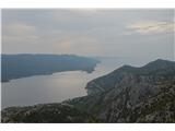
Sveti Ilija, also Zmijino brdo, is a 961-meter-high mountain and the highest peak of the Pelješac Peninsula. From the top, a nice view opens up o...
2 h 20 min |
 | Zvekovica - Stražišće (by road)
Stražišće is a peak rising above Cavtat, offering a magnificent view of Cavtat, Konavle and Dubrovnik.A cross stands on the summit in memory of t...
2 h |
 | Podčetrtek (Terme Olimia) - Plešivec (Rudnica) (past castle Podčetrtek)
Plešivec is a forest-covered peak on Rudnica, its highest point. The summit has a summit register box, a bench, and a table....
2 h 5 min |
 | Pásztó - Muzsla (path marked with green plus)
Muzsla (Mužlo) is the highest peak in the western part of the Mátra Mountains, which also include Hungary's highest peak Kékestető. A concrete to...
3 h 15 min |