|
| palček plezalček2. 05. 2026 18:55:53 |
It came as ordered, Gep's post indeed (must be under some other title) and I headed to the same area on a slightly modified variant.
In Draga, the parking lot around half past seven was still quite empty. I strode along the white road and continued on the path towards Preval. When I reached it, the first visitors were already refreshing themselves in the hut, but I quickly "zviz" to the right to Potočnikova planina, where I turned left into a quite steep slope. First through the forest, then a short time dancing with the scrub, and when I finally reached the open ground, I stood frozen with a snake's lair almost at my nose. Reason says the lair is old, the snake probably hasn't been there for a long time, but my heart beat faster, legs were like springs, poles pounding the ground as if performing a special circus act. I breathed a little easier only when there were no more tall grasses, which happened right below the ridge, along which with beautiful views I reached the markers again and along them to the quite crowded summit. The descent towards Roblek and onwards passed quickly, and so I was already driving home early in the afternoon.
 1 1 2 2 3 3") 4 4 5 5 6 6 7 7 from pathless knee-scraping terrain") 8 8 9 9 10 10 11 11 12 12 13 13 14 14 15 15 16 16 17 17 18 18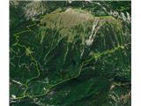 19 19
| (+9) |  | |
|
|
|
You must log in to post a comment:
If you do not yet have a username, you must first
register.