|
| benjamin71. 01. 2026 14:09:47 |
Šentanc icy, what kind of crampons? Maybe a photo? Thanks.
|
|
|
|
| benjamin71. 01. 2026 14:09:52 |
Šentanc icy, what kind of crampons? Maybe a photo? Thanks.
|
|
|
|
| Tomco18. 02. 2026 18:55:14 |
Looks great! Thanks for the report, nice to see after a longer “dry” period without reports from the high mountains (justifiably so).
| (+2) |  | |
|
|
|
|
| seba2322. 02. 2026 01:00:45 |
Hi.
Up to where is the road passable from Begunje to Planinica hut (turn to Roblekov dom)?
Is the hiking trail from 'Gostišče Draga' to Roblekov dom passable?
Are proper crampons needed or just mini spikes?
Thanks
|
|
|
|
| Tomco28. 02. 2026 18:01:12 |
EDIT: in the meantime I found out that the variant we did today is not the right but the left branch.
Then this other variant that we additionally tried is not the left branch but some more climbing-oriented route even more to the left. Although they told us on site that that is supposedly the left branch. 
Can someone help correct possible confusion based on the pictures? So that I don't mislead or spread disinformation with the publication.
Thanks!
| (+2) | | |
|
|
|
|
| turbo28. 02. 2026 19:35:42 |
Long ago I was often in the Y, usually left exit, then skiing down via Šentanc. I also went right, I think only once, I remember it was unpleasant for me, I don't know if because of bad conditions or exposure, but it's decades ago.
This is good to read => see attached photo: https://www2.arnes.si/~mcuder/vrh/veliki_vrh_b.html
Y Gully (IV-, above S5)
The gully splits below the summit and has two exits to the ridge (hence the name Y). The ski one is the left arm of the Y, but the right one has also been skied.
Similar to the Central gully to the cirque end and then right in the middle of the cirque end into the gully. A bit higher the gully widens, the narrower continuation opens a bit right of the plumb line. Higher the gully widens again. Straight above us is the summit rock step, left and right we notice two possible exits. The left one is not the most visible, since the exit itself to the ridge cannot be seen from here.
The right exit leads to a side ridge, along which we reach the main ridge at ridge elevation 2035m (a bit larger bump east of the main summit). This exit is less skiable because the side ridge is harder to ski.
The left exit is unclear from below, but higher it nicely opens a passage to the ridge. Several variants are even possible (at least two). The easiest is if we hold to the left side (always straight in the gully) and then under the summit rocks traverse to the right (good 10m below the ridge) and climb up onto the ridge.
| (+1) | | |
|
|
|
|
| garmont28. 02. 2026 19:48:52 |
For me personally the right branch is easier than the left one. There was once an 8mm rope up in the rock of the left branch that helped…
| (+1) | | |
|
|
|
|
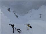
| parenzo28. 02. 2026 20:46:16 |
At the right one there is only one possibility. Get to the little ridge. At the left one, the exit possibilities are “unlimited”, or depending on conditions, or how it is “filled”, which significantly affects the difficulty.
On 16.02.2020 I posted this photo above the exit from the left branch.
Back then I just went straight.
 1 1
| (+1) | | |
|
|
|
|
| Hike0028. 02. 2026 21:37:39 |
Hi, on Friday I made the track on this "left" branch, only that this is not the left branch, but a route more to the left of it. Maybe someone knows the name of the route? For easier orientation I attach gps track and link to the video, I have fewer photos though. I think the link will be active only 3 days, because I don't have a premium account. 🙂
https://we.tl/t-61tO0p7CKr
 1 1
| (+1) | | |
|
|
|
|
| Tomco1. 03. 2026 09:40:17 |
Thanks for the answers. Yes, into this other one we then went on the tracks that Hike00 made the day before. At the place on my picture 6 instead of continuing right along the Y route, you branch off into the gully even more left and then this is no longer the Y route. At first it is relatively easy and filled, then from one overhang onwards you find yourself on very demanding rocky terrain.
No wonder we turned back. I have corrected my post and the comments under the pictures.
|
|
|
|
| Trobec5. 03. 2026 23:45:47 |
Hm... while reading the above discussion I myself for a moment wasn't 100% sure anymore if it really was the left branch back then (page 59)... or "left left" 
|
|
|
|
| Tomco6. 03. 2026 17:33:16 |
Since I have a fresh memory... 
From the pictures, back then (post on page 59) they were in the classic left branch, although in much more demanding conditions than current ones.
This "left left" ( ) is something completely different...
| (+1) | | |
|
|
|
|
| Trobec6. 03. 2026 21:00:19 |
Well, I'm finally reassured that it really was the left branch
Yes, conditions back then really weren't the easiest... on the repetition the next year it was significantly easier.
| (+1) | | |
|
|
|
|
| joža x27. 04. 2026 19:35:59 |
For May 1st, I'm tempted by Begunjščica, but does anyone know how much snow there is? Thanks
|
|
|
|
| Pero_2427. 04. 2026 20:45:29 |
I was there on Saturday, up via Prevala and Kalvarija, then down via Roblek dol, a couple of snow patches towards the top, completely unproblematic or you can bypass some. No need for crampons. Lp
| (+2) | | |
|
|
|
|
| joža x28. 04. 2026 07:31:43 |
| (+1) | | |
|
|
|
|
| joža x1. 05. 2026 21:20:22 |
Today was a wonderful day on Begunjščica, if we exclude the wind, which was particularly strong along the ridge from Draga via Kalvarija to the summit. Without anything special. Patches of snow are unobtrusive. Best regards.
 1 1
| (+2) | | |
|
|
|
You must log in to post a comment:
If you do not yet have a username, you must first
register.