Hike.uno
Hike.uno
Login
Login
Username:
Password:
Login
Not registered yet? Registration.
Forgot password?
      

Ojstrc (Hochobir 2139m) Austria

Print
geppo21. 06. 2008 18:47:44
21.6.2008

Today we descended to Austria via Pavličev saddle. The purpose of the path was to see Obir. Signs for HOCHOBIR are densely placed along the road and the path was easy to find. When the road starts steeply ascending towards EISENKAPPEL HUTTE, after a few km we arrive at the hut where toll should be collected. We figure it's supposed to be 5 euros (but no one at the hut even on return). At EISENKAPPEL hut there's a fairly large parking lot. In front of the hut the path to Obir starts right uphill and we immediately enter a nice spruce forest. After 30min the path opens and a wonderful view appears on KAMNIŠKO SAVINJSKE-KARAVANKE-DRAVA-OLŠEVO...

Path strewn with stones and scree - footwear you know what for such terrain! Along the path constant signs warning about features and sights (also in Slovenian). Otherwise suitable for hikers of all ages. Not demanding and quite busy - greetings in all languages. Hikers extremely friendly. Water along path sufficient, view surprises every moment. Botany in full bloom. After 1.5 hours to summit with wonderful view. Return same way and drive to lake seen from top. Continue via Koroška-Pliberk-Črna-Sleme to Savinjska. Very nice trip, recommend to everyone. Especially families with kids and hikers not into via ferratas and pegs.

path description

http://www.hribi.net/gora.asp?gorovjeid=11&id=560

Regards
Ojstrc (Hochobir 2139m) Austria Hut1
Ojstrc (Hochobir 2139m) Austria Start of the path2
Ojstrc (Hochobir 2139m) Austria Rocky and scree path3
Ojstrc (Hochobir 2139m) Austria View towards the summit4
Ojstrc (Hochobir 2139m) Austria Kamniško ...5
Ojstrc (Hochobir 2139m) Austria Murka6
Ojstrc (Hochobir 2139m) Austria I don't know...7
Ojstrc (Hochobir 2139m) Austria Water8
Ojstrc (Hochobir 2139m) Austria View back9
Ojstrc (Hochobir 2139m) Austria What is that...?10
Ojstrc (Hochobir 2139m) Austria Remains of the meteorological station - formerly the highest11
Ojstrc (Hochobir 2139m) Austria Crows show off and beg for food - they entertain with mischief12
Ojstrc (Hochobir 2139m) Austria Pole of electrical wiring to the meteorological station - once13
Ojstrc (Hochobir 2139m) Austria Clouds began to slightly cover Obir14
Ojstrc (Hochobir 2139m) Austria Down below they are already swimming at velk (water is still cold...)15
(+1)like
aljazek21. 06. 2008 19:20:34
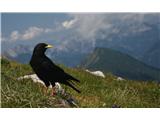
Here's another jackdaw from today's hike!
1
Karawanks2
(+1)like
izigov5. 10. 2009 22:04:09
Yesterday's hike.
Weather super with wind on top.
- from start - ŠAJDA pass Obir summit - 3 hours up and back 2 hours.
Regards from Carinthia
Summit of the pass - starting point1
Signpost at the starting point2
Near the starting point3
Kamniške and Savinjske alps in the sunlight4
Košuta5
6
View towards the summit7
Cross on the summit8
Summit9
A little below the summit10
View of the Julian Alps11
Kamniške - part 112
Kamniške - part 213
Towards Veliki Klek/Großglockner14
Obir summit once again15
even these enjoyed it16
path through the clearcut17
From the road back to the trail18
Path towards Kocmunov križ19
Kocmunov križ20
path21
path22
path23
path24
Valley towards Selam25
Farm under Šajda pass26
(+1)like
majdicst27. 06. 2010 17:34:54
This morning with my wife on the way back from Klopinjsko lake we went to Obir too. Started at Eisenkapplerhütte and to the top took one hour and quarter. Weather just right for this tour, not too hot, along the ridge just light breeze, on top occasionally a puff. Jackdaws are incredibly tame, as soon as you pull snack from backpack they surround you waiting for treat.
Lots of people, whole way down we met individuals and larger groups still ascending to top. At least half were Slovenes, also on parking lot lots of cars with Slovenian plates.
View of Obir from the path1
Just below the summit2
Just below the summit3
View towards Slovenian mountains4
View of the summit of Obir from the north5
Cows know no fear6
Ruins of Rainer hut7
(+1)like
JTrogar6. 07. 2010 13:04:42
We climbed Ojstrc on Sunday. Parked in front of Eisenkappler Hütte. Since our group had some with zero mileage we walked really slowly and enjoyed the nice nature and views. On top we took a long break, which would be longer if weather hadn't worsened so fast. On return we got heavy shower with hail, wind and thunder. Path turned into real torrent. But important that all ended safely. Because of that we drove back quite comically underdressed. Only missing was police stop. Would be hard to explain our look. Anyway such adventures on our paths we remember best in the end.
Nice regards from under nice Mozirska planina, Janez.
still resting1
morning scene2
3
Ojstrc is already visible4
I was there on Wednesday5
passing four-legged friends6
snapshot7
8
snapshot9
remains of mountain hut burned in 194410
windows still serve their purpose today11
our group12
snapshot13
summit14
15
16
17
even dry-stone walls are blooming18
(+1)like
alpin28. 12. 2010 08:08:04
Yesterday visited neighboring Ojstrc 2138m high hill above Železna Kapla. Snow conditions very pleasant, crust holding human weight, sprinkled with 10cm powder, towards top icy crust. Purpose was to fly from top but at 12m/s north wind the wings stayed in backpack.
1
2
3
4
5
6
7
8
9
10
11
12
(+1)like
sla28. 12. 2010 10:01:36
Eh yeah, in winter you carry gliders uphill :-)
Why didn't you invite me along?
like
alpin28. 12. 2010 19:31:09
On Thursday we plan to visit this mountain again. Space for 2.
like
sla29. 12. 2010 08:07:45
Alpin - wouldn't we rather go flying to Primorska on Thursday. If to mountains, then ski...

Solido - do you use them velik nasmeh
like
to36. 01. 2011 23:25:27
Does anyone know what the conditions are like on the path to Obir? Thanks for the reply and best regards!
like
JORDAN17. 01. 2011 08:10:47
Yesterday my friend and I started from Šajda saddle towards Obir. Path through forest in switchbacks to about 1500m no snow, further to about 1700m partly icy but no crampons needed. From Kacmunov cross onwards well trodden hard snow on path, so no crampons needed. To summit 3 hours. At top lots of hikers, nice views. Weather so warm we did ascent and descent in short sleeves, only at top put on a bit. On descent snow got crusty but didn't break on trodden path. Descent 1h20min.
like
Bbrina7. 03. 2011 20:27:44
We left the car at Kurnikov saddle... somewhere there. Then Eisenkappel Hutte and to the top of Obir massif, Ojstrc.
We had touring skis in the car but left them in the trunk, as it was visible that there was no snow far towards the summit. Snow starts above the hut, track is made but not "highway". Ojstrc basked in the sun today like all mountains far around. The views were, of course, magnificent. Even ravens enjoyed the day, of course they don't get cold dressed in black windstopper... wink At the summit and on the path down it was a bit windy.
smile
Einsiedlerkapelle hut1
Obir mountains with the highest peak-Ojstrc2
walls of the hut with rich history, at 2042 m3
view from the summit towards Drava valley4
KSA in the background5
in the background the north face of Košuta6
at the summit only choughs were for company...7
(+1)like
Tadej25. 03. 2011 07:23:29
Yesterday Rok and I ascended to Ojstrc, highest peak of Obir massif, from village Suha/Zauchen. For ascent used path through Kunetov graben, descent via adjacent path to Suha stream valley. Both paths to Eisenkappeler Hütte mostly dry except some snow patches. From hut onwards forest path fully icy, higher 5-40 cm snow, crusty in morning, sinking in places during day.

Regards, Rok and Tadej
Starting point.1
View of Ojstrc.2
Chapel at Počula saddle.3
Northern face of Košuta.4
Eisenkappeler Hütte.5
View of Kamnik-Savinja Alps.6
View towards the summit.7
View towards Drava valley.8
Path to Obir.9
Triglav.10
A bit below the summit.11
Cross on Ojstrc.12
View from the summit.13
Peca.14
On the descent the path led us past an abandoned mine.15
Mine cart.16
Black slug.17
Common liverwort.18
(+1)like
brencel29. 03. 2011 12:02:27


hello hikers
interested if anyone knows if there's still snow on road to Eisenkappel Hutte,
or is road clear
thanks and best regards

like
Tadej29. 03. 2011 12:29:33
Last week road was still closed. But nice path also from valley. http://www.hribi.net/izlet/suha___zauchen_ojstrc_hochobir_skozi_kunetov_graben/11/560/3141
(+1)like
brencel29. 03. 2011 14:03:10
Tadej,
thanks for reply and regards
like
PzS5. 04. 2011 14:31:36
On Sunday with a friend from the Šajda saddle. Snow/ice starts from Kacmunov cross, as we started a bit later, it was already melting. The path was fine, the only danger that day was the sun, both of us were a bit sunburned smile
1
2
3
4
5
6
7
8
9
10
(+1)like
klavdy630. 09. 2011 10:10:11
Yesterday from Kurnikov saddle to Obir. Just before the saddle a barrier where you have to pay 6 euros even if not driving to Eisenkappler Hütte. First part on asphalt road in thick morning fog, no views. From Obir pasture steeper forest path to hut. Continued to summit, above 1800m fog thinning, first views. At top beautiful view on Slovenian mountains whose peaks peeked from fog. On way back enjoyed nice warm weather and autumn colors. Whole tour with stops 6.5 hours. Best regards
First time we see the summit (on the right)1
A little before the summit2
View towards the Kamnik mountains3
4
Triglav5
On the way to the valley6
Eisenkappler Hütte7
View of Obir from afar8
Košuta9
Autumn colors10
(+1)like
geppo11. 12. 2011 20:33:58
After three years back to this scenic summit.

Colleagues chose longer variant from Šajda saddle (3hrs).
Fog greets us and we miss great view on Košuta ridge.
Path from saddle to Obir not as steep as it looks from parking.
As we ascend snow and frost appear. North wind cools us. Hope summit in sun that shows occasionally.
No one minds, as these weather changes surprising us are exciting.
Sometimes someone writes weather was "perfect". We had varied...
In 2.5 hours at top. Few pics, snack (some have multiple snackssmilesmile ) and down.
Home via Pavličev saddle. Officially closed from Austrian side with signs. We risk as no snow expected on road and hope no physical barrier. No traffic and successfully descend to Logarska.
Nice Sunday trip in good company..
Regards
Sedlo Šajda1
Košuta is hiding2
Snow and fog appear3
Strong wind along the ridge4
But they don't mind5
6
After two and a half hours SUMMIT7
And group photo8
He he, quick moves with snack :)))9
One more woman before descent10
Into the valley11
12
13
View towards Košuta14
Returning over Pavličev sedlo15
(+1)like
Janezs22. 12. 2011 18:47:53
22.12.2011 Today Romana and I started the hike at Sajda. Our goal was Obir. Here snow did not exceed 10 cm. Higher it increased with every elevation meter. At Kacmunov cross we put on gaiters. Snow cover already exceeded half a meter. The track was already made, in many places also completely drifted. Above forest line north wind was bothering us, accompanied us to the top. On top quick log entry and immediately turn back. Descent was much easier, halfway we meet a hiker on ascent. We speak a few words, then till the car we don't stop anymore. Lp.
Starting point at Sajda 1062m a.s.l.1
Cold sunny morning2
On the clearcut3
Above Kacmunov križ snow cover thick 70cm.4
Above forest line it is quite windblown5
Grandma is sleeping6
Hug for warmth at the top7
View towards Peč8
View of KSA9
In the background Kosutnikov turn10
During descent, something sweet11
(+3)like
Hribovc8822. 12. 2011 19:16:05
Wonderful pre-Christmas hike. Very nice photos, congratulations on the ascent wink
like
Page:123...789
You must log in to post a comment:
Username:
Password:
Login
If you do not yet have a username, you must first register.
         
Copyright © 2026 Hike.uno, Terms of use, Privacy and cookies