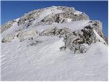
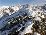
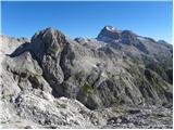
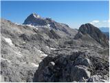
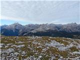
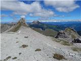
 | Planina Blato - Zadnji Vogel (snowy approach)
The mountain is located between Debeli vrh and the Zelnarice. From the summit there is a beautiful view of Kanjavec, Debeli vrh, the Vršaki, and ...
4 h 15 min |
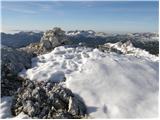
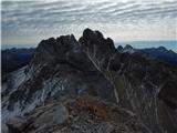
 | Planina Blato - Velika Zelnarica (Za Kopico)
Velika Zelnarica is a 2320 m high peak west of the Vrata saddle, which separates the Valley of the Triglav Lakes from the Za Kopico valley. A sma...
4 h 15 min |
 | Turkov rovt (Vrata) - Begunjski vrh (snowy approach)
Begunjski Vrh is a 2,461 m high mountain located in the heart of the highest peaks of the Julian Alps. From the summit, which has a registration ...
4 h 30 min |
 | Turkov rovt (Vrata) - Visoka Vrbanova špica (snowy approach)
Visoka Vrbanova špica is located at the far southwestern end of the ridge rising above the Kot and Vrata valleys, and higher up between the Kot a...
4 h 20 min |
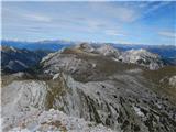
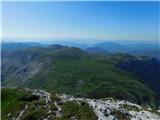
 | Planina Blato - Prvi Vogel
Prvi Vogel is a panoramic peak located above Planina v Lazu pasture and the Za Kopico valley. From the top, there is a nice view toward the Fužin...
3 h 50 min |
 | Planina Blato - Srednji Vogel
Srednji Vogel is an indistinct peak between the Za Kopico valley and Konjske Police, west of Debeli Vrh. From the top, there is a beautiful view ...
4 h |
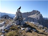 | Aljažev dom v Vratih - Gubno (above Kriška stena)
Gubno is a lesser-known peak above the Krnica valley. From its spacious summit there are fine views of the highest Julian Alps peaks, prominently...
4 h 40 min |
 | Dolina Krma - Vrh Snežne konte
Vrh Snežne konte is a 2,342-meter-high mountain located southeast of the more renowned Kredarica. From the summit, a beautiful view opens up towa...
4 h 45 min |
 | Planina Blato - Vrh Hribaric (via Planina v Lazu and through valley Dolina za Debelim vrhom)
Vrh Hribaric is a 2,388-meter-high mountain located between Vršaki, Kanjavec, Mišeljski Konec, Škednjovec, and Debeli Vrh. From the summit, marke...
5 h |
| Planina Blato - Vrh Hribaric (via Planina Krstenica and through valley Dolina za Debelim vrhom)
Vrh Hribaric is a 2,388-meter-high mountain located between Vršaki, Kanjavec, Mišeljski Konec, Škednjovec, and Debeli Vrh. From the summit, marke...
5 h 15 min |
 | Planina Blato - Vršaki (Vzhodni vrh) (via Planina v Lazu and through valley Dolina za Debelim vrhom)
The eastern peak of Vršaki (the first from Hribaric) is a 2,448-meter-high mountain situated between Kanjavec, Debeli Vrh, and Zadnji Vogel. From...
5 h |
| Planina Blato - Vršaki (Vzhodni vrh) (via Planina Krstenica and through valley Dolina za Debelim vrhom)
The eastern peak of Vršaki (the first from Hribaric) is a 2,448-meter-high mountain situated between Kanjavec, Debeli Vrh, and Zadnji Vogel. From...
5 h 15 min |
 | Planina Blato - Vršaki (Srednji vrh) (via Planina v Lazu and through valley Dolina za Debelim vrhom)
The middle peak of Vršaki is a less prominent summit located between the eastern and western Vršaki. From the top, a beautiful view opens up onto...
5 h 20 min |
 | Carbonin - Helltaler Schlechten
Helltaler Schlechten is a 2711-meter-high peak located in Fanes-Sennes-Prags Nature Park. No path leads to the summit, but due to its not overly ...
3 h 50 min |
 | Rifugio Ra Stua - Remeda Rossa / Rote Wand
Remeda Rossa (German: Rote Wand) is a 2605-meter-high pathless peak in the Dolomiti d'Ampezzo Nature Park. From the summit there is a superb view...
3 h 15 min |
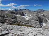
 | Rifugio Ra Stua - Piccola Croda Rossa / Kleine Gaisl
Piccola Croda Rossa (Kleine Gaisl) is a 2859-meter-high mountain on the border between the Dolomiti d'Ampezzo and Fanes-Sennes-Braies Nature Park...
4 h |
 | Rifugio Pederü - Roter Turm
Roter Turm is a 2553-meter-high pathless peak on the border between the Dolomiti d'Ampezzo and Fanes-Sennes-Braies Nature Parks. The summit is re...
4 h 5 min |
| Rifugio Pederü - Remeda Rossa / Rote Wand
Remeda Rossa (German: Rote Wand) is a 2605-meter-high pathless peak in the Dolomiti d'Ampezzo Nature Park. From the summit there is a superb view...
4 h |
| Rifugio Pederü - Piccola Croda Rossa / Kleine Gaisl
Piccola Croda Rossa (Kleine Gaisl) is a 2859-meter-high mountain on the border between the Dolomiti d'Ampezzo and Fanes-Sennes-Braies Nature Park...
4 h 45 min |
 | Lech da Sompunt - Ciampani
Ciampani is a 2,668-meter pathless peak in the Puez mountain group in the Italian Dolomites. From the summit, where a cairn stands, there is a ve...
3 h 50 min |
 | Lech da Sompunt - Muntejela de Puez (path 11)
Muntejela de Puez is a 2,666-meter-high peak located in the Puez-Odle Nature Park in the Italian Dolomites. From the summit there is a very nice ...
4 h 10 min |
| Lech da Sompunt - Muntejela de Puez (path 15)
Muntejela de Puez is a 2,666-meter-high peak located in the Puez-Odle Nature Park in the Italian Dolomites. From the summit there is a very nice ...
5 h |
| Colfosco - Muntejela de Puez
Muntejela de Puez is a 2,666-meter-high peak located in the Puez-Odle Nature Park in the Italian Dolomites. From the summit there is a very nice ...
3 h 45 min |
| End of road on Vogar - Prvi Vogel (via Griva)
Prvi Vogel is a panoramic peak located above Planina v Lazu pasture and the Za Kopico valley. From the top, there is a nice view toward the Fužin...
4 h 35 min |
| End of road on Vogar - Srednji Vogel (via Griva)
Srednji Vogel is an indistinct peak between the Za Kopico valley and Konjske Police, west of Debeli Vrh. From the top, there is a beautiful view ...
4 h 45 min |
 | Seetal - Kleiner Hochschwab
Kleiner Hochschwab is a 2,248-meter-high peak located near the slightly higher Hochschwab peak. From the summit, a beautiful view opens of the Ho...
4 h 55 min |
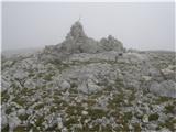 | Planina Blato - Debeli vrh (čez Planino Krstenico)
The peak is situated above the Planina v Lazu pasture. It offers a very beautiful view of Triglav, Kanjavec, and the other surrounding peaks....
4 h 25 min |