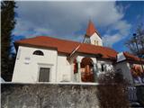
 | Bistrica pri Tržiču - Sveti Jurij above Tržič (on eastern road)
The Church of St. Jurij, built in the 15th century, stands on a small hill above Tržič or Bistrica pri Tržiču. Nearby Gutenberg Castle, to which ...
25 min |
 | End of road below Jelovec - Limberk
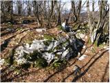
Limberk is a 687-meter-high peak located south of Grosuplje, more precisely above the village of Predole. From the summit, which has a logbook bo...
35 min |
 | Tone Čufar square (Jesenice) - Kalvarija above Jesenice (steep path)
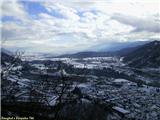
Kalvarija is a popular point or peak above the town of Jesenice, known either as a sort of short "pilgrimage" path for the faithful or as a desti...
35 min |
 | Jesenice (Straža) - Kozjek
Kozjek is a 766 m high, easily accessible ridge-like secondary peak of Jelenkamen, belonging to the southern Karawanks foothills; it is located a...
25 min |
 | Kočna - Žerjavec (Kavče) (steep north path)
Žerjavec (also Kavče) is a forested and partly rocky hill rising east above Kočna settlement (Poljane nad Jesenicami) at 805 m. It is mainly know...
25 min |
 | Kočna - Žerjavec (Kavče) (south path)
Žerjavec (also Kavče) is a forested and partly rocky hill rising east above Kočna settlement (Poljane nad Jesenicami) at 805 m. It is mainly know...
30 min |
 | Potoki - Gradišče nad Sotesko (Soteska)
Gradišče nad Sotesko (also Soteska) is a 724 m high hill located on the border between the settlements of Koroška Bela and Potoki, in the municip...
30 min |
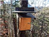
 | Kupljenik - Gradišče pod Babjim zobom
Gradišče pod Babjim zobom is an 824-meter-high, fairly panoramic peak located above the right bank of the Sava Bohinjka River. There is a summit ...
25 min |
 | Bistrica pri Tržiču - Gutenberk Castle (Hudi grad) (east path)
Gutenberk Castle (Hudi grad), also known as Stari Gutenberk or Altgutenberg in German, is among the oldest castles in Slovenia. It is first menti...
25 min |
 | PC Todraž - Sveti Urban (above Gorenja Dobrava)
The Church of St. Urban is located on a hill between Gorenja Dobrava and Todraž. From the summit, where there is a summit register box with a log...
25 min |
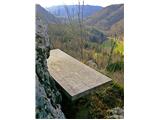
 | Podljubelj - Kršiše (eastern path)
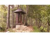
Kršiše is a hill above Podljubelj where, near the transmitters, there is a bench and a logbox with logbook....
22 min |
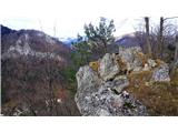
 | Brezovica - Markova glava (lookout cliff)
Markova glava is a hill in the municipality of Semič at 755 meters elevation, situated above Črmošnjiška dolina. In its immediate vicinity is a p...
30 min |
 | Škalnica - Veli vrh (above Škalnica) (Way of the Cross)
Veli Vrh is an indistinct forested summit located above Škalnica, near Pliševica. Just below the top is the final station of the Way of the Cross...
25 min |