 | Krajiška Kutinica - Humka (Moslavačka gora)
Humka is the highest peak of Moslavačka gora, a range located in the heart of Pannonian Croatia. Despite its relatively low elevation, Moslavačka...
50 min |
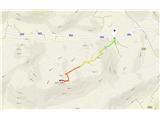
 | Radeče - Svinjski rt
Svinjski rt is a panoramic peak located north of Radeče. From the top a beautiful view opens towards the Sava River and Posavje. The logbox is lo...
45 min |
 | Konoba Mala Kapja - Kom
The second-highest peak on Korčula Island. A wonderful vantage point....
1 h |
 | Lovska koča Muljava - Veliki Petrovac (Petrova gora) (Roman path)
Veliki Petrovac is a 512-meter-high peak on Petrova gora....
50 min |
 | Lovska koča Muljava - Mali Petrovac (Petrova gora) (Roman path)
Mali Petrovac is a rather low hill located somewhere on the border between Banija and Kordun, as well as Pannonian Croatia and Gorski Kotar. The ...
1 h |
 | Gojače - Školj Svetega Pavla above Vrtovin (past trough)
Školj sv. Pavla is located on a panoramic hill above the village of Vrtovin, which lies west of Ajdovščina. From the church, near which the logbo...
1 h |
| Malovše - Školj Svetega Pavla above Vrtovin
Školj sv. Pavla is located on a panoramic hill above the village of Vrtovin, which lies west of Ajdovščina. From the church, near which the logbo...
1 h 5 min |
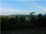 | Bistrica ob Sotli - Svete gore (E7 path from Bistrica ob Sotli)
Svete gore (527 m) is a hill in the Orlica range, located at the far eastern end of Posavsko hribovje. Its summit, with five church buildings, is...
50 min |
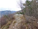 | Gradišče pri Vipavi - Plaz
Plaz or Vrh Plaza is a 528-meter-high peak above the Vipava Valley, more precisely between Vipava and Gradišče. From the summit, which has a summ...
40 min |
 | Tremerje - Vipota
Vipota is a 532-meter-high peak south of Celje above the left bank of the Savinja River. Approaches to the summit are possible from several direc...
1 h |
 | Zagrad - Vipota
Vipota is a 532-meter-high peak south of Celje above the left bank of the Savinja River. Approaches to the summit are possible from several direc...
1 h |
 | Naraplje - Church of St. Bolfenk (Jelovice)
The Church of St. Bolfenk is situated on a 537-meter-high hill above the settlement of Jelovice. From the top, a nice view opens up towards Haloz...
1 h |
| Stogovci (Vabča vas) - Church of St. Bolfenk (Jelovice)
The Church of St. Bolfenk is situated on a 537-meter-high hill above the settlement of Jelovice. From the top, a nice view opens up towards Haloz...
1 h |
 | Zagorica pri Dobrniču - Lisec (Liška gora)
Lisec is a 565-meter-high peak located north to northeast of Žužemberk and southwest of Dobrnič. On the summit stands a metal cross with an attac...
1 h |
 | Podčetrtek (sveti Lovrenc) - Zavetišče Šmarnica on Mala Rudnica (past castle Podčetrtek)
The Šmarnica shrine is located on Mala Rudnica within the Rudnica range, a smaller hill chain above Podčetrtek. From the shrine there opens a bea...
1 h 5 min |
| Podčetrtek (sveti Lovrenc) - Zavetišče Šmarnica on Mala Rudnica
The Šmarnica shrine is located on Mala Rudnica within the Rudnica range, a smaller hill chain above Podčetrtek. From the shrine there opens a bea...
1 h |
 | Za koridorjem - Sabotin (direct way)
Sabotin is a hill above Nova Gorica or, more precisely, above Solkan. Despite its modest height, it is an excellent viewpoint with views of the J...
1 h |
 | Tremerje - Veliki Slomnik
Veliki Slomnik is a peak located between Košnica pri Celju and Liboje. The summit has a logbook box, but due to the surrounding forest, there are...
1 h |
 | Pišece (Pri mlinu) - Velika Vagla
Velika Vagla is a 667-meter-high peak located in the Orlice mountain range, specifically along the marked trail from Pišece to Veliki Špiček....
1 h 5 min |