Hike.uno
Hike.uno
Login
Login
Username:
Password:
Login
Not registered yet? Registration.
Forgot password?
      

Boč

Print
bruny13. 12. 2012 21:28:06
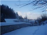
Yes, about Donačka gora more and that's excellently written by @ lajcicar, stankoju, Marx... and others. Current conditions are always relevant and if mežikanje something!? is added - why would it be boring. True that someone from Ljubljana, Koper, Idrija, Kranj... is mainly interested in Boč summit with viewpoint tower, mountain hut and surroundings, pasqueflower site...mežikanje ,,Skip,, my notes if not interesting to you..., otherwise maybe today on 13.12.2012 was already one of :wink: winter highlights. From Studenice with colleague Vinko along pronounced northern slopes hiking to Boč & Plešivec along quite momentary strong southwest wind to west to sturdy homesteads between peaks Hrastovec and Drenovec. Continuing along snowy paths east to Plešivec top, which was quite drifted... Hunters still supplying feeding sites with tractors as seen and their tracks suitable for faster progress. From top trudging through deep snow to forest road under ridge and then descent back to Studenice. Nice December Thursday, nothing else...Boč & Plešivec, 13.12.2012Best Bruno/bruny
1
(+13)like
skala12323. 12. 2012 21:01:25
Today on Boč. Path without features, some snow on the path which poses no problems. Strong wind at the top. Merry Christmas and Happy New Year to all female and male hikers and safe steps.
1
2
3
4
5
6
7
8
9
10
11
(+3)like
bruny31. 12. 2012 19:06:27
31.12.2012 to Boč area called Zadraga from starting point ,,Panzeršpere,, in Bela stream valley over Galka scree. Zadraga ridge is also border between administrative units Slovenska Bistrica and Šmarje pri Jelšah or municipalities Poljčane and Rogaška Slatina. Today visit to edge parts of Zadraga and need to go a bit deeper along ridge towards Bela stream, as it's interesting habitat for many animal and plant species including chamois and little logged.. On return extension to pasqueflower site on Boč and to top of Dreveniška gora, which due to pronounced ridge position towards west ideal for viewing last late afternoon sun moments of the year. Return along mountain path over Galke and quite some greetings with acquaintances still ascending to Boč. About mežikanje ,,Panzeršperah,, some other time... Happy 2013. Track:Boč/Zadraga, 31.12.2012 Best Bruno/bruny
...Before sunset on Dreveniška gora...1
...starting point „Panzeršpere“ in the valley of Bela stream...2
...sand pits...3
...and quarries mark this world...4
...in the first part on the road to Zg. Gabernik...5
...water object by the path...6
...and already on the path through Galka scrub...7
...also educational trail and the sun is „nice light„...8
...and the direction is known...9
...I have already written this and will do so again...10
...for masses of visitors  !?!  most beautiful path to Boč...11
...I am quite a strong Poljčane local patriot, but could quickly agree and rest area by the path...12
...already below the summit...13
...path junction...14
...before the viewpoint at Galkah but for views you must ,,go up here yourself !?!,,...15
...right the mountain path but I continued left - upwards along the summit ridge...16
..and already along the ridge...17
...and also the watershed...left Dravinja and right below the ridge Sotla...18
...wonderful and sunlit on Sv. Solvestra the day was...19
...shorter break for a better impression in 2012...20
...left Dreveniška gora and right !? kozjanski and zagorski peaks...21
...yes and already towards Zadrago and for the first time walking here...22
...really beautiful is this ridge which falls into the valley of Bela stream...23
...some things for the future should remain undiscovered...24
...and already on the way to the velikonočnice site...25
...ups... interesting warning !?...26
...this is already the better known part of Boč...27
...the church of Sv. Miklavž in 2012 will see no more sun...28
.. summit of Dreveniška gora is on the cover photo and already on return - velikonočnice site in ,,mix,, of winter, autumn and spring...29
...yes, no other option and back to the valley for a pleasant end to mountain biking and hiking activities in 2012... and Happy New Year 2013.30
(+3)like
pohodnik381. 01. 2013 08:48:58
Yesterday 31 December to Boč New Year's Eve hike. Won't waste words on the path as it's without features. At the top on the tower view wonderful just wind was quite wild. Descent along shady path to hut under Boč and over Baba to starting point.

Good luck, healthy, merry and many beautiful paths in 2013 I wishnasmeh

Tone

VIDEO-Boč-31-12-2012
1
All the way to KSA2
KSA3
4
5
6
7
Towards Donačka gora8
Towards Ptuj9
Podravje10
All the way to Pece11
Hut and view of the summit12
13
Stand of Velikonočnica14
Baba and view of Poljčane15
(+4)like
Hribovc882. 01. 2013 13:18:42
I'm wondering how many hours' walk it is from ŽP Poljčane to Boč?

Thanks
(+1)like
čebelar2. 01. 2013 13:49:47
depends how fast you walk?
otherwise about 2 hours.
(+1)like
Hribovc882. 01. 2013 14:01:17
Thanks.
(+1)like
bruny24. 01. 2013 20:25:44
24.01.2013 on Boč from Studenice and so it wasn't mežikanje ,,routine,, - first time to 612m high: Boč/Grilov hrib, which rises a bit above the mountain path from Boč or Plešivec towards Rogaška Slatina. Right decision in snowfall, drifts and thick fog, and approach to the top over the eastern ridge. Strong northeast wind building drifts, so quick descent and then continuing to the area between Sv. Marjeta and the homesteads Kleine and Valand, where winds on Boč and drifts have ,,their home,, and really it was ,,proper,,. Continuing descent over Formila and Golnik beekeeping hut back to Studenice. Solid hiking training, addition and novelty in the form of Grilov Hrib peak, a bit ,,sharper,, conditions... enough for snowy January Thursday afternoon.
Grilov hrib 612 m.a.s.l. peak on Boč...1
...Grilov hrib taken on descent from Plešivec...2
...along the eastern ridge today to the summit...3
...colleague Vinko and ,,nice breeze was blowing,,...4
...on the snowy path towards Gavez farmstead and hunters' lodge LD Rogaška Slatina...5
...St. Marjeta and Kostrivnica part of Boč for return...6
...slit for coins and we put in some for luck and safe paths on Boč...7
...below Kleine farmstead in strong northeaster, snowdrifts and snowfall back to valley for more substantial hiking loop on Boč...Lp8
(+5)like
bruny8. 02. 2013 19:50:47
08.02.2013 a bit more concretely on Boč and first time to the top TURK height 555m, located between Vrhovski homestead and Sv. Ana quite far east. To the top over Rudeka and Šlog along the bed of Veliki potok on the north side of Velika kopa. Terrain snowy, partly icy and quite some paths needed trudging. Summit not really outstanding and not rich in height but no regret with solid hiking training that I climbed it. Ascent and descent done along southern ridge.
Track:Boč/Turk,08.02.2013 Best
Turk 555m a.s.l.1
2
...Dedni vrh...3
4
...Veliki potok...5
6
7
8
...new cross below Turk...9
...hunting blind below the northern part of Turk...10
...on the spot I decided for the ascent along the southern ridge, which was more suitable and already ascending...11
...and this is the Turk summit...12
...and also the old cross on the southern part of Turk right by the Stoperška mountain path...13
...and also view of Stoperški Resenik where I have already been and today's 'crowded' Donačka gora...14
...and already on the return through 'Rudeko' below the northern part of Velika kope...15
...and also through 'Šlog' where wading was necessary...16
...mouflons blocked my path here...17
...and the direction is known...to the flat Ravnocerje along the gentle snow whiteness...18
19
...and already on the forest road under Plešivec...20
...hunter's hide by the road under Plešivec...21
...and already between Gavez and the Formilo clearing...Yes, today I would be ,,IN,, on Donačka gora or at the tower on Boč but also something!? at first glance ,,IN,, can also be the right one. Together 27 kilometers / and over a thousand elevation gain 22
(+5)like
bruny17. 02. 2013 22:40:38
17.02.2013 afternoon on Boč and first time to GRILOVA chapel at height 534m under 612m high Grilov hrib still quite high on Rogaška part of Boč; a partly circular path led me. Junction or in immediate vicinity of numerous paths from Rogaška Slatina to Boč and interesting natural landmark in connection with hill above it. Hiking, I set out from Studenice and in normal conditions easy hiking path, but in winter conditions ideal for training and of course new insights. Rogaška part of Boč I know poorly and right opportunity for ,,probing,, terrains somewhere under western part of Plešivec on mežikanje sunny side. Snow piled up really huge and I don't remember ever being in similar heights and still many drifts which are staple this winter. Paths snowy, partly foggy, temperature around zero and no wind.
Impressions:Boč/Grilova kapela,17.02.2013 Best
Gril's chapel 534 m.a.s.l. - Rogaška part of Boč1
(+2)like
bruny20. 02. 2013 23:04:40
20.02.2013 after...72 hours hiking return from Poljčane or rather starting point Studenice under Grilov hrib with the desire to mežikanje finally descend via Boč to Rogaška Slatina. Of course my colleague and I extended via Cerovec under Boč to Rogaška Slatina and continued in the direction along E7 to Brestovec above Rogaška Slatina. Speed today was not the first plan but mainly getting to know new terrains and memorizing the trail and natural landmarks for eventual return in longer presumably circular combinations to mežikanje sunny side of Boč. Afternoon activity in snowy landscape, light snowfall and new insights was the right thing. A centimeter of fresh snow enabled safer step on partially icy paths higher on Boč.

Trail:Boč/Rg. Slatina, 20.02.2013
Impressions:Boč/Rg. Slatina, 20.02.2013Best
1
...Cerovec below Boč.2
(+5)like
bruny27. 02. 2013 20:49:18
Night and morning light snowfall was a wonderful backdrop that already allowed added value when planning today's hiking activity. Mists played their game in the morning and at times more or less unveiled Boč. Already from the valley it was visible and consequently foreseeable that the 978-meter peak above the Dravinja river valley could be particularly mysterious and beautiful in its summit meters today... and no wonder, the decision quickly fell - ascent to the top and then addition of a combination for a thorough partially circular conclusion. The old-good starting point Studenice is always ready and in this snow-rich and consequently water-rich even more ready starting point. After two rather dry years, the springs of the Warm Studenice stream have really come alive in all their grandeur and it's really a special gift these days to watch the somehow mystical "gurgling" of water that has been emerging here for centuries, we people with our transience can only be joyful observers of nature's play and the power of its natural processes...

Ascent as always interesting and in the summit part the predictions came true. Mist dressed Boč in its own kind of web, one, two, three centimeters and no more... of fresh snow but special gentleness for really light and joyful step. Towards the top snow was still pleasantly and lightly falling and gave the mists an additional - I'd say somewhat soft touch. Tracks of a military vehicle from the morning hours and my footsteps in the silence of whiteness were the only thing that disturbed this world just below the thousand-meter mark. It was enough to the TV tower for pleasant diversification of the day on top of Boč and already quite close was the next turn - when darkness would overcome the gentle misty daylight in the penultimate day of February. Descent to Formile clearing and continuation towards the hikers' hut on Boč... where "kostrivniške" mists joyfully chased and here and there a snowflake for playing with the last colors of daylight. Continuation... descent to the valley and extension to Studenice... and thorough reflection on the grandeur.... of space and transience... of time. Lp Bruno/bruny

Placement in space & time:Boč/TV tower, 27.02.2013

Today without comment...Photos say more....1
2
3
4
5
6
7
8
9
10
11
12
(+4)like
vukovivek2. 03. 2013 13:38:51
The day before yesterday I headed to the Styrian hill Boč. Weather wasn't the best but still I took the path under my feet. On the way I didn't meet any hiker which usually isn't the case but it happens too.
Hut on Boč1
Start of the path2
Zlatorog's chamois pride transversal3
From Baba, view on Poljčane4
Snow in the lower part of the path 15-25 cm5
Church of St. Miklavž opposite the hut on Boč6
Mountain hut on Boč7
Second part of the path to the top8
On the second part of the path there is more snow 25-50 cm9
And here I am already at the viewpoint tower and the goal10
Viewpoint tower in fog11
TV transmitter Plešivc12
(+4)like
bruny2. 03. 2013 21:08:28
You somewhat mežikanje ,,missed it,, - Boč is a mountain and not a hill. But it's true, in the wider Boč area two peaks bear the name hill and that's Grilov - presented a few posts above and Cerov hill, which will in the future mežikanje presumably be presented too. Definitely nice tour and interesting photos...And another view of Boč in a more demanding tour - colleagues from the running forum...Maribor - Boč
like
jax3. 03. 2013 15:12:00
You somewhat ,,missed it,, - Boč is a mountain and not a hill.

Oh come on please ... ha ha ha ha ha ha ha.
like
vukovivek4. 03. 2013 18:52:07
so what if I missed it it's not 1000m asl
(+1)like
Daaam5. 03. 2013 07:35:04
Boč is a mountain? ...come on please..eek
like
jprim5. 03. 2013 07:53:49
If Mount Oljka can be, why not BOČ too?mežikanje
(+1)like
jprim5. 03. 2013 08:03:34
Well, a bit seriously ... elevations over 1500 m asl are mountains, so Boč really isn't.
LP!
like
tinky5. 03. 2013 09:16:39
Šmarna MOUNTAIN 669 m asl '''
1
like
Page:123...678910...353637
You must log in to post a comment:
Username:
Password:
Login
If you do not yet have a username, you must first register.
         
Copyright © 2026 Hike.uno, Terms of use, Privacy and cookies