|
| andrejjerina3. 11. 2009 17:20:38 |
Well, when I was up there was no logbox under the cross, no stamp either, so no name. All the info Fleksarca lists I found on the net too, thanks. Today I got info that it could really be Koroška Kepa. Heinz, it could be another mountain or peak, though close to Kepa. You know Belščice ridge has several peaks with different names but just a ridge, right? LP Andrej
|
|
|
|
| triglavski3. 11. 2009 17:41:17 |
In Austria I noticed many places besides summit cross another cross on ridge just below summit. Examples Polinik, Ojstrnik and Kepa. These crosses usually placed visible from valley village, each has purpose.
 1 1
|
|
|
|
| heinz3. 11. 2009 18:48:43 |
No. That's it. I agree, because if they put e.g. 10 crosses on Stol, would you then say you've conquered so many 2000ers at once, or what? (Actually there's also a sign or cross there, standing a few m below the summit.., and many other places..)
Kepa is just Kepa and can't be something else that you "supposedly" don't find on any map.
Maybe it's just a sign older than "that big one". Actually Kepa is an Austrian mountain and it would be logical that they placed their sign at the end-summit (for them) of a more demanding path..
For collecting summits or stamps you'll have to try harder.. No hard feelings, good luck!
|
|
|
|
| ben3. 11. 2009 19:29:11 |
I agree with Triglavski, namely another such example is Storžek. The summit is entirely in Austria and from Belska Kočna the cross is excellently visible, but when you climb up it's on the neighboring lower summit.
lp B
|
|
|
|
| Gorazd G3. 11. 2009 20:10:11 |
However you turn it; with crosses there's a cross 
For determining and exploring summits we know other ways too: say TTN - basic topographic map.
And one more. If I remember right, I read somewhere that they moved the cross from Stol summit a bit lower for safety. Right at the top it's steeply cut off. Elsewhere it's true that it's placed where it's well visible from the valley - even if on the shoulder and not exactly at the summit.
|
|
|
|
| pimento25. 01. 2010 14:18:42 |
Has anyone been around Kepa in the last few days or knows what the current conditions are like?
|
|
|
|
| janav25. 01. 2010 15:40:22 |
Heinz, please respect your homeland!!! Kepa is as Austrian as it is Slovenian!!!!
|
|
|
|
| heinz26. 01. 2010 07:39:30 |
Right away when you reach the summit along the SW ridge from Belca, you hit a border stone and larger sign that warns (informs) you where you are. Everything else is in Austria.
Of course a bit of Kepa is Slovenian too.
If you want it to be "as Slovenian as Austrian", you'll have to try and move the markers, then also ensure they fix it on all world maps.
Respecting facts doesn't mean you don't respect your homeland..
Save some exclamation mark for us too!
 1 1
|
|
|
|
| Mate0720. 05. 2010 19:58:04 |
What are the conditions like on Kepa?
|
|
|
|
| legenda22. 05. 2010 12:49:00 |
On Monday I'm setting off from Dovje via Planina Dovške Rožce to Kepa. Interested in how much walking from Dovške Rožce to Kepa and what current conditions on that path.
Heinz, can you help?
lp
|
|
|
|
| Mate0723. 05. 2010 17:21:10 |
The path to Kepa has two safety cables. About 15 minutes before the summit the terrain is very crumbly and very dangerous for slipping, at the time I was there I just wished it was a via ferrata.
Video:
 1 1
|
|
|
|
| legenda25. 05. 2010 09:43:05 |
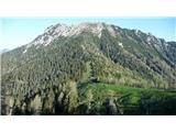
On Monday 24.5.2010 we were on Kepa. We start in Ravne nad Dovjem. To the Planina Dovške Rožce along the road, then slight descent to Sedlo Mlinca, onwards past water trough where path from Erjavčev rovta direction joins, then uphill through scree and across scree under Plevelniki (carpets of blooming edelweiss), then casually over summit of solitary Gubno, descent and ascent over perfectly secured notch, onwards under walls of Dovška Mala Kepa to junction of path from Austrian side, last meters to Kepa summit on Austrian side which is completely dry.
Conditions on path pleasant. Apart from two small snow patches, path completely dry, snow soft, fixed protections in good condition. On Austrian side a bit more snow, but I judge access not problematic as there were quite a few Austrians on Kepa summit even in sneakers.
From start to Kepa summit we walked 3h 45min. Returned same way.
 1 1 2 2 3 3 4 4 5 5 6 6 7 7 8 8 9 9 10 10 11 11 12 12 13 13 14 14
|
|
|
|
| legenda25. 05. 2010 10:02:41 |
Sorry. All image descriptions are shifted one image forward.
|
|
|
|
| Mate0725. 05. 2010 12:27:27 |
This path seems safer to me than the one from Belca.
|
|
|
|
| aljoša124. 06. 2010 10:07:14 |
Tomorrow we'd go to Kepa via planina Dovške Rožce. Just wondering how far by car and if the planina is open yet?
|
|
|
|
| tadeya24. 06. 2010 11:05:37 |
Yesterday we were at planina Dovška rožca and then on to Dovški babi, owner was already there. By car to first barrier, which is of course closed. Road still pretty good, but towards end there's quite a big pothole to watch out for if you want to drive further.
|
|
|
|
| aljoša124. 06. 2010 14:29:37 |
How high is this barrier?
|
|
|
You must log in to post a comment:
If you do not yet have a username, you must first
register.