|
| aljoša124. 06. 2010 15:38:33 |
I expressed myself a bit wrong, how long is the hike to Dovške rožce from that barrier?
|
|
|
|
| Tadej24. 06. 2010 15:51:19 |
|
|
|
|
| heinz21. 07. 2010 20:05:32 |
Today: everything at its best. No peculiarities.
Recommended. At the top mostly Austrians, three Slovenians.
Along the path from Belca barrier towards Jepca chanterelles are growing.
Up top warm, quite hot already.
Regards h!!
|
|
|
|
| alyas4. 10. 2010 19:41:28 |
Sunday conditions - on Kepa, along the forest road above Belca village:
Road drivable OK, no problems to the barrier, even at the saddle below bivouac some "normal cars" parked (not 4x4s).
Otherwise up to cca 1.700 m very dense low cloud, above that border surprising clarity. Views - only on high peaks, in Kranj-(Sava) and Austrian (Drava) valleys "gray - white sea".
|
|
|
|
| dj1229. 10. 2010 17:48:11 |
LP - has anyone gone to Kepa these days after snowfall? Maybe what are the conditions like?
|
|
|
|
| nata2415. 04. 2011 08:41:28 |
Has anyone been on Kepa recently, haven't seen anywhere...
|
|
|
|
| Gorski lovec15. 04. 2011 20:28:30 |
i wanted last time to go but ...lol
|
|
|
|
| sanabor16. 04. 2011 08:38:56 |
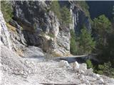
From Belca to Kepa I went on April 6. Road
after about 1.5 km impassable,
so have to go on foot. Road full of
stones and some larger rocks. I hiked
to Jepca saddle. Didn't go further because
still quite a lot of snow.
 1 1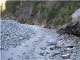 2 2
|
|
|
|
| ljubitelj gora16. 04. 2011 12:53:38 |
Those who will hike from Belca to Kepa park car a bit off main road, at some bend, cca 100-200-300 meters from main road, the gorge itself, tunnel, waterfalls by road, incredibly beautiful.
|
|
|
|
| nata241. 05. 2011 18:52:21 |
Today my colleague and I were on Kepa from Dovje. A bit of fog and some fresh white snow, which didn't pose any major problems, except that we first mistakenly got to Gubno  The tracks in the snow led there anyway. The path to Kepa goes over a larger snow patch and we didn't notice it, and no one has been walking there the last few days. At the top though, as ordered, sun. The tracks in the snow led there anyway. The path to Kepa goes over a larger snow patch and we didn't notice it, and no one has been walking there the last few days. At the top though, as ordered, sun.
 1 1
|
|
|
|
| Gorski lovec1. 05. 2011 19:28:14 |
Hehe, cool, Gubno is also over 2k
|
|
|
|
| Zalas1. 05. 2011 21:14:24 |
|
|
|
|
| rb018. 05. 2011 20:10:38 |
some pics from yesterday (Dovje-kepa):
|
|
|
|
| Parkeljc10. 05. 2011 16:35:01 |
Today started with colleague from below the barrier, first on road, then shortcuts and again road, a bit below planina Dovška Rožca the path branches left, to Kepa we go whole way on path, which has only two small snow patches we cross without problem. Only somewhat more demanding ridge crossing is between Dovška Mala Kepa and Kepa, as it's very narrow and crumbly, path snowy.
At top occasionally blew a bit too much, so we soon head back same way, just climb to Gubno in between. Protections in perfect condition and where needed. By the way, on meadow-pasture with sign "beware, vicious bull" a coal-black snake (adder???) rushes after us, but we know who was faster . Probably didn't like me wanting to photo it closer
 1 1 2 2 3 3 4 4 5 5 6 6 7 7 8 8 9 9 10 10 11 11 12 12 13 13") 14 14 15 15 16 16 17 17 18 18 19 19 20 20 21 21 22 22 23 23 24 24 25 25 26 26 27 27 28 28 29 29 30 30
|
|
|
|
| Gorski lovec10. 05. 2011 21:12:55 |
nice pics, nice tour;
those are adders
|
|
|
|
| ljubitelj gora3. 09. 2011 23:54:33 |
8 pics, I went that shortcut 2-3 years ago.
|
|
|
You must log in to post a comment:
If you do not yet have a username, you must first
register.