|
| Janezs14. 10. 2013 21:20:50 |
Yesterday on Košutica, a bit of work.
| (+2) |  | |
|
|
|
|
| Domch6. 11. 2013 12:47:07 |
For Reformation Day up on Ljubeljska Baba aka Košutica. Up from Ljubelj past hut on Ljubelj then ridge to summit, descent to Planina Korošica and road back to Ljubelj. Nice hike, but dense fog from Koča na Ljubelju on and wet, muddy, slippery terrain. No views. Will return to Košutica and extend at least to Hajnževo sedlo. Quite some people, all hoped in vain fog would lift. Hut on Planina Korošica closed, Kofce open. Today probably white up top.
| (+1) | | |
|
|
|
|
| katty23. 05. 2014 17:02:38 |
Hi.
Does anyone maybe have some info about Košutica and the prevailing conditions? It's one of the options for Sunday  . .
Thanks and best
|
|
|
|
| JUREE24. 05. 2014 14:31:48 |
Hi, Košutica is almost dry, there is still some snow on the saddle but nothing harder, so go courageously
|
|
|
|
| onlyx24. 05. 2014 22:08:20 |
Was today in clear and windy weather on Košutica and as the predecessor said, the path is mostly dry, except a bit below the top you cross a small snow patch, which basically doesn't make problems. If you go past the hut at Ljubelj, expect muddy and slippery path through the forest, plus fallen trees disturb, which are most likely consequence of the last windy weather. Maybe that's the most annoying part of the whole path, especially because the path due to lee terrain doesn't dry even during the day and caution is needed also on descent. Otherwise boldly on, views from the top are fantastic. Good luck!
|
|
|
|
| Potohodnik26. 05. 2014 20:29:54 |
On Sunday Košutica was on the schedule. We headed to Hanjževo sedlo and then along the unmarked path to Košutica. From the saddle onwards after 50m you're already climbing depending on height (if shorter, climb I., if taller, walk; no section except right below the top is secured). Rocks are loose, so it's wise to be very careful with rocks above us (fortunately no such fear on the ridge as on Hanjževo sedlo - Košutica) and that we don't dislodge rocks and holds/footholds don't break. Since snow is melting, ground is wet and slippage can happen. This is especially important on the summit ridge of Košutica, which is >>awesome<< exposed and poorly secured; towards the top of Košutica we climb unsecured I.-II. Two passages are very narrow (narrowest is 0.5m wide (barely)) and on both there are drops so no hand support. Where there are cables, no big problem. Easy to follow the little paths, as well-trodden. No snow on this path anymore. Prepared descent to the other side, where almost no snow left either. A little still on that path, but nothing special, doable without winter gear.
| (+3) | | |
|
|
|
|
| sirt15. 06. 2014 17:49:10 |
Ljubelj is one! No old or new. By your logic even Karavanke would be old, since they drilled new ones below.
|
|
|
|
| viharnik5. 06. 2014 18:08:58 |
Stari Ljubelj was known already in Antiquity during the Roman Empire. Later the area came under Habsburg rule all the way to Trieste. In 1573 Carniolan and Carinthian nobles built the road over the pass, two hundred years later they erected on top a border obelisk of two pyramids for Charles VI. Even now locals call the old passage to Carinthia Stari Ljubelj, where in modern times oldtimer races took place too. In short, here we have two different historically separated border passes, the one with Karavanke is just a tunnel and the Karavanke mountains, so don't mix pears with apples . .
| (+5) | | |
|
|
|
|
| sirt15. 06. 2014 18:33:45 |
You mix pears and apples! Ljubelj pass is one thing, Ljubelj tunnel another.
Even natives from Šentanska valley distinguish that.
Border passes are both old, since they don't exist anymore.
|
|
|
|
| viharnik5. 06. 2014 19:36:20 |
We all know the difference between a tunnel and a pass. Regarding history, the old pass at Ljubelj will still be known only as Stari Ljubelj. Even the Koča na mejnem sedlu is named after Stari Ljubelj.
But now you will write a new naming history of Slovenian geography, which was created already in the time of Primož Trubar from 1550 with abecednik and catechism.
| (+7) | | |
|
|
|
|
| slamca5. 06. 2014 21:19:35 |
| (+3) | | |
|
|
|
|
| Bandzo21. 06. 2014 15:22:56 |
I wanted to do a quick morning circular tour where you also conquer some elevation. And so Košutica offered itself as the ideal tour. Start at Vranček, then along the main road to the concentration camp, where I left the road and continued on the old path directly to the start of the Hunter's path. I followed this path to the top and enjoyed it. When I reached the top, I took a short breather, then headed towards Hajnževo sedlo down the Western path to Košuta. Here I'd emphasize that some caution is needed so we don't dislodge stones or slip ourselves, as there's quite some gravel on the path. Short chat with hikers who were also going to Košutica and whom I met on the way, then I was 1,2,3 at Hajnževo sedlo. Here I continued towards Korošica, where you simply forget time. Wonderful pasture. Nothing else to add. When I gathered enough positive energy to beneficially influence my closest ones too, I returned via the marked path past the hut back to Vranček. Super circular path and super energy in these parts. Even the cows are laughing 
| (+2) | | |
|
|
|
|
| Domch29. 06. 2014 15:23:26 |
Yesterday I went along the border guards' paths to Baba. Circular tour: Vranček-Planina Korošica-Hajnževo sedlo-Baba-Koča na Ljubelju-Prelaz Ljubelj-Vranček. Lots of visitors at Korošica, one group went climbing to the foggy Veliki vrh, but I turned left uphill along the ridge to Baba at Hajnževo sedlo. The path has a red dot according to Austrian markings, meaning not difficult, which of course is not true. The path is not marked but well traceable. First you climb a steep path full of pebbles and scree to the ridge, then the real thing starts. First you cross a narrow ridge about 2 meters long and with the help of a wire rope climb to the top of the rock, then cross the ridge on a narrow path, needing quite a lot of caution because the path is full of scree. Difficulty is in the range of the path to Veliki Rogatec. Once over the ridge there are no more major difficulties, as at the end when crossing from one summit to another there's a wire rope. Descending this path would require even more caution, but it's doable. I myself descended further all along the border to Koča na Ljubelju, where the hut opening was. The path itself is muddy in places, very overgrown, has some fallen trees, damaged wooden steps and the place where a landslide took the path is not yet repaired, but you can get past. I'd rather recommend descent via the hunter's path.
 1 1 2 2 3 3 4 4 5 5 6 6 7 7 8 8 9 9 10 10 11 11 12 12 13 13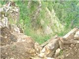 14 14 15 15 16 16
| (+2) | | |
|
|
|
|
| Andy197829. 06. 2014 16:47:09 |
I'd add this: on 7.6 the path to/from Koča na Ljubelju to Ljubeljska Baba was officially closed (I noticed the sign only at the end of the path at Ljubelj, don't know if it's still there). It was possible to pass, but the tricky part in picture 13 I see is not repaired yet. Careful steps.
 1 1
| (+1) | | |
|
|
|
|
| Laščan29. 06. 2014 20:58:25 |
Today we returned from Košutica to Koča na Ljubelju on this path. The part of the path (picture 13) is even more torn off and there are no more wooden parts, probably they came off. Continuation of the path through the forest on the Austrian side is very muddy, quite a few fallen trees across the trail. I think this path is not maintained at all.
|
|
|
You must log in to post a comment:
If you do not yet have a username, you must first
register.