|
| eskubik2. 07. 2010 11:40:21 |
The snow patches are soft and easy to cross, although they generally lack a safe runout and using an ice axe would be sensible/necessary...
|
|
|
|
| vampek2. 07. 2010 11:50:44 |
thanks eskubik,
then it would probably be smarter to go to Brana instead... 
|
|
|
|
| lucky2. 07. 2010 17:02:17 |
The road to Jermanca is in good condition.
Best regards.
|
|
|
|
| unibok5. 07. 2010 14:52:59 |
Yesterday my colleague and I visited Planjava. Conditions are super, no snow to the hut at Kamniško sedlo, and to the top of Planjava you only need to cross two about 10m long snow patches, which aren't overly dangerous. Winter gear not necessary.
Best regards. Boštjan.
|
|
|
|
| MarkoS5. 07. 2010 18:32:35 |
Esubik: if you don't know the conditions don't talk nonsense. Even if you mean well. We were up yesterday and as Unibok wrote from Kamniško sedlo only two small unexposed snow patches to cross. Winter gear really not needed there.
After your comment that creates panic, I still called the hut. Luckily, if someone read only your comment, we wouldn't have gone up yesterday.
|
|
|
|
| eskubik6. 07. 2010 13:31:13 |
To everyone who didn't go to Planjava because of my comment, I apologize, although I stand by what I wrote...
@MarkoS: If those snow patches, where you'll gain such speed sliding on your ass that rocks won't stop you anymore, seem unexposed to you, I apologize to you personally too, because I disagree with you.
But someone once wrote that no one has died yet because they carried an ice axe...
|
|
|
|
| zipo31. 07. 2010 21:43:13 |
Planjava is one of my possible tomorrow's destinations and I'm interested if I'll encounter any snow on the path?
|
|
|
|
| zipo31. 07. 2010 21:43:33 |
Planjava (from Kamniško sedlo) is one of my possible tomorrow's destinations and I'm interested if I'll encounter any snow on the path?
|
|
|
|
| maucec401. 08. 2010 18:42:27 |
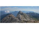
Today there were probably a record number of hikers on KS. That's why our chosen path to Planjava via Srebrno sedlo was very welcome, as we met only a few, but on every peak by Repov kot you could spot some mountaineer. Maybe someone recognizes themselves from the attached pics? Weather was really wonderful today, right?
|
|
|
|
| alpin2. 08. 2010 22:00:21 |
Yesterday we paragliders went to Planjava. At 5-20h from Jermanca past the saddle and then to the top. Wonderful panorama of our mountains, vegetation and animals recharged our batteries for daily life again. On the way we met "Trogarja" who fresh jumped a bit higher Sukavnik.
At the top strong gusts from Logarska were blowing, so we had to carry our "gliders" 100m lower but even there neither direction nor wind strength suited us. With colleagues' help I took off after some time, so colleagues ran out of time for safe takeoff and had to descend through Srebrno sedlo.
Filmed Zeleniške špice.
L.P.
|
|
|
|
| alpin2. 08. 2010 22:25:21 |
|
|
|
|
| aljazek11. 08. 2010 19:34:00 |
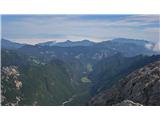
I felt like a short walk and invited a friend on a tour: Logarska dolina-Okrešelj-Kamniško sedlo-Planjava-Lučka Baba-Škarje-Grlo-Logarska dolina. This time I won't list times 
We walked the path all the way to Škarje without problems. Since we didn't feel like going past Klemenče jama, we chose the path over Grlo. It starts with a few short scree slopes, grass has overgrown the once-marked path well, stones are scattered on most steps, no marks or they've faded to unrecognizability. I have plenty of stamina, so I walked ahead searching nice natural passages. Sometimes I climbed even a III because I strayed from the path. On descent you sometimes see the outline of a trail, on ascent you really see nothing. Part runs under extremely crumbly wall known for rockfalls. When I felt some snake might hide under grass/raspberries/shrubs, I clapped a bit more. In short, trail goes through wonderful pristine Nature, almost no human traces,... Path is dangerous for inexperienced hikers due to piled stones, sometimes very demanding for orientation, small mistake leads to fun easy scramble, safety gear counted on fingers of one hand.
Well, I enjoyed it, no crowd either 
high quality photo version
 1 1
|
|
|
|
| lynx11. 08. 2010 21:27:13 |
Great tour, but I like the approach to difficulties even more.
|
|
|
|
| aljazek12. 08. 2010 08:55:07 |
Yeah, that last part through Grlo was my favorite.
|
|
|
|
| Griha12. 08. 2010 10:42:58 |
Aljazek, we two followed you yesterday on the path through Grlo. Quite nasty searching for passages, and crumbly climbing section in Grlo...not very pleasant. Did you find a passage directly to the parking under Rinka? We two reached the road a bit lower (at farm tourism).
|
|
|
|
| aljazek12. 08. 2010 11:17:30 |
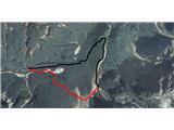
From afar I saw some trail towards the parking lot, but at the bottom of Grlo I couldn't find its start (buddy was tired, so we didn't search long in that strong sun). We came out at some hut with a fence, then along a nice forest path (it says: Path to Rinka waterfall or similar) to the parking lot.
PS: glad you two arrived safely at the bottom, hope we left some traces too for easier searching
On the picture I marked our path in black and the red path I saw from afar and how I assume it went:
 1 1
|
|
|
|
| peter skala13. 08. 2010 14:59:02 |
Aljažek, regarding your times you made the right decision, they fit more into the "extremes" category. Or clearly write that "normal" hikers multiply the time by two, or you might kill someone if a "normal" hiker follows your times.
|
|
|
|
| aljazek13. 08. 2010 23:19:32 |
I didn't imagine there would be such a problem with times. Next time I'll skip them and rather add some more photos
 1 1
|
|
|
|
| peter skala14. 08. 2010 10:39:23 |
Nothing else but you're fast, really fast.
|
|
|
|
| GričarA16. 08. 2010 09:21:47 |
I'm interested which path is the safest to Planjava, and if it is more demanding than the one to Ojstrica which goes first over Little Ojstrica.
|
|
|
You must log in to post a comment:
If you do not yet have a username, you must first
register.