|
| cilinder25. 06. 2012 11:44:54 |
Is it marked from Kanin to Rombon?
|
|
|
|
| miri25. 06. 2012 12:15:08 |
From D station it's marked to the right (E) to Rombon, left (W) to Kanin (Soča behind the back, of course)
| (+1) |  | |
|
|
|
|
| samokham2. 07. 2012 15:57:31 |
Does anyone have any info, what's the path like from Gilbertija to ferrata Julia, especially interested in snow. Many thanks. And also: If I remember right gondola from Nevea doesn't work yet?
|
|
|
|
| IgorZlodej2. 07. 2012 16:56:24 |
We have all info, after gullies on mulattiera still some small snow, under entrance to Julia long snowfield, with proper gear no problems, end rest spot is expanding. Gondola not running, otherwise Nevea quite deserted these days.
|
|
|
|
| samokham3. 07. 2012 18:40:23 |
Aha, thanks for info! So ice axe and crampons are important gear. Probably snowfield smaller than last year when still possible to ski.
Maybe also, how's the hut, is it open?
Thanks again.
|
|
|
|
| LidijaJesih3. 07. 2012 18:46:52 |
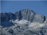
Petka's picture from Pecola to ferrata entrance, if it helps. 
 1
|
|
|
|
| samokham4. 07. 2012 15:24:20 |
Thanks for the picture. It helps quite well.
|
|
|
|
| IgorZlodej4. 07. 2012 18:34:12 |
It will be open when the cable car is running, regards
|
|
|
|
| samokham4. 07. 2012 18:48:57 |
Super, Igor, thanks for all the info!
|
|
|
|
| janez.novak26. 08. 2012 10:24:04 |
I have three questions for Kuclj or Igor. Is there still snow on the way to the Julija path, are crampons and ice axe needed - guidebooks mention hard snow at the end of summer and nasty final chimney. I wonder if the path to Julija is marked? And one more question: in the future I'd like to hike the Gilberti path to the bivouac under Žrđ (what's it called?) then Rosalba Graselli, descend via the Julija path. What's the difficulty of the Rosalba Graselli path compared to our hardest (Hanzovi, Kopiščarjeva, Plemenice, Mrzla gora)?
|
|
|
|
| IgorZlodej26. 08. 2012 18:40:51 |
At the start of this week my colleague and I visited High Kanin, our home mountain. From Nevea by cable car (return ticket 10 €) to Rif Chelso Gilberti. From there to saddle Bila Peč and nice mulatiera towards Biv Marušič, but didn't reach it, turned earlier on red-dotted path to glacier. Crossed snowfields but not necessary, can bypass. At entry geared up and climbed "Julčka". This specially equipped ferrata is pure pleasure, shame so short. At top sat among few visitors, then descended west ridge to Vrh Krnice. Central part lots of new markings of high Rosojan path (definitely too many and too big), luckily run out lower. At Krnice top bit of rest, then down short ferrata Rosalba Graselli, across scree and pathless to marked path and to hut for beer.
Crampons and ice axe not needed. No final chimney at entry, dry, path marked. Don't recommend descent via Julija, difficulty locally C, maybe short D.
| (+1) | | |
|
|
|
|
| janez.novak26. 08. 2012 23:23:03 |
Igor, why don't you recommend descent via Julija - isn't it easier than Rosalba Grasselli (that's locally D by you - to me as hard as e.g. descent from Zadnje okno on Jubilee path)? I think go up harder path, descend easier (Hribi.net says so). Thanks for the answer!
|
|
|
|
| IgorZlodej27. 08. 2012 07:11:02 |
From Kanin recommend descent Slovenian side, i.e. over Vrh Osojnic, then either past DPS or under Prestreljeniško okno to Prevala. Re descents, each must decide for themselves. At least first time don't descend hard path, first get to know it on ascent.
|
|
|
|
| majčica27. 08. 2012 07:55:18 |
uuu super Igor, how beautiful our corners are
|
|
|
|
| alyas28. 08. 2012 20:54:47 |
Hut Gilberti - saddle Bela Peč - mulatiera towards Bivak Marussio - ferrata Julija - V.Kanin - over Dolge prode - Prest.okno - Prestreljenik - saddle Prevala - hut Gilberti
Cable car from Sella Nevea (10 EUR return ticket) starts at 8.30, last descent at 17.30, saves about 700 m ascent and about 1.5 hours.
The whole path is not demanding for experienced alpinists, except ferrata via Julija, which is very well technically equipped, but not long nor very airy/exposed. Since some have asked for comparison with ours, let's say by difficulty and length it is most similar to that from Zgor.Okrešelj to Koroška Rinka and definitely much less than e.g. that over the last Prisankovo okno. As I.Zlodej wrote, first time such paths are not chosen for descent,... but due to its perfect technical setup, ironwork and safe steps, descent is easier than e.g. from Rjavina to Pekel under Stanič hut.
In gorgeous weather today the whole tour with two snack stops took 6 hrs.
| (+1) | | |
|
|
|
|
| JanezKog15. 09. 2012 18:03:55 |
Today to High Kanin from Nevea Saddle via ferrata Julia. Path almost entirely dry, snow, whatever is left, does not pose a problem.
|
|
|
|
| janez.novak9. 10. 2012 08:52:48 |
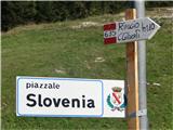
Yesterday from Nevea Saddle via hut Gilberti to Prestreljenik. To Gilberti along the well-marked path 635 right of the ski slope (at the top just below the wall of Bela Peč). Path, which is not on maps, is very suitable for ascent (not as steep as the transport path).
 1
| (+2) | | |
|
|
|
|
| klm9. 10. 2012 14:37:39 |
Here rare errors by Tabacco cartographers appear: on older maps cai635 runs along the ski slope, while in newer editions (no. 019, 027) it is correctly drawn right of the ski slope. However, there is no path cai659, which should branch right a few minutes higher from the junction of path 645/a towards former Planina Goriudi or the shelter there - converted alpine hut. The transport path is pure boredom compared to path 635.
| (+2) | | |
|
|
|
You must log in to post a comment:
If you do not yet have a username, you must first
register.