| smatjaz4. 11. 2013 19:39:28 |
LG, 1. Mainly for playing with data when you get back from the trip. 2. You can draw a track, convert it to a plt file, upload it to hribi.net and earn a beer from someone who will find it useful. 3. If it ever suddenly "thickens" in fog, darkness or otherwise, you can return back along that black line that the device drew behind you when you were still going forward and return to the starting point. 4. In trouble you can read geo latitudes and longitudes quite accurately (when visibility is zero, the walked path is very relative and you have no sense whether it is 1 or 5 km), before your head and body give up, which is very important for narrowing the area for rescuers when they are searching for you. 5. On the GPS map around your position there are marked summits (yes, you approximately know where you are if you know the terrain) and contours, which if you know how to read tell you what lies ahead - hill or cliff, WARNING: all together it is not worth "a broken penny" if you don't know the device inside out!!! ........ while at zero visibility with a map or compass you don't help yourself much. If the weather is nice, you don't need all that stuff at all because from the Julians you can see to Pohorje anyway and besides there are so many visitors in the hills then that you can ask someone for direction almost every few meters - as if there were markers.
Lynx, did I write it right? 
Don't take what is written badly but as a witty description of GPS use, because I got the feeling that I annoyed someone a bit with my descriptions, although it is not my intention to show off up here, but just to advise, given that I know these types of devices (Garmin) quite well, at least those that I own, because technology advances at the speed of light, so I don't follow it the best either.
Anyway, brains in the head, good luck and safe step.
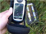
On the first photo, there is a purple drawn track (route plan) that I made for trip planning, or someone else already made it, uploaded to hribi.net, and I just transferred it to the device. The black line is the already walked path.
lp Matjaž
 1 1 2 2
| (+1) |  | |
|
|