|
| lykos8. 11. 2013 23:43:16 |
Hard to comment because it's not clear what topo map they made. I'm almost sure they used some existing map of someone else, in connection with google earth. And even here I doubt that hiking paths were their priority.
It seems that for now the best topo map option for our country is something like Geopedija, or old topo maps, digitized and transferred with Ozi to GPS.
@LG:once they made devices that could remove contour lines from topo maps as needed. Sounds blasphemous, but sometimes it helped in terms of "where are those trails".
Example of your four summits:
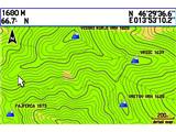 1 1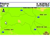 2 2
|
|
|
|
| lynx9. 11. 2013 09:41:34 |
It's the base which is on Geopedija for hiking map. The layer of hiking paths you can also get from PZS.
|
|
|
|
| smatjaz9. 11. 2013 10:27:48 |
Lynx, your last three posts are way too much for my knowledge of maps. Can you (plainly) write if there exists a map for garmin hiking navigation (colorado 300) on which it's visible up to where the road is and from where trail starts? I know the device and its capabilities very well, while maps are my "Achilles heel", although when I have it loaded I quickly learn to read and use it. So topo doesn't give me too many headaches if I manage a bit and help with other maps, but it annoys me that you can't see with one map up to where you can drive with car, and also paths or hiking trails are often deficient or sometimes disappear completely - example route Kokrška Kočna past Ovnove čeri, left at Srednje Dolce past bivouac in Kočna to scree, then on topo "END", no more path and it continues only somewhere in the middle of the wall to Kočna, where the entry to the wall is you can only guess, and it's not properly marked. And I found some such "pearls" on topo and for that reason you can't go to mountains without classic paper map. For every your advice how to improve the thing and make it more
useful I'll be very grateful, as you know "more heads more ideas" 
lp Matjaž
|
|
|
|
| lynx9. 11. 2013 16:12:18 |
For the desired accuracy you'd need TTN5 (basic topographic map 1:5000), but I doubt it's usable in the hills. You can buy them at GURS, most GPS programs can convert them to device format.
I know there are also some pirate variants, but they're probably just scanned hiking 25s and 50s.
|
|
|
|
| smatjaz9. 11. 2013 17:26:49 |
Lynx, thanks
|
|
|
|
| Marky15. 11. 2013 11:50:54 |
I'm still a fan of a handheld GPS device with loaded maps and not a GSM device with maps. Why? Just searching for satellites etc. heavily drains the battery and consequently it empties quite quickly. What does that mean? You have neither GPS nor GSM to call for "help". If you have separate devices then if the GPS battery dies, you still have GSM or if you get lost, damage..., you can still call for help..
Otherwise Topo Adria 2.40 is quite good. Especially with BaseCamp, where you can plan and later review the walked path.. awesome 
| (+4) |  | |
|
|
|
|
| lynx15. 11. 2013 12:57:50 |
by the way, longer-lasting batteries for mobiles are very cheap. They make the thing a bit thicker, that's it.
| (+1) | | |
|
|
|
|
| smatjaz28. 11. 2013 20:24:11 |
Lynx, from practice I give more right to Marky, no offense, but almost no mobile in case of accident and at low winter temperatures lasts much more than 24 hours if you have everything on. In summer I agree! And usually GPSs have 2x AA batteries which you can buy everywhere, even in huts. I usually carry 2 spare sets, so altogether it lasts about 4 days at winter temps, in summer even more. I don't want to be smart, but that's my experience. It's true you carry 0.3 kg (GPS + batteries) more. Actually everyone has to assess how much reserve they want and carry best regards Matjaž
| (+2) | | |
|
|
|
|
| BorisM28. 11. 2013 20:42:09 |
Today the phone (Samsung) froze at 1100 m above sea level, it started working only in the valley. Matjaž is right, for navigation it's best to use a separate device.
| (+2) | | |
|
|
|
|
| ljubitelj gora16. 01. 2014 18:23:35 |
These days it's ideal weather for a bit of playing with various apps for the Nokia mobile phone, since I have the TOPO map already loaded, I have also loaded Sports Tracker, Endomondo, Runkeeper. All these apps have the option to send the walked/run path directly to the internet, if of course someone has a subscription and purchased MB space. Sports Tracker is a bit more interesting, sunrise/sunset, elevation profile, map... Endomondo works better for me, anyway Garmin is just the first among the best, especially Topo map. At the end I reviewed the track in Google Earth or in MapSource. In Google Earth, when looking at ascent and descent height there are deviations, because of the GPS in the mobile and satellites, sometimes it really jumps and consequently the meters are off. I have Nokia X6, not too expensive, so probably the GPS antenna is poorer too. But the thing is quite decent, catches well in mountains, worse under canopy, path can be found with it, if lost it's ok too. All programs are free, no need for any internet via mobile.
 1 1
| (+2) | | |
|
|
|
|
| pohodnik3816. 01. 2014 20:12:08 |
As it suits everyone, these apps work quite decently, it depends on the device, it's also true if you're at a high mountain wall the thing shows wrong data. In the open with enough satellite signal quite accurate - tested in last summer season. I turn the thing on at the start of the tour and don't look until back at the car - end of tour then stop because I use it only for stats and later tour analysis. Where and how is already all in the head.
|
|
|
|
| Flora122. 02. 2014 21:32:45 |
Why sometimes on GoogleEarth an even image doesn't appear, but as if the whole image wasn't loaded?
I have Endomondo on Nokia too, works great.
 1 1
|
|
|
|
| lynx23. 02. 2014 20:54:25 |
|
|
|
|
| bojan7924. 02. 2014 19:10:10 |
Well I think they changed some images recently, because around my village something changed in the last month too.
|
|
|
|
| lynx24. 02. 2014 19:24:53 |
Yes, exactly what I said, since it even writes below on the image. First has part from 2013, second is (whole) 2012.
|
|
|
|
| Flora124. 02. 2014 21:59:23 |
Thanks, bojan and ris. It had to be really recently, because the gap in both my images is 1 month (end February 1., end January 2. image). F***, what did they break now! So nothing can be done, huh?
|
|
|
|
| lynx24. 02. 2014 22:47:50 |
Wait until all the "tiles" are replaced. But if you need it only for images like those above, you can fix the color balance of the ugly half yourself with GIMP, Photoshop or something similar. Or start using pespoti.si, which have the above-mentioned bases.
|
|
|
|
| holcer 15. 05. 2017 17:59:17 |
I bought a used Garmin Dakota 10 for carefree hill walking over rocks and stumps and mushrooming but with it I don't know much how to help myself, what's more last year I almost got lost because I relied too much on it!
Where can I learn more about settings and how to get maps for any area! Please provide a detailed explanation suitable for a pensioner.
Greetings to all hill walkers
Brane
| (+4) | | |
|
|
|
You must log in to post a comment:
If you do not yet have a username, you must first
register.