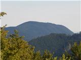
 | Vače - Zasavska Sveta gora
Zasavska Sveta Gora is a popular excursion destination located between Litija and Izlake. From the summit, where the parish church of the Nativit...
2 h |
 | Zaplana (Prezid) - Ulovka
Ulovka is a peak between Zaplana and Zavetišče na Planini nad Vrhniko. From the summit, to which ski lifts run, there is a nice view to the north...
1 h 45 min |
 | Visoko (Mali Kurešček) - Sveti Lenart (Krvava Peč)
The Church of St. Lenart is located on a small hill above the village of Krvava Peč and the Iška River valley. From the summit or a nearby vantag...
2 h 15 min |
 | Predmeja - Navrše (Pot po Robu)
Navrše is a little-known peak southeast of Otliško okno. It offers nice views of the Vipava Valley and the peaks surrounding it....
2 h 15 min |
 | Predmeja - Otliški maj (Pot po Robu)
Otliški maj is a panoramic peak south of Otlica. It offers nice views of the Vipava Valley, Čavna slopes, Golaki (with the vast Trnovski gozd vis...
1 h 45 min |
 | Velike Lašče - Kamen vrh (via Gornje Retje and Grmada)
Kamen Vrh is a panoramic hill located on the northern edge of Mala Gora. From the summit, surrounded by low bushes, there are fine views of parts...
2 h 35 min |
 | Velike Lašče - Grmada on Mala gora (via Gornje Retje)
Grmada (also Grmada above Ortnek) is an 887-meter-high peak located above the village of Vrh pri Poljanah in the Mala Gora range. Just a few mete...
2 h |
 | Mašon (Severjevo znamenje) - Murovica (circular path)
Murovica is a popular excursion point, accessible from the Posavje side, Domžale, or the Moravška Valley. On the summit there is a bench and a lo...
2 h 20 min |
 | Ledinsko Razpotje - Medvedje Brdo (east path)
Medvedje Brdo is a small settlement located north of Hotedršica. The highest point of the village is a pleasant viewpoint on Šinkovcov grič (814 ...
3 h 10 min |
| Ledinsko Razpotje - Medvedje Brdo (west path)
Medvedje Brdo is a small settlement located north of Hotedršica. The highest point of the village is a pleasant viewpoint on Šinkovcov grič (814 ...
3 h 15 min |
 | Zavrh pri Trojanah - Golčaj
Golčaj is a 690 m high hill rising south of Blagovica. At the summit, which has a logbook box and stamp, stands a NOB monument; a few tens of met...
2 h 30 min |
 | Mislinja - Fričev vrh (via Završe)
Fričev vrh is an 881 m high hill located south of Mislinjska Dobrava. From the summit, which has a logbook box with book and stamp inside, there ...
2 h |
 | Šembije - Ahac
Ahac (or Sv. Ahac) is a 799-meter-high peak located east of Ilirska Bistrica. The summit hosts a summit logbox, a cross, and ruins of the former ...
2 h |
 | Planina pri Sevnici - Brest (Bohor) (northern path)
Brest is a peak on Bohor, though it resembles more of a saddle. It is an important trail junction on Bohor, lying between more easterly Oslica an...
2 h 20 min |
| Šentvid pri Planini - Brest (Bohor) (northern path)
Brest is a peak on Bohor, though it resembles more of a saddle. It is an important trail junction on Bohor, lying between more easterly Oslica an...
1 h 50 min |
 | Sveta Katarina (Zgornja Kapla) - Sveti Pankracij (Radelca) (Austrian way)
The Church of St. Pankracij on Radelca is located at an altitude of 900 meters, directly on the border ridge between Slovenia and Austria. The or...
2 h 45 min |
 | Sveta Katarina (Zgornja Kapla) - Sveti Jurij (Remšnik)
The Church of St. Jurij is located on a panoramic hill in the Remšnik settlement, which lies on the slopes of Kozjak. Opposite the church, next t...
2 h 50 min |
 | Dragonoš - Zečak
Zečak is a spacious, panoramic and grassy summit in the eastern part of Žumberak Mountain. The summit logbook with stamp is a few meters away in ...
1 h 45 min |