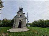
 | Lendava (TIC Lendava) - Lookout tower Vinarium Lendava
The Vinarium Lendava lookout tower is situated in the middle of Lendavske gorice. The 53.5-meter-high lookout tower can be ascended via 240 stair...
30 min |
 | Dolga vas - Lookout tower Vinarium Lendava
The Vinarium Lendava lookout tower is situated in the middle of Lendavske gorice. The 53.5-meter-high lookout tower can be ascended via 240 stair...
30 min |
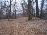
 | Duga Resa - Vinica
Vinica is a forested hill in Kordun, east of Duga Resa and south of Karlovac. The summit is rocky and an HPO point. At the top there is a boundar...
30 min |
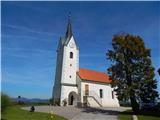 | Krško - Sveti Primož (Kremen)
The Church of St. Primož is located above the village of Kremen, northeast of Krško. From the church or its immediate surroundings, there is a ni...
25 min |
 | Stogovci - Ptujska Gora
Ptujska Gora is a settlement located on a scenic hill south of the Drava Plain. At the top is the parish church of St. Mary, the Ptujska Gora Mot...
35 min |
 | Vonarje - Sveta Ema (Emina tematska pot)
Sveta Ema is a mountain, settlement, and church rising between Sotla and Mestinjščica. Marked trails lead to the summit from Rogaška Slatina, Von...
25 min |
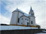 | Sodna vas - Sveta Ema
Sveta Ema is a mountain, settlement, and church rising between Sotla and Mestinjščica. Marked trails lead to the summit from Rogaška Slatina, Von...
30 min |
 | Ladvenjak - Martinščak (težja pot)
Martinščak is a 345-meter hill in the Kordun region, located southeast of Karlovac. At the summit there is the Chapel of Saint Martin, built in 1...
25 min |
| Ladvenjak - Martinščak (lažja pot)
Martinščak is a 345-meter hill in the Kordun region, located southeast of Karlovac. At the summit there is the Chapel of Saint Martin, built in 1...
30 min |
 | Nuskova - Beli breg
Beli breg is a 346-meter-high hill located in Goričko. From its grassy summit, a beautiful view opens up that reaches all the way to the Alps in ...
30 min |
 | Podčetrtek (Terme Olimia) - Castle Podčetrtek
Castle Podčetrtek, or Windischlandsberg in German, is located on a hill above Podčetrtek along a marked trail leading to Silavec or the Tower of ...
30 min |
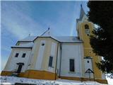
 | Zgornja Ščavnica (Mlin Rožman) - Sveta Ana v Slovenskih goricah
Sveta Ana v Slovenskih goricah is a settlement in the Municipality of Sveta Ana. The parish church of St. Ana stands at the highest point of the ...
30 min |
 | Trdkova - Bogin breg
Bogin breg is a 371-meter-high hill situated between Dolič and Trdkovo. From the summit, where a transmitter stands, there is no nice view due to...
25 min |
 | Gornji Četar / Felsőcsatár - Nagyvilágos mérőtorony (pot zeleni trikotnik)
Nagyvilágos mérőtorony is a former geodetic tower now converted into a lookout tower. It stands atop Četarski breg in western Vas County (Železna...
35 min |
 | Gornji Senik / Felsőszölnök - Janezov breg / János-hegy
Janezov breg / János-hegy is a scenic hill in Slovenian Porabje, rising directly above the largest Porabje village of Gornji Senik. The area lies...
25 min |
 | Trdkova - Tromejnik / Dreiländerecke / Harmashatar (Ježkova pot - through forest)
Tromejnik, known in German as Dreiländerecke or in Hungarian as Hármashatár, is a 390 m high hill located at the tripoint between Slovenia, Austr...
25 min |
 | Oberdrosen - Tromejnik / Dreiländerecke / Harmashatar
Tromejnik, known in German as Dreiländerecke or in Hungarian as Hármashatár, is a 390 m high hill located at the tripoint between Slovenia, Austr...
30 min |
 | Trdkova - Holzmannkogel (on marked path through the forest)
Holzmannkogel is a 393-meter-high hill located north of Tromejnik. The summit is forested and offers no significant views....
35 min |
| Oberdrosen - Holzmannkogel
Holzmannkogel is a 393-meter-high hill located north of Tromejnik. The summit is forested and offers no significant views....
30 min |
 | Spodnje Tinsko - Tinska gora
Tinska gora, at an elevation of 409 meters, lies on the ridge separating the valleys of Zibiški potok and Tinski potok streams. Despite its low a...
30 min |
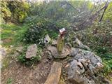
 | Jama Pekel (parking lot) - Pogorišče (gentle path)
Pogorišče is a forested peak located on the Ponikovski Kras. At the top, or slightly below the highest point of the hill, there is a register box...
25 min |
 | border crossing Sotina - Serdiški breg (Rdeči breg)
Serdiški breg (Rdeči breg) is a 416 m high hill located right next to the Austrian border. From its grassy summit, which has a few benches and a ...
35 min |
 | Sotina (Dajčev mlin) - Serdiški breg (Rdeči breg)
Serdiški breg (Rdeči breg) is a 416 m high hill located right next to the Austrian border. From its grassy summit, which has a few benches and a ...
35 min |
 | Sotina - Sotinski breg (Kugla) (by road)
Sotinski breg (Kugla) is the highest peak of Prekmurje at 418 m. From the summit, which features a wooden observation tower with a bell and cross...
35 min |
 | TV Neuhaus am Klausenbach - Sotinski breg (Kugla)
Sotinski breg (Kugla) is the highest peak of Prekmurje at 418 m. From the summit, which features a wooden observation tower with a bell and cross...
35 min |
 | TV Neuhaus am Klausenbach - Stadelberg
Stadelberg is a 418 m high peak located near the highest summit of Prekmurje. A residential house stands at the top, but just a short walk below ...
30 min |
 | Gorica pri Slivnici - Gaj
Gaj is a 419-meter-high hill located above Gorica pri Slivnici. From the logbook box, slightly below the highest point of the hill, there is a be...
30 min |
| Vezovje (bus station Vezovje most) - Gaj
Gaj is a 419-meter-high hill located above Gorica pri Slivnici. From the logbook box, slightly below the highest point of the hill, there is a be...
30 min |
 | Hunting cottage Muljava - Mali Velebit (Petrova gora)
Mali Velebit is a 420-meter-high peak on Petrova gora....
30 min |
 | Maribor - Samotni bor
Samotni bor is a peak northwest of Maribor, slightly further north and higher than the better-known Piramida, Mestni vrh, and Kalvarija. East of ...
30 min |