 | Molnarjev breg - Kamniški vrh
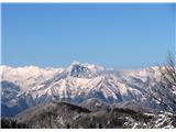
Kamniški vrh is a 1259-metre-high mountain located north of Kamnik, more precisely between Stahovica and the Korošica valley. From the summit, wh...
1 h 30 min |
| Molnarjev breg - Kamniški vrh (via planina Osredek)
Kamniški vrh is a 1259-metre-high mountain located north of Kamnik, more precisely between Stahovica and the Korošica valley. From the summit, wh...
1 h 30 min |
 | Črni Vrh - Pasja ravan
Pasja ravan is the second-highest peak in the Polhograjsko hribovje. A few decades ago, at 1029 meters, it was the highest, but in the second hal...
1 h |
 | Otlica - Sinji vrh
Sinji vrh is a panoramic mountain between Col, Ajdovščina, and Predmeja. It offers views across much of western Slovenia (the sea on clear days)....
1 h 20 min |
 | Vrbiški dol - Koča na Kozleku
The Koča na Kozleku mountain hut is situated southwest of Ilirska Bistrica, just a few meters below the summit of Kozlek. From the summit, there ...
1 h |
 | Podlanišče - Ermanovec
Ermanovec is a 1,026-meter-high peak situated between Cerkno and Gorenja vas, more precisely above Sovodenj and Trebija. Just a few steps from th...
1 h 35 min |
 | Vojsko - Hudournik
Hudournik is a 1,148-meter-high peak on the northern edge of the Vojskarska planota plateau, which lies between the valleys of the Idrijca, Kanom...
1 h 30 min |
 | Podlanišče - Štor
Štor is a 1005 m high peak located directly above the Koča na Ermanovcu hut. The summit itself is forested, but from a meadow just a few dozen me...
1 h 20 min |
 | Podlanišče - Škofje
Škofje is a 973-meter-high peak located above the villages of Čeplez, Planina pri Cerknem, and Podpleče. The summit itself, marked by a small con...
1 h 10 min |
 | Solarji - Deveti konfin (survey point 930) (via Ježa)
Deveti konfin at survey point 930 is located along the marked path leading from Planinski dom pod Ježo towards Očna. From the meadow a few meters...
1 h 20 min |
 | Solarji - Deveti konfin (survey point 942) (via Ježa)
Deveti konfin at survey point 942 is one of two peaks of Deveti konfin in the Kolovrat range, located between Ježa and Očna. From the summit, whe...
1 h 10 min |
 | Cvetrež - Lašček
Lašček, at 1071 m, is the highest peak of the Banjška planota plateau, rising above Čepovanski dol, the Soča valley, and the Idrijca valley. From...
1 h |
| Cvetrež - Lašček (by road)
Lašček, at 1071 m, is the highest peak of the Banjška planota plateau, rising above Čepovanski dol, the Soča valley, and the Idrijca valley. From...
1 h 20 min |
 | Srednji Lokovec - Lašček (via Novo Mesto)
Lašček, at 1071 m, is the highest peak of the Banjška planota plateau, rising above Čepovanski dol, the Soča valley, and the Idrijca valley. From...
1 h 45 min |
 | Bele Vode (Sveti Andrej) - Sveti Križ above Bele Vode (upper path)
The Church of St. Cross is located on Kriška gora, formerly called Oslovska gora. Kriška gora rises above Beli Vodi, or above the streams Ljubija...
1 h |
 | Koča pri Jelenovem studencu - Ledenik
Ledenik, at 1,072 meters, is the highest peak of Stojna, a forested ridge situated between Kočevje and Kočevska Reka. On the summit there is a lo...
1 h 15 min |
 | Gornje Jelenje - Tuhobić (mountain path on Tuhobić)
Tuhobić is a 1109-meter-high peak from which beautiful views open in all directions, with the best sights of Risnjak, Snježnik, Veliki Snežnik, U...
1 h 50 min |
 | Teichalm (Angerwirt) - Gschaidberg
Gschaidberg (also Gschaid-Nock or simply Gschaid) is a 1,239 m high mountain in the Graz Mountains in Austria's Styria.It is part of the Almenlan...
1 h 50 min |
 | Slavica - Velika Slavica
Velika Slavica is a lesser-known peak above the village of Slavica, which lies between Vrata and Delnice. The summit has a logbook box. From the ...
1 h |
 | Omar - Kolevrat
Kolevrat is a lesser-known peak situated above Klenovica. It lies near the path to Kolovratske stijene. From the grassy summit, which has a logbo...
1 h |