 | Dolina Sopote (Zagrad) - Kum
Kum, at 1,220 metres, is the highest peak in the Posavje Hills. As it rises above the Zasavje region, some call it the Zasavje Triglav. At the su...
3 h 10 min |
 | Hudajužna - Porezen
Porezen is a 1,630 m high mountain situated between Davča and Baška Grapa. From the summit, where a large Partisan monument stands, a beautiful v...
3 h 15 min |
 | Cerkno - Porezen (via Labinjske lehe)
Porezen is a 1,630 m high mountain situated between Davča and Baška Grapa. From the summit, where a large Partisan monument stands, a beautiful v...
4 h 10 min |
 | Gornji Grad - Vivodnik (via Semprimožnik and Ovčji stan)
Vivodnik, at 1508 meters, is the highest peak of Menina planina, a plateau rising south of Gornji Grad. From the summit, which has a small observ...
3 h 30 min |
 | Gornji Grad - Vivodnik (past Strmčnik and cave Jespa)
Vivodnik, at 1508 meters, is the highest peak of Menina planina, a plateau rising south of Gornji Grad. From the summit, which has a small observ...
3 h 30 min |
| Gornji Grad - Vivodnik (via Borovnica and Ovčji stan)
Vivodnik, at 1508 meters, is the highest peak of Menina planina, a plateau rising south of Gornji Grad. From the summit, which has a small observ...
3 h 15 min |
| Gornji Grad - Vivodnik (via Borovnica and cave Jespa)
Vivodnik, at 1508 meters, is the highest peak of Menina planina, a plateau rising south of Gornji Grad. From the summit, which has a small observ...
3 h 25 min |
| Gornji Grad - Vivodnik (past Semprimožnik and cave Jespa)
Vivodnik, at 1508 meters, is the highest peak of Menina planina, a plateau rising south of Gornji Grad. From the summit, which has a small observ...
3 h 40 min |
 | Ljubno ob Savinji - Veliki Travnik (Turnovka)
Veliki Travnik, also known as Turnovka by the locals, is located on the western edge of the Smrekovec mountain range. From the summit, which has ...
4 h |
 | Vrtovin - Kucelj (on Čaven) (via Koča na Mali gori)
Kucelj is located on the southern slopes of the Trnovski Forest, northwest of the Vipava Valley. From the bare summit, where a cross stands, ther...
3 h 5 min |
 | Vrtovin - Veliki Modrasovec
Veliki Modrasovec is located on the southern part of the Trnovski Forest near Predmeja. On the summit stands an old military building, which we m...
3 h 15 min |
 | Vuhred - Velika Kopa
Velika Kopa is a 1542-meter-high peak located between Grmovškov dom and the nearby Mala Kopa. From the top, which is only 1 meter lower than the ...
5 h 5 min |
 | Dravograd - Huhnerkogel/Košenjak (via Ojstrica)
Košenjak is located north of Dravograd and the Drava River on the border with neighbouring Austria. Access to Košenjak is possible on foot or by ...
3 h 15 min |
 | Lavamünd - Huhnerkogel/Košenjak
Košenjak is located north of Dravograd and the Drava River on the border with neighbouring Austria. Access to Košenjak is possible on foot or by ...
4 h |
 | Bistriški jarek (border crossing Muta) - Huhnerkogel/Košenjak (via Bivak Piramida)
Košenjak is located north of Dravograd and the Drava River on the border with neighbouring Austria. Access to Košenjak is possible on foot or by ...
4 h 50 min |
| Bistriški jarek (border crossing Muta) - Huhnerkogel/Košenjak (via Sveti Urban)
Košenjak is located north of Dravograd and the Drava River on the border with neighbouring Austria. Access to Košenjak is possible on foot or by ...
4 h 35 min |
| Bistriški jarek (Glasbeni dom) - Huhnerkogel/Košenjak (via Bivak Piramida)
Košenjak is located north of Dravograd and the Drava River on the border with neighbouring Austria. Access to Košenjak is possible on foot or by ...
4 h 45 min |
| Bistriški jarek (Glasbeni dom) - Huhnerkogel/Košenjak (via Sveti Urban)
Košenjak is located north of Dravograd and the Drava River on the border with neighbouring Austria. Access to Košenjak is possible on foot or by ...
4 h 30 min |
| Muta (Zgornja Muta) - Huhnerkogel/Košenjak (past Sveti Urban)
Košenjak is located north of Dravograd and the Drava River on the border with neighbouring Austria. Access to Košenjak is possible on foot or by ...
5 h 30 min |
 | Potoki - Stol (Julian Alps)
Stol (1673 m) is located in the longest ridge of the Julian Alps. The ridge measures 25 km, or 35 km if including the western part. From the summ...
4 h |
 | Trnje / Dornach - Singerberg / Žingarica
Žingarica / Singerberg is a peak on the Austrian side of the Karawanks above the village of Slovenji Plajberk / Windisch Bleiberg. From the summi...
3 h 20 min |
 | Ruše - Žigartov vrh
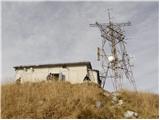
Žigartov vrh, at 1,346 meters, is the highest peak in the eastern part of Pohorje. An "observation" tower once stood on the summit, erected solel...
3 h 15 min |
 | Fram - Žigartov vrh
Žigartov vrh, at 1,346 meters, is the highest peak in the eastern part of Pohorje. An "observation" tower once stood on the summit, erected solel...
4 h 30 min |
| Log - Žigartov vrh
Žigartov vrh, at 1,346 meters, is the highest peak in the eastern part of Pohorje. An "observation" tower once stood on the summit, erected solel...
3 h 35 min |
| Zgornja Bistrica (Center Vintgar) - Žigartov vrh (through Bistriški vintgar and past Ruška koča)
Žigartov vrh, at 1,346 meters, is the highest peak in the eastern part of Pohorje. An "observation" tower once stood on the summit, erected solel...
5 h 15 min |
| Pivola (Reka) - Žigartov vrh (via Petkovo sedlo)
Žigartov vrh, at 1,346 meters, is the highest peak in the eastern part of Pohorje. An "observation" tower once stood on the summit, erected solel...
3 h 55 min |
| Spodnje Radvanje - Žigartov vrh (via Ledinekov kogel)
Žigartov vrh, at 1,346 meters, is the highest peak in the eastern part of Pohorje. An "observation" tower once stood on the summit, erected solel...
4 h 15 min |
| Spodnje Radvanje - Žigartov vrh (southern path)
Žigartov vrh, at 1,346 meters, is the highest peak in the eastern part of Pohorje. An "observation" tower once stood on the summit, erected solel...
4 h 35 min |
 | Slivnica pri Mariboru - Žigartov vrh
Žigartov vrh, at 1,346 meters, is the highest peak in the eastern part of Pohorje. An "observation" tower once stood on the summit, erected solel...
4 h 40 min |
| Zgornja Polskava - Žigartov vrh (through Polskavski vintgar)
Žigartov vrh, at 1,346 meters, is the highest peak in the eastern part of Pohorje. An "observation" tower once stood on the summit, erected solel...
5 h 30 min |
 | Lovrenc na Pohorju - Klopni vrh (via Spodnji trg and on northern path)
From the northwest, Klopni vrh closes off the lower-lying extensive plateau on eastern Pohorje. The horizontal cross-sectional area at 1300 m is ...
3 h 5 min |
| Lovrenc na Pohorju - Klopni vrh (via Spodnji trg and on eastern path)
From the northwest, Klopni vrh closes off the lower-lying extensive plateau on eastern Pohorje. The horizontal cross-sectional area at 1300 m is ...
3 h 5 min |
| Ruše - Klopni vrh (northern path)
From the northwest, Klopni vrh closes off the lower-lying extensive plateau on eastern Pohorje. The horizontal cross-sectional area at 1300 m is ...
3 h 40 min |
| Ruše - Klopni vrh (eastern path)
From the northwest, Klopni vrh closes off the lower-lying extensive plateau on eastern Pohorje. The horizontal cross-sectional area at 1300 m is ...
3 h 55 min |
 | Vitovlje - Veliki Rob (via Vitovlje Lake and over Sekulak)
Veliki Rob is a panoramic peak situated between Kuclj (1237 m) and Čaven (1185 m). From the summit, where there is a cross, there is a nice view ...
3 h 10 min |
 | Lozice - Suhi vrh (Nanos) (gentle path)
Suhi vrh is the highest peak of the mighty karst plateau Nanos at 1313 meters. Although Pleša with its transmitters and Vojko's hut is more popul...
4 h 45 min |
 | Lozice - Suhi vrh (Nanos) (steep path)
Suhi vrh is the highest peak of the mighty karst plateau Nanos at 1313 meters. Although Pleša with its transmitters and Vojko's hut is more popul...
4 h 35 min |
 | Gornji Grad - Špic (via Semprimožnik)
Špic is a 1,499-meter-high peak located right next to the Dom na Menini planini mountain hut. From the summit, near which transmitters are locate...
3 h 15 min |
 | Cerkno - Medrce (via Labinjske lehe)
Medrce is a 1,410-meter-high peak located between Porezen and Hum. From the summit, which features an old bunker, there are nice views of Kojca, ...
3 h 25 min |
 | Muta (Zgornja Muta) - Kozji vrh (at Košenjak)
Kozji vrh is a 1,383-meter-high peak located above Pernice; it is also the highest peak in the Municipality of Muta....
3 h 45 min |
 | Lovrenc na Pohorju - Pesek
Pesek is a 1,423-meter-high peak on Pohorje, located above Koča na Pesku....
4 h 8 min |
 | Zgornja Bistrica (Center Vintgar) - Veliki vrh (on Pohorje) (via Veliko Tinje)
Veliki vrh is a 1344-meter-high peak located above the RTC Jakec - Trije kralji ski slope. The highest point of the peak is in the forest, but ju...
3 h 50 min |
| Zgornja Bistrica (Center Vintgar) - Veliki vrh (on Pohorje) (via Bistriški vintgar)
Veliki vrh is a 1344-meter-high peak located above the RTC Jakec - Trije kralji ski slope. The highest point of the peak is in the forest, but ju...
3 h 45 min |