 | Passo Campolongo - Col di Lana
Col di Lana (Italian: also Col di Sangue, 'bloody mountain') is a 2,452-meter-high mountain located west of the Valparola and Falzarego passes. O...
4 h 20 min |
 | Vršič - Planja
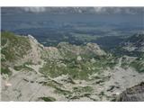
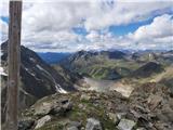
The Planja summit is located between two alpine valleys: Mlinarica on the north side and Zadnjica on the south. From the summit, there is a beaut...
5 h 5 min |
 | Sella di Razzo - Clapsavon (via 210 & 212)
Clapsavon is a 2,462-meter-high mountain in the Carnic Alps in Italy. It lies about an hour's walk west of the 2,474-meter-high Bivera. Both peak...
3 h |
 | Sella di Razzo - Bivera (via Forcella Chiansaveit, Monte Clapsavon, Forcella de Bivera)
Monte Bivera is a 2,474-meter-high mountain in the Carnic Alps in Italy. It lies about an hour's walk east of the neighboring 2,462-meter-high Cl...
4 h |
 | Saddle Sedlo - Bobotov kuk
Bobotov kuk is the highest peak of Durmitor. There are several routes to it. The southern approaches are the shortest, the eastern ones the longe...
3 h |
 | Vršič - Prisank / Prisojnik (Slovenian way)
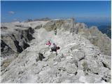
Prisank (also known as Prisojnik) is a 2,547-meter-high mountain situated above the Mlinarica, Krnica, and Suha Pišnica valleys. From the summit,...
3 h 30 min |
 | Passo Pordoi - Belvedere (ridge way)
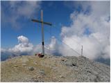
Belvedere is a 2,650-meter-high peak located north of Marmolada, the highest peak in the Dolomites. From the summit, where a small cross stands, ...
3 h |
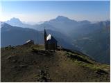
 | Rifugio Ra Stua - Croda del Beco / Seekofel
Croda del Beco (German: Seekofel, Ladin: Sass dla Porta) is a 2,810-meter-high mountain that rises steeply above Lago di Braies (Pragser Wildsee)...
3 h 35 min |
 | Ristorante Pietofana - Cima Formenton
Cima Formenton is a 2,830-meter-high peak in the Tofana group. The mountain lies north of the better-known Tofana di Dentro, with an unmarked tra...
3 h 40 min |
 | Kühtai - Finsteltaler Schartenkopf (western approach from Kühtai and via saddle Finstertal)
(Finsteltaler) Schartenkopf is a peak in the range above Kühtai. From the Finstertal saddlethe easiest access pointit appears quite indistinct, b...
4 h |
 | Passo Gardena - Cima Pisciadu (path 666)
Cima Pisciadu or Pisciadu Spitze is a 2,985-meter-high peak in the Sella mountain group. The mountain is located in the northern part of the grou...
3 h 40 min |
 | La Crusc - Lavarella (western summit)
The western summit of Lavarella is a 3034-meter-high peak in the Lavarella group. Slightly lower than the eastern summit, it also has a marked tr...
4 h |
 | La Crusc - Lavarella
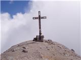
Lavarella (also La Varella) is the second-highest peak in the Lavarella group. From the summit, which has a cross, there are excellent views of t...
4 h |
 | Rifugio Dibona - Tofana di Rozes (via Rifugio Giussani)
Tofana di Rozes is a 3225-meter-high peak located west of Cortina d'Ampezzo. From the top, where a cross stands, there is a nice view of the neig...
4 h |
 | Upper station of cableway on Ankogel - Ankogel
Ankogel, at 3252 m, is among the highest peaks in its mountain group (Ankogel group). Only Hochalmspitze (3360 m) and Großetendk (3317 m) are hig...
3 h |