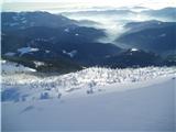
 | Srednja vas - Viševnik (Za Ribnico and via Srenjski preval)
Viševnik is a 2050 m high mountain rising northwest of Rudno polje on Pokljuka. From the summit, where there is a stamp, a beautiful view opens o...
4 h 35 min |
 | Križe - Storžič (through southwest groove)
Storžič is a 2132 m high mountain located in the western part of the Kamnik-Savinja Alps. From the summit, where there is a cross, a beautiful vi...
6 h 10 min |
 | Rogovilec - Velika Raduha (via planina Arta)
Velika Raduha, at 2062 m, is the highest peak of the Raduha range, which rises steeply east of Robanov Kot. From the summit, with its registratio...
4 h 30 min |
 | Planina Polog - Krn (via planina Sleme)
Krn, at 2244 m, is the highest peak of the Krn mountain group, which rises steeply above the central part of the Soča River. From the summit, fea...
6 h 30 min |
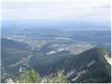
 | Bašelj - Bašeljski vrh (via Sveti Lovrenc)
Bašeljski vrh is a 1744-meter-high mountain located between Mali Grintovec and Storžič. From the summit, where there is a bench and a registratio...
4 h 15 min |
 | Kokra (Podlebelca) - Kalški greben
Kalški greben is a 2224 m high peak and the highest point of the ridge bearing the same name. From the summit, where there is a summit register a...
4 h 45 min |
 | Bašelj - Mali Grintovec (via Sveti Lovrenc and over Bašeljski vrh)
Mali Grintovec is a panoramic mountain located east of Storžič. From the summit, which has a summit register box, stamp, and a pleasant bench, th...
5 h |
 | Bašelj - Mali Grintovec (via Sveti Lovrenc)
Mali Grintovec is a panoramic mountain located east of Storžič. From the summit, which has a summit register box, stamp, and a pleasant bench, th...
4 h 50 min |
 | Zauchen - Hochobir (Ojstrc) (via Božičev graben)
Ojstrc (Hochobir) is the highest peak of the smaller Obir range. It is located west of Železna Kapla (Eisenkappel) on the Austrian side of the Ka...
5 h 5 min |
 | Ferlach - Ferlacher Horn / Grlovec
Grlovec/Ferlacher Horn is a panoramic mountain on which a large cross stands. From the top, there is a beautiful view of the Karawanks, parts of ...
4 h 15 min |
 | Breginj - Stol (Julian Alps) (via Muzec)
Stol (1673 m) is located in the longest ridge of the Julian Alps. The ridge measures 25 km, or 35 km if including the western part. From the summ...
4 h 45 min |
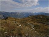
 | Ladina - Sart / Žrd (via Bivacco Marussich)
Žrd, or Monte Sart in Italian, is a panoramic mountain located on the northwestern ridge of the Kanin mountains. The summit, which has a logbook ...
6 h |
| Korito / Coritis - Sart / Žrd
Žrd, or Monte Sart in Italian, is a panoramic mountain located on the northwestern ridge of the Kanin mountains. The summit, which has a logbook ...
5 h 40 min |
 | Breginj - Punta di Montemaggiore
Breški Jalovec, or Punta di Montemaggiore in Italian, is a 1613-meter-high mountain located above the source of the Nadiža River, specifically on...
5 h |
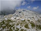 | Žaga - Velika Baba (Kanin)
Velika Baba is the southernmost two-thousander of the Kanin mountains. It is separated from the main ridge to the north by the saddle Med Baban, ...
5 h 50 min |