 | Rimske Toplice - Dom v Gorah (via Ogeški potok)
The Dom v Gorah mountain hut is located east of Hrastnik, just a few meters below the 786 m high peak where the church of St. Jurij stands. From ...
2 h 40 min |
| Rimske Toplice (Šmarjeta) - Dom v Gorah (via Lurd)
The Dom v Gorah mountain hut is located east of Hrastnik, just a few meters below the 786 m high peak where the church of St. Jurij stands. From ...
2 h 40 min |
 | Zidani Most - Veliko Kozje (mimo Gašperjeve koče)
Veliko Kozje is a mountain that rises steeply above the left bank of the Savinja River, descending more gently towards the Sava River. The highes...
2 h 40 min |
 | Gračnica - Veliko Kozje
Veliko Kozje is a mountain that rises steeply above the left bank of the Savinja River, descending more gently towards the Sava River. The highes...
2 h 15 min |
 | Gračnica Valley (Blatnik) - Veliko Kozje
Veliko Kozje is a mountain that rises steeply above the left bank of the Savinja River, descending more gently towards the Sava River. The highes...
3 h 5 min |
| Breg - Veliko Kozje
Veliko Kozje is a mountain that rises steeply above the left bank of the Savinja River, descending more gently towards the Sava River. The highes...
3 h 15 min |
 | Laško - Gozdnik
Gozdnik is a hill that rises steeply above the village of Zabukovica. There is no view from the summit due to the forest, but a bivouac has been ...
3 h 45 min |
 | Laško - Malič
Malič is a 936-meter-high peak situated between Celje and Laško, more precisely above Spodnja Rečica. From the summit, which has a transmitter, b...
2 h 15 min |
 | Štore - Tolsti vrh above Celjska koča (via Žlajfa)
Tolsti vrh (also recorded as Tovsti vrh in some sources) is situated above the Celjska koča ski area. The summit has a logbook box and stamp, but...
2 h 15 min |
 | Radeče - Nebeška gora
Nebeška gora is the highest peak of the Radeče ob Savi municipality. At the summit there is a logbook, stamp, luck bell, and some benchesall plac...
2 h 45 min |
| Zidani Most - Nebeška gora (eastern path)
Nebeška gora is the highest peak of the Radeče ob Savi municipality. At the summit there is a logbook, stamp, luck bell, and some benchesall plac...
2 h 40 min |
| Zidani Most - Nebeška gora (western path)
Nebeška gora is the highest peak of the Radeče ob Savi municipality. At the summit there is a logbook, stamp, luck bell, and some benchesall plac...
2 h 45 min |
 | Laško (cemetery Laško) - Govško brdo
Govško brdo is an 811-meter-high hill located west of the village of Huda Jama above Laško. From the summit, which features a logbook box and sta...
2 h 35 min |
 | Zidani Most - Sveta Marija (Ključevica)
The Church of St. Mary is located on a hill called Ključevica, which rises 1,067 meters above sea level. From the partly vegetated summit, there ...
2 h 30 min |
| Radeče - Sveta Marija (Ključevica)
The Church of St. Mary is located on a hill called Ključevica, which rises 1,067 meters above sea level. From the partly vegetated summit, there ...
3 h 10 min |
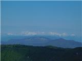
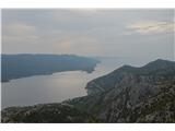 | Bilopolje - Sveti Ilija (Pelješac)
Sveti Ilija, also Zmijino brdo, is a 961-meter-high mountain and the highest peak of the Pelješac Peninsula. From the top, a nice view opens up o...
2 h 20 min |
 | Railway station (Most na Soči) - Veliki vrh (above Lom)
Veliki vrh is located on the northeastern part of the Banjška planota plateau, which rises above Čepovani dol, the Soča river valley, and the Idr...
3 h 15 min |
 | Rimske Toplice - Vrhe (at Gore) (via Ogeški potok)
Vrhe is a forested 781-meter-high peak located northwest of the Planinski dom hut in Gore....
2 h 50 min |
| Rimske Toplice (Šmarjeta) - Vrhe (at Gore) (via Lurd)
Vrhe is a forested 781-meter-high peak located northwest of the Planinski dom hut in Gore....
2 h 50 min |
 | Pásztó - Muzsla (path marked with green plus)
Muzsla (Mužlo) is the highest peak in the western part of the Mátra Mountains, which also include Hungary's highest peak Kékestető. A concrete to...
3 h 15 min |
 | Mošćenice - Kremenjak (past Kalvarija)
Kremenjak is a scenic rocky peak on Učka. The peak is a point on the Istrian Mountain Path. From the peak, which has a summit book box and a bord...
2 h 45 min |
| Mošćenice - Kremenjak (on marked path)
Kremenjak is a scenic rocky peak on Učka. The peak is a point on the Istrian Mountain Path. From the peak, which has a summit book box and a bord...
2 h 40 min |
 | Mošćenice - Planinsko zavetišče Kremenjak (past Kalvarija)
The Kremenjak Mountain Shelter is located on a small peak between Kremenjak and Brgud. The bivouac is of quite unusual shape and has some benches...
2 h 45 min |
| Mošćenice - Planinsko zavetišče Kremenjak (on marked path)
The Kremenjak Mountain Shelter is located on a small peak between Kremenjak and Brgud. The bivouac is of quite unusual shape and has some benches...
2 h 40 min |
 | Mošćenice - Brgud (past Kalvarija and Kremenjak)
Brgud is a scenic peak on Učka. The peak is a point of the Istrian Mountain Path. At the highest point of the peak, there is only a pile of stone...
3 h 15 min |
| Mošćenice - Brgud (along the marked trail and past Kremenjak)
Brgud is a scenic peak on Učka. The peak is a point of the Istrian Mountain Path. At the highest point of the peak, there is only a pile of stone...
3 h 10 min |
 | Mošćenice - Balin (past Kalvarija and via Brgud)
Balin is a less known peak on Učka between Brgud and Maj. From the peak, there is a beautiful view of the Kvarner, part of Istria, and the Učka r...
3 h 45 min |
| Mošćenice - Balin (on marked path and via Brgud)
Balin is a less known peak on Učka between Brgud and Maj. From the peak, there is a beautiful view of the Kvarner, part of Istria, and the Učka r...
3 h 40 min |